Friday, August 2, 2024

10th anniversary post: What is a complete street?

bus shelter on wide busy street
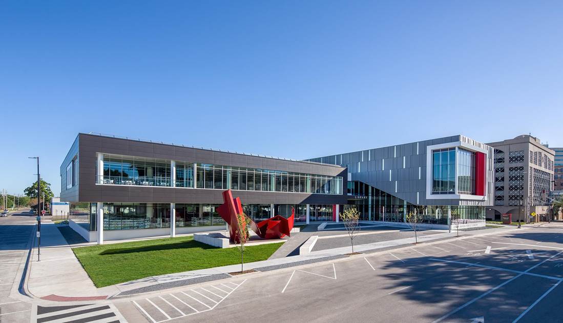
Edgewood Road SW near the new library is not a complete street, 
but a 10-foot side "trail" and daytime bus service help

Ten years ago, I explored the concept of complete streets, with profiles of three eastside streets "currently suited only to those physically fit and bold of spirit" that I thought could use a bit of complete streets treatment. In the years since, Cedar Rapids has added numerous sidewalks around town, as well as bike lanes and trails, converted most one-way streets back to two-way, and made important zoning reforms. On the other hand, we're turning Mt. Vernon Road into a highway, reserving important land adjacent to downtown for unproductive uses, and everywhere doubling down on car-dependence.

Later in 2014, the city adopted both a Complete Streets Policy and a comprehensive plan, Envision CR, which included complete streets. Envision CR, revised in 2023, defines complete streets as "streets that serve a variety of functions and potentials" (p. 127), with features like separated bike lanes, sidewalks, crosswalks, street furniture, and better drainage, all supported by "special" lighting graphics and landscaping. It identified as ongoing tasks "sign and mark streets for bicyclists" and "retrofit high priority corridors with sidewalks and pedestrian amenities" consistent with the city's Complete Streets Policy (p. 128).

The three incomplete streets I pulled off the top of my head in 2014 have since seen varying impacts of complete streets ideas.

(1) A Avenue NE (small impact).

A Avenue approaching 8th Street
Turn right to enter I-380: 800 block of A Avenue NE
(Google Earth screenshot, 2021)

Back in the day this was a residential/commercial street. According to the 1953 Polk's Directory, more than 300 people then lived along A Avenue between Coe College and 1st Street downtown. There were also numerous commercial establishments, including a grocery store at 717, a barber shop (708), a bar (800), a restaurant (713), a vet (801), and two cleaners (719 & 835). Imagine the activity on that street at any time of the day seventy years ago, and ponder what has been lost to the interstate highway and medical district expansion.

Today A Avenue's principal purpose now is to provide auto access to St. Luke's Hospital, I-380 entrance at 8th Street, and Quaker Oats. Its four lanes carry 5000 cars a day below 7th Street. In 2021 there was no count above 7th Street, but in 2017 the count was 7600 at the entrance to the interstate, then back down to 5800 in front of St. Luke's Hospital.
aerial view of A Avenue at 7th/8th Streets
Aerial view of the same area
(Google Earth screenshot, 2021)

I'd chosen A to examine, because it's the one of the few available connections between the Mound View neighborhood (including Coe College) and downtown; really the only alternative is high-traffic 1st Avenue. In 2014 I was torn between narrowing A and shifting through car traffic onto 1st, or doing the opposite. Nothing as radical as either of those has been attempted, but there have been two small improvements: the intersection at 10th has been changed from traffic signals to a three-way stop, and brick crosswalks have been added across 12th a.k.a. Coe Road. 

striped crosswalks leading to brick hospital building
newish crosswalks, A Ave and Coe Road NE
(St. Luke's Hospital in background)

Back then, I said biking was "do-able, but scary, particularly near the interstate," and that walking was complicated at every intersection. That is still true.

I'm probably more in favor now than I was then of closing the interstate altogether. A Avenue shows the damage to urban form brought by an intracity highway and an auto-oriented medical district, and how difficult it is to repair that once done.

(2) 10th Street E (moderate impact).

street with bike lane and man riding on sidewalk
300 block of 10th Street, heading towards Mercy Hospital
(Google Earth screenshot from 2021)
(Note the gentleman on the sidewalk, unimpressed by the bike lane)

This should be called the Medical Mile, as its nine blocks are bookended by St. Luke's and Mercy Hospitals. Numerous medical offices are located along the way, as well as a lovely historic Firestone Tire establishment...

historic Firestone at 2nd Av and 10th St
Firestone Complete Auto Care, 205 10th St SE

..., two churches, and McKinley Middle School (slated for closure, I'm not sure how soon).

Ten years ago, 10th Street was four lanes wide; in 2020 it got a road diet, and is now three lanes with bike lanes on each side. Average daily traffic counts (2021) peak at 10,700 at 3rd Avenue, about 10 percent higher than in 2017.
street with bike lane and tree hanging into it
400 block of 10th Street SE: bike lanes are nice,
but the trees could use a bit of trimming

I'd chosen 10th Street because along most of its length it forms the border between the MedQuarter and the Wellington Heights neighborhood. So, how easily it is crossed is at least as important as how easily it can be traveled by non-car modes. Narrowing the car portion of the street helps, as do the crossing treatments at 3rd Avenue, but the traffic lights at 4th and 5th Avenues still seem to take forever. 
parking lot behind a traffic signal
Needs some place to walk to: 4th Avenue and 10th Street, 2019

It may be that what can be done to complete 10th Street has been done, and we now need to look at what's around it. Physicians Clinic of Iowa (202 10th) and Mercy Hospital (701 10th) are massive campuses that are hard to get around/through, and the same may well come to be true of whatever replaces McKinley Middle School (620 10th). The intersection at 8th Avenue, which borders the Oak Hill Jackson neighborhood, is being converted into a roundabout, with the jury out on the pedestrian-friendliness of its design. 
Constructing roundabout at 10th St and 8th Av
(McKinley Middle School in background)

Depending on how the roundabout turns out (ha ha!), a traditional intersection with four-way stops (and no slip lanes) might have been preferable for non-car travelers.

(3) 32nd Street NE (no impact).

map showing walk/bike route from Overlook 380 apts to Hy-Vee
There's a sidewalk, but crossing I-380 is rough:
grocery shopping from the Overlook 380 apts
(Google Earth screenshot)

32nd Street is a two-lane, roughly two-mile-long east-west street that runs through the Kenwood neighborhood. It connects 1st Avenue, which is running northeast-southwest at this point, to Center Point Road, which runs north-south. We're getting into suburban traffic patterns at this remove from the core: 29th Street does the same thing in pretty much the same way, but the next closest east-west connection is not until Collins Road. I'd included it on my 2014 list because it's such an artery, passing along the way several apartment buildings, Collins Aerospace, a large Hy-Vee grocery store, the Cedar River Trail, and an entrance to I-380, before it becomes Glass Road and continues on westward. Average daily traffic counts (2021) on 32nd range from 8100 near 1st Avenue to 9300 near the highway; in 2017 the peak was 13,900 near the highway.

In 2014 I complained of high traffic speeds, difficult cycling, and (relayed from Niles Ross) incomplete sidewalks that where they did exist were in poor condition. I imagined, in order to complete the street, "more and smoother sidewalks; calming car traffic with four-way stops at C Av, Eastern Av, and Prairie Dr; sharrow signs, since I don't think the street is wide enough for bike lanes; relaxed zoning in order to allow small commercial development along the street; and a bus line that runs back and forth along 32nd/Glass from 1st to Edgewood." That list has five things on it! which said a lot about the street's needs.

Ten years later, not much has changed on 32nd Street. The sidewalks on the 1st Avenue end are still chopped up, though there are multiple markings suggesting repairs are imminent. 

sidewalk with maintenance markings
32nd Street sidewalk, with purposeful markings

Those sidewalks still terminate at F Avenue (north side of the street) and G Avenue (south side of the street. The car traffic still doesn't stop, there are still no bike markings (not even the dreaded sharrow), and bus service is still at the ends of the street rather than along it. I don't remember what commercial development I thought possible back then, but a widely-praised little restaurant, Loosies, has popped up between Oakland and Center Point Roads.

Loosies Restaurant, 1611 32nd St NE
Loosies, 1611 32nd St NE

🌞

As the city presented Envision CR to the public ten years ago, veteran reporter Dale Keuter said he'd seen plenty of plans end up in the "dust heap" (Smith 2014). It's too early to say that's where the complete streets policy is headed. Progress is of necessity going to be gradual, and would-be destinations like the casino, the MedQuarter, and the greenway are always going to get more attention. But as an exceptionally car-dependent city in the 21st century, which has both seen its share of weather disasters and wants to attract young talent, we can't afford to put the day-to-day lives of residents on the back burner.


SEE ALSO: Jane E. Brody, “Keeping Older Pedestrians Safe,” New York Times, 5 January 2015
Spencer Gardner, "Strength Test #6: Can Children Safely Walk or Bike in Your Town?" Strong Towns, 5 April 2017
Sean Hayford Oleary, "If We Want a Shift to Walking, We Need to Prioritize Dignity," Strong Towns, 28 July 2023

ORIGINAL POST: "What is a Complete Street?" 13 August 2014

Wednesday, July 24, 2024

Nice Drivers of America, Please Stop Doing This One Thing!

Marion Parks Trail crossing Lindale Drive, 2012
It's nicer now:
Grant Wood Trail crossing at Lindale Drive, 2012

(7/24/2024) As I walk and ride on our city's streets, I seem to be encountering more aggression this summer than usual. In these fraught times, there is ample fodder for speculation on whether and why. However, I am not here to talk about that, because my market research team informs me that overly aggressive people do not read this blog.

So, instead, I'm going to complain about... courtesy? With all the hate I'm getting, I'm complaining about... love? You would think we need all the time, love and tenderness we can get, and I guess that's valid, but I keep feeling someone's misplaced courtesy is going to get me killed.

Sunday afternoon I was riding on the Grant Wood Trail when I came to the intersection with Lindale Drive. There is a push button for crossing, but there were only two cars on Lindale, so I figured I would hang back and let them pass. Alas, driver #1 spotted me and stopped to wave me across. How courteous! How neighborly! How... dangerous! Driver #2, no doubt unaware of this selfless act,  swerved and accelerated right across the path where driver #1 had encouraging me to cross. What degree of brokenness would my body now be in had I accepted the original offer?

Unaffected by this drama, driver #1 continued to sweetly but obliviously wave me across, as more vehicles arrived from both directions. But I have seen this maneuver any number of times and I will not cross in those situations. Honest to Pete, fella, did you not see what your courtesy almost led me into? 

stop sign on 3rd Avenue SE
3rd Avenue SE: Do stop here

If you as a driver encounter a stop sign or a red stop light, you should stop at it. That's the law. If you come to a crosswalk with flashing lights, you should also stop at it. That's also the law, I think. If there's someone in the process of crossing the street, you should stop. It's against the law to hit them, although I found it's not against the law to almost hit them.

My concern here is not with any of those situations. I'm talking about when you as a driver are not obligated to stop, but choose to do so out of an excess of courtesy. Your kindness is well-intentioned but misplaced.

The world we live in is full of anger, and between talk radio and car commercials, anyone is a target. In June 2022, in downtown Cedar Rapids, an enraged pickup driver at a green light pulled around two (properly) stopped cars and into a group of people crossing the street (Lenz 2022). Two women were seriously injured. The driver was arrested but acquitted at trial. The circumstances were unusually political, but the anger and aggression are not. Not everyone is as nice as you, Mr. or Ms. Courteous Driver. I am over here, 30 feet from the street, trying to avoid it all. Please leave me alone!

apartments on narrow street
20th Avenue SW: Soon people will be crossing this street to get to the
Westside Library. Keep driving.

New question: What if there's no one else around, no impatient driver #2 to zoom around you and potentially injure someone, just you in your SUV and someone on foot or bicycle waiting to cross the street? Here there's no danger of serious injury, so a lot of what we've said above doesn't apply. However, I would still keep going, if I were you. If I'm the pedestrian, I'm waiting for you to drive by so it's free for me to cross, a process that takes at most five seconds. However, if you slow to a stop, and motion me across, and I perceive all that, we've taken multiple times that amunt of time. By the time I start to cross, I would have been across, if only you'd kept going. It's not dangerous, just inefficient. Your kindness, while still admirable, is producing frustration.

In fraught times, we need to be patient and forbearing with each other, and in densely-populated cities we need to give everyone some space. Sometimes a little generosity can go a long way. But if not thought through, trying to do someone a favor can end in disaster. In those situations, it's better for everyone if you'd just please maintain course and speed, and we'll all get where we're going in one piece!

Friday, July 19, 2024

US Census Data on Non-Car Commuting


#3 bus runs along 3rd Avenue SE, 2020
0.7 percent of Cedar Rapids residents reported 
commuting to work by bus

The U.S. Census Bureau's American Community Survey annually asks respondents how they get to work. Nationwide in 2022, 68.7 percent of people drove to work alone, while 9.6 percent carpooled, for a total of 78.3 percent in private cars. Among the rest, 3.1 percent took public transit, 2.4 percent walked to work, 0.5 percent biked to work, and 1.5 percent got there by some other means, such as taxi or motorcycle. 15.2 percent of respondents worked from home, nearly three percentage points down from 2021.

I have to say I was surprised how many people walked, particularly relative to cycling. State data yields some surprises. While New York (21.5 percent), New Jersey (8.0), and Massachusetts (6.2) unsurprisingly lead on public transit, Hawaii comes in at #6 (3.5 percent). The state with the highest proportion of people walking to work is... Alaska, with 7.3 percent, followed by New York (5.6), Hawaii again (4.5), and... Montana (4.4). Oregon has the highest proportion of commuter cyclists (1.3 percent), followed by Colorado and Montana again (both at 1.0 percent). Right behind them are Hawaii and... Wyoming (both at 0.9 percent).

PUBLIC TRANSIT

WALKING
CYCLING
1. New York21.51. Alaska7.31. Oregon1.3
2. New Jersey82. New York5.62. Colorado1
3. Massachusetts6.23. Hawaii4.52. Montana1
4. Illinois5.64. Montana4.44. Hawaii0.9
5. Maryland45. Vermont4.24. Wyoming0.9
* * *
* * *
* * *
45. Alabama0.346. Florida1.445. Alabama0.1
45. Arkansas0.346. Nevada1.445. Arkansas0.1
45. Mississippi0.348. Georgia1.345. Kentucky0.1
45. New Hampshire0.349. Alabama1.245. Mississippi0.1
45. North Dakota0.349. Tennessee1.245. Tennessee0.1
45. Oklahoma0.3

45. West Virginia0.1

These are obviously small magnitudes, which can be easily over-interpreted, even without considering that random sampling error is going to invalidate any attempt at precise ranking. But what if we added those three percentages to get an overall sense of how many people were taking urbanist alternatives to private cars? 

Alternative commuting is found most in the West and Northeast, least in the South
 

The Census data on commuting are also available for towns, although only a few large cities in each state. Six Iowa places were included in the 2022 survey. While Iowa is in the middle of the pack of American states, these six cities demonstrate the wide variety of places and experiences in any state. [Where incidence among men is significantly higher than for women, I indicate with "m," with "f" where more female respondents chose that mode.]

MODEIOWASIOUX CITYAMESCEDAR RAPIDSDAVENPORTDES MOINESIOWA CITY
Drove alone76.182.766.376.370.671.254.3
Carpooled810.56.86.211.39.78.8
Transit0.80.75.60.71.51.25.1f
Walked2.91.19.5m2.22316.3f
Bicycle0.402.9m0.10.20.83.7m
Cab, motorcycle, &c.0.90.30.80.61.70.60
WFH114.78.113.812.813.411.8

Ames and Iowa City, home to the two flagship state universities, have percentages for all urbanist alternative modes of 18.0 and 25.1, respectively, both far higher than the statewide figure of 4.1 percent. Des Moines (5.0) and Davenport (3.7) are around the statewide number, with Cedar Rapids (3.0) and particularly Sioux City (1.8) coming in under that. In Sioux City, 93.2 percent of respondents reported commuting to work by private car, compared to 79.3 percent nationwide.

People choose how to get to work for personal reasons, but their choice is shaped by city design, weather, and culture. Given that the lowest number of non-drivers is found in the southeast with its relatively clement winters but newly-sprawled metros, maybe weather is the least important of the three. Culture is a hard phenomenon to specify, but it's worth noting that Joe Biden won the vast number of 2020 electoral votes in the top one-third of states in urbanist alternative percentage, while Donald Trump won the vast number of electoral votes in the bottom one-third. Which came first, the culture or the transportation choices? Which shaped which?

Beyond this, I can only say that my city of Cedar Rapids can be doing a lot better at facilitating alternative means of commuting. Completing our trails network will help. Is there more we should do?

Tuesday, July 16, 2024

Film review: "Cooked: Survival by Zip Code"


Cooked poster

Cooked: Survival by Zip Code. Directed by Judith Helfand, 2020.

The documentary Cooked: Survival by Zip Code had its genesis in telling the story of a tortuous heat wave in Chicago in July 1995, in which 739 people died. Filmmaker/narrator Judith Helfand observes early that this event is "not part of our collective memory" the way that 9/11 or Hurricane Katrina are. Author Eric Klinenberg, who served as content advisor for Cooked, called the heat wave a "disaster in slow motion," which might have made it less memorable.

Judith Helfand
Judith Helfand (from pbs.,org)

For urbanists, the Chicago heat wave is recalled mainly thanks to Klinenberg's book, Heat Wave: A Social Autopsy of Disaster in Chicago (University of Chicago, 2003), which investigated the effects of place ("zip code") on mortality in the event. Klinenberg's book is plugged by Jane Jacobs in Dark Age Ahead (Random House, 2004), which I had just finished rereading before I saw the film. Jacobs praises Klinenberg for pursuing the trail of evidence to make significant connections, rather than fitting the catastrophe into a convenient existing narrative. 

As Helfand spins out the story, we see the City of Chicago's improvised response, including a bunch of refrigerator trucks full of corpses that were parked outside the coroner's office for weeks until they were able to sort through all the bodies. We see Mayor Richard M. Daley at press conferences doing rather obvious blame avoidance. It took years for Klinenberg's research to clarify what a lot of people already suspected: the deaths during the heat wave were predominantly occurring in neighborhoods that were largely nonwhite and poor. It is in those neighborhoods--Englewood and North Lawndale are two examples--where large numbers of people don't have air conditioning, have their windows nailed shut to thwart home invasion, lack nearby grocery stores where they could buy ice, and lack places to gather (like public libraries or senior centers) where they might find relief during hottest part of the day. (Some police stations made themselves available, but not surprisingly there were few takers.)
Grocery store and McDonald's on busy street
Getting better in Gage Park? Pete's Fresh Market, 57th and Kedzie
(Google Earth screenshot)

Cooked draws the obvious conclusion: Those who died in that heat wave almost 30 years ago, like those who died or lost their homes in Hurricanes Katrina and Sandy, died of heat or some other proximate cause, but what killed them was the systemic racism and poverty. "This disaster was man made," Helfand concludes. (For the disproportionate impact of urban heat islands on poor people, see Fitzpatrick 2024 and Anderson and McMinn 2019.) Here Jacobs, following Klinenberg, makes the additional point that black neighborhoods with better urban fabric had a lot fewer deaths than North Lawndale.) 

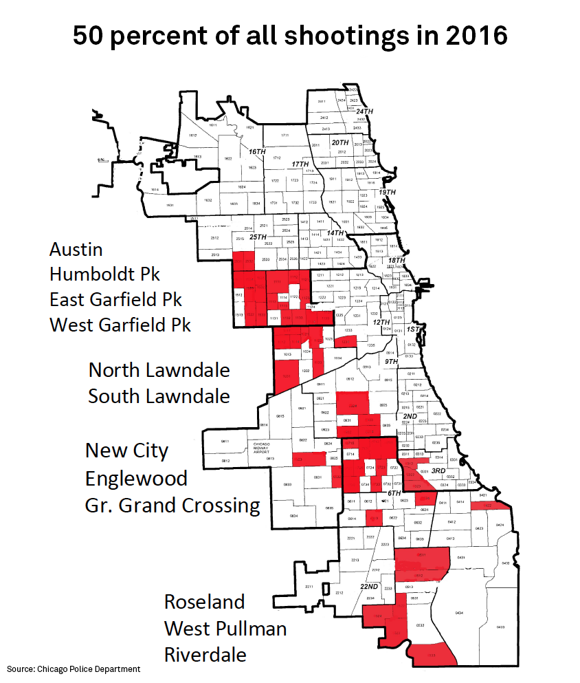
There is some though not very much attempt to describe how racism in particular is responsible for so much death and misery: there is a brief discussion of redlining, and how that influenced blacks' ability to buy and maintain their homes; there are some pictures and memories of a vibrant business district in Englewood that no longer exists since manufacturing employment dried up; and research showing segregation (both racial and economic) has devastating lifelong effects on people consigned to the underclass. 

Chicago shootings by neighborhood 2016
Concentrated poverty affects crime victimization, too
(Source: Pattillo et al. 2018)

Helfand spends too much time staging "gotcha" questions for people who provide disaster preparedness equipment and services. (The city now has its own refrigerator truck for corpses, so it no longer will have to use trucks owned by private firms!) Given the accumulated evidence, it's fair to ask why we spend so much on equipment and flood walls to reduce damage from extreme weather, but don't address the poverty and racism that are at the root of disaster mortality ("extreme social fault lines"). I just don't think it's fair to ask people who are immersed in other things. 

16th and Central Park in North Lawndale, 2022
(Google Earth screenshot)

Late in the film we meet Michelle Dauber, author of The Sympathetic State: Disaster Relief and the Origins of the American Welfare State (University of Chicago, 2012), who argues that those impacted by natural disasters are seen as deserving of help, but "our history and tradition" is that the poor do not. She speculates that people with resources can imagine being impacted by a weather event, and want and expect to be protected, but they can't imagine being black or extremely poor. I would add that we know how to build flood walls and levees, and how to mitigate the effects of urban heat islands (Kingson 2024), but even expensive engineering is less complicated than solving racism. So the film shows us the irony of a lavishly-funded tornado response drill amidst the abandoned and derelict buildings of Englewood. (I make the same argument about Bike to Work Week.)

As a social scientist, I would have liked more discussion of the ways in which racism and poverty have informed and been replicated by policy choices, and how those choices have differentially affected people's life prospects. I don't remember them even mentioning the Interstate Highway System, or antiblack riots, of which Tulsa's is the best known but Chicago had one, too, two years earlier, in 1919.

Houses and shops that got bulldozed for the Dan Ryan Expressway
(my photo at the National Museum of American History, Washington, D.C.)

The coverage in Cooked of how the heat wave played out in poor black neighborhoods is eye-opening and shocking to the conscience. There's not a lot about what needs to be done about racism and poverty, only that it needs to be done. So it's too easy for a viewer to say, well, I'm not racist, so what can I do? Many people know about slavery (which ended in 1865), and Southern Jim Crow laws, but it's less widely known how racial preference has pervaded American society since then, and even racial preferences that have ended (like in housing) have persistent effects. One of the things that keeps your humble blogger humble is that as a white person born to a middle class family in suburbs that were long closed to nonwhites, he has had opportunities that others have not had.

Undoing those advantages is not going to be easy. I think part of it is going to be to create a broader social safety net, so that social goods are not zerosum i.e. the perception that any remedial gains made by blacks are going to come at the expense of whites. Neoconservative economic policy and loose inheritance taxes have been good for a few but have created vulnerability for the many--of all races--that has constrained social justice (and made a lot of young people cynical about capitalism in general) while limiting opportunities for anyone not a "knowledge worker." Most people who oppose housing integration are worried about their property values, which comprise the larger part of their life savings.

row of rooming houses
Poverty is complex: housing matters, but so do transportation
 and connections to opportunities

If we can tamp down the widespread and mostly accurate feeling that if you fall no one is going to be there to catch you, then we can move on to undoing the effects the policies that have favored white people for years, which means... reparations. We need some intelligent, inclusive way of compensating for years of thwarted opportunities.

Short of that, and I admit these goals seem overly ambitious these days, we need to make policy with more attention to second-order consequences, specifically how it will affect poor and other vulnerable populations. The good news is the double-win of addressing poverty and racism means, not only we do right by the ideals we profess like equal justice and opportunity, but also, everyone is better off. Pete Saunders, whom I quote at every opportunity, argues on his Substack (as well as in Crain's Chicago Business) that "inequality is inefficiency," and "the industrial cities of the north have long been hamstrung economically by the most intense racial divides in the country," in part because "white Northern community leaders aggressively worked to keep the races apart."

If we can make inclusive opportunity the focus of broad public policy, we make a lot of social goals achievable. Helfand's documentary vividly shows the awful human consequences of not doing that.

SEE ALSO: 

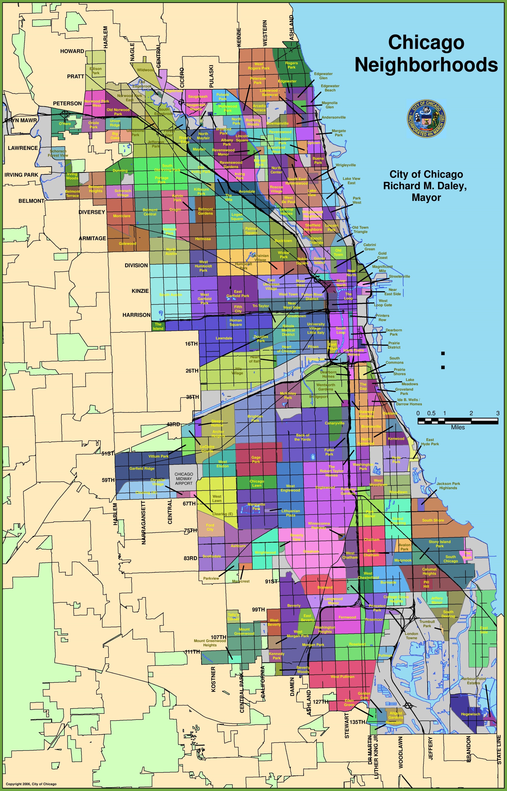
"Map of Chicago Neighborhoods," map-of-chicago-neighborhoods.jpg (2086×3255) (ontheworldmap.com)

For the role of large retailers in concentrated poverty, see Susan Holmberg, Power Play: How Monopolies Leverage Systemic Racism to Dominate Markets, and What We Can Do to Democratize Economic Power (Institute for Local Self-Reliance, 2024). Maybe we should start by vigorously pursuing anti-trust enforcement, instead of dismantling the regulatory apparatus. In the meantime, communities are often at the mercy of megaretailers, megabanks, and megawaste disposal firms. A video presentation by Holmberg is available here.

For efforts at inclusive investing, see Lynne Richardson and Tracy Hadden Loh, "Helping Community Leaders Buy Back the Block," Brookings, 11 July 2024. "Redefine what kinds of projects are considered good when evaluating impact and return on investment. If a small project brings new and/or additional needed goods, services, and amenities to a community and performs financially to be sufficiently profitable and self-sustaining, that is good. If such a project is led or owned by a local resident or a person of color (inclusive economic development) and is not extractive (as opposed to businesses offering check cashing or furniture rental at predatory rates) and is not detrimental to residents’ life expectancy, that is even better. If such a project checks all of these boxes and is also desired by residents, that is the Holy Grail."

Friday, July 12, 2024

10th anniversary post: Dark Age Ahead (And Maybe Closer?)


Jane Jacobs (1916-2006)

Jane Jacobs, Dark Age Ahead. New York: Random House, 2004, 241 pp.

Jane Jacobs wrote this "gloomy but a hopeful book" (p. 3) late in her life, and I read it ten years later. Now, ten more years later, I am reading it again. Not much seems to have changed: American society still seems poised at the fork in the road described by the passage I quoted back then:

Is suburban sprawl, with its murders of communities and wastes of land, time, and energy, a sign of decay? Or is rising interest in means of overcoming sprawl a sign of vigor and adaptability in North American culture? Arguably, either could turn out to be true. (169-170)

I was probably more inclined to the hopeful option in 2014 than I am today. As a student of American politics, I've seen so many unforced errors and so much willful delusion in the last ten years that it's hard to be very hopeful. 

🌞

Dark Age takes its title from the name commonly given to the period of European history following the fall of the Roman Empire, but she points out the numerous cultures in human history have collapsed and "become literally lost" (4). Yes, the Middle Ages had Charlemagne and Thomas Aquinas, but 11th century French peasants were literally eating dirt and dying young.

So much had been forgotten in the forgetful centuries: the Romans' use of legumes in crop rotation to restore the soil; how to mine and smelt iron and make and transport picks for miners, and hammers and anvils for smiths... In districts where even slaves had been well clothed, most people wore filthy rags.... Citizenship gave way to serfdom; old Roman cities and towns were largely deserted and their underpopulated remnants sank into poverty and squalor; their former amenities, such as public baths and theatrical performances, became not even a memory. (7-8)

As challenges arise, feedback is ignored, and knowledge stabilizing forces is also ignored if not actively suppressed. "I have written this cautionary book in hopeful expectation that time remains for corrective actions," she concludes in the introductory chapter, and proceeds with a series of warnings about five "pillars of our culture" (24). Core problems, like racism, environmental destruction, crime, political alienation, and surging inequality, arguably flow from the decline of these pillars.

Chapter 2 on families notes "Not TV or illegal drugs but the automobile has been the chief destroyer of American communities" (37). Families are stressed by car-dependency--which is as strong as ever in most of the country--as well as the price of housing. Twenty years ago, when the book was published, the median housing price-to-household income ratio in the U.S. exceeded 6.0 for the first time since the 1950s. It peaked at 6.81 two years later, and then resumed climbing in 2012. It is now 7.70 (longtermtrends.net; data are from the Federal Reserve Bank of St. Louis and the U.S. Census Bureau), which is scary.

Chapter 3 on higher education argues that it has become a matter of "credentialing, not educating... This is not in the interest of employers in the long run," but it provides hiring agents with a quick-and-dirty indicator of success (44-45). Remarkably, in my own career I have encountered dozens of students who come with their own thirst for knowledge, but alas, there are not enough of them to keep the college's doors open. If anything, the demographic cliff faced by colleges, along with the suspicion of independent knowledge fostered by powerful interests discussed in Chapter 4, have exacerbated the credentialing obsession. So good teachers are "despairing" (62), but more crucially, our culture loses the "critical capacities and depth of understanding" needed to make stabilizing corrections (63).

Chapter 4 on science talks about the widespread failure to study problems by observing, gathering and drawing conclusions from evidence, as opposed to fitting everything into accepted dogma. Happily for urbanists many of the examples have to do with automobile traffic. And of course, we're still arguing about climate change, with disasters crashing all around us.

Chapter 5 on taxation discusses how federalism in Canada as well as the U.S. has left cities without the autonomy to solve their own problems. In 2004 Toronto was getting slapped down by Ontario in the name of laissez-faire economics; these days the State of Iowa uses preemption against cities as blood sport for any reason at all. (We can't even prevent the sale of fireworks within the city limits.) And not just Iowa, of course, given the State of New York's last-minute veto against New York City's congestion pricing plan is still fresh in our minds. Most people, and most of the economy, lives in cities, but their residents can't negotiate the terms by which they will live together.

Chapter 6 on the failures of professional self-policing brings to mind the waste in federal anti-recession grants in 2008-10 and 2020-21. I remember commentary to the effect that President Obama was so naive to expect that corporate recipients of bailout money would use the largesse for the good of the economy rather than for the good of themselves, since of course businesses were supposed to focus on their own bottom lines rather than any public purpose. Today, nobody trusts anyone to handle artificial intelligence technology well. Of course, in politics, we've seen the repeated failures of the Republican Party to discipline or even restrain the egregious Donald Trump. (For the failures of both parties in this presidential election, see Levin 2024.)

🌞

Jacobs concludes with some advice on how to recognize and reverse Dark Age "spirals." Unwinding, the title of chapter 7, requires clear thinking, informed self-confidence, adequate capital, and "redundancy of mentors and examples" for broad diffusion of essential skills (159). Again, urbanists will be pleased to see her use housing as an example, as she traces the roots of our current difficulty from years of underinvestment during the Depression and war through exclusionary zoning to the waste of suburban sprawl (also exclusionary). She did not live to see the 2007 housing market collapse but clearly saw it coming. She also did not live to see Peter Calthorpe evangelizing for grand boulevards, but cites The Boulevard Book by Allen B. Jacobs and co-authors (MIT Press, 2002) as possessing insight into how to achieve the "densification" we still need (149ff.).

I am slowly steeling myself to the realization that cultural conservatives will dominate American politics in the near term (cf. Draeger 2024). Jacobs's perspective on the imminence of a cultural Dark Age shows that they are not wrong to fear the imminent loss of something essential in our country. Unfortunately, their nostalgia-fueled misperception of what that is has led them to espouse reaction and social control instead of imagining a "beneficient spiral" that corrects cultural weakness. That's going to be too bad. I hope I don't have to eat dirt.

bookshelf featuring Dark Age Ahead


How to get to the Public Library from the Skywalk

Cedar Rapids Public Library
Cedar Rapids Public Library (from crlibrary.org)

The Cedar Rapids Public Library is connected to our Downtown Skywalk System, but for over a decade I've struggled to figure out how. The old 1st Street library, now the headquarters of TrueNorth Wealth Management, was simple to find from the skywalks, because the skywalks literally terminated on the second floor of the library. All roads led to..., back then. Now, the connection is through the 4th Avenue Parking Garage. Many have been the hours I've walked up and down the ramps of that garage, looking for the magic portal, before giving up and walking out to the street.

If you are from Cedar Rapids, you probably don't have this problem. Even if you're from out of town, you probably have figured it out long ago. But perhaps you are as easily confused as your humble blogger, or you are planning to visit our town later this summer for the Iowa Downtown Conference and are worried about some sort of Iowa Downtown Association hazing process that would involve finding your way from the skywalk to the library. It is for you, though mostly for me, that I humbly write.

Main route

Follow the Skywalks until you're just above 4th Avenue. Look for this sign by the entrance to the Parking Ramp: 

skywalk sign with arrow pointing to library
You are here, on your way there
Elevator sign in the parking garage
Enter the parking ramp by the elevator, but don't get on the elevator!
wayfinding sign in parking ramp
Find the sign, and walk up the ramp to the door
wayfinding sign in parking garage
Almost there! Approaching the library entrance
double door entrance to the library
Open this door...

hallway leading to the library
Go down this hallway, and enter the library

Alternate route [might be preferable if you're okay with going up and down stairs]

steps going down from the skywalk
find these stairs at the point where the skywalks make a 90-degree turn towards the river
steps leading down to parking ramp
Go down the stairs into the parking ramp

sign by stairs on level 2
You're on level 2! Go up the steps...
sign by steps on level 3
...to level 3
cars parked on ramp
Walk up the ramp until you get to the library entrance

See the "main route" for the rest.

Now I can do it, and so can you! It's still not super-intuitive, and involves more walking through the parking garage than you might expect, but the signage helps.


10th Anniversary Post: The Election and Our Common Life

  Your humble blogger with KGAN reporters on election night 2016 (from Eric Wylie's Facebook page) (11/6/2026)  A recent New Yorker  car...