Showing posts with label transect. Show all posts

Tuesday, September 17, 2024

The Suburbanization of New Bohemia

900 3rd St SE: Loftus Lofts (186 units) under construction

The New Bohemia neighborhood, located on the east side of the Cedar River south of downtown, was largely decimated by the 2008 flood. What had once been an industrial area with some working class housing and artists' studios suddenly became a tabula rasa. When I started spending serious time here in 2016, several historic buildings had been functionally rehabbed, joined by the New Bo City Market in a former factory-warehouse, and the newly constructed Geonetric building. There was also a great deal of open space. 
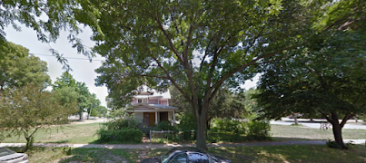
1014 2nd St SE, 2012: Where the Row Houses are now
(Google Earth screenshot)

That space, so close to the city center, was going to be filled with something, though for years what that something would be was up to the viewer's imagination. So it was possible for to look out over an area dominated by bars and hair salons and touristy shops, and imagine an emerging urban village, where a diversity of residents would find all the necessities of life as well as food and entertainment within convenient walking distance. There was a time when it seemed a highly likely outcome. It wasn't there yet, but that was okay, because New Bohemia was very much a work in progress.

Big plans for New Bohemia: 2019 Action Plan, p. 40

It's still a work in progress, and ten years from now it will still be a work in progress, so we are far from pronouncing a final verdict, even as some of that open space gets filled up. Quite a few residential units, mostly apartments and condominiums, have responded to the gap in housing, with more in process or proposed. 
Adaptive reuse:
Water Tower Place Condominiums, 900 2nd St SE
 
 
Compatible construction:
Row Houses on Second, 1008-1018 2nd St SE

The Cedar Rapids Gazette, in one of the last stories by ace reporter Marissa Payne (cited below), listed a number of ideas in circulation for some of the remaining lots in New Bohemia:

900 3rd St SE: Loftus Lumber site under construction by Conlon Construction, to be five-story mixed-used property including 186 market-rate apartments ranging from studio to (two) two-story lofts. [In the Action Plan, the 10th Avenue side is projected to be a "shared space street."]

building under construction
Loftus Building, taken from the Cherry Building

1000 block of 2nd St SE: Conlon Construction proposed a 150-room hotel plus 10 townhomes between 2nd Street and the river, across the street from the Row Houses, on what is now part of a long parking lot. [In the Action Plan, this land is projected for apartments.]

Future hotel site? The federal courthouse is in the background

116 16th Av SE: Darryl High wants to build Vesnice, consisting of one six-story residential building (63 units) facing the river and one four-story mixed use building facing 2nd St with 22 residential units above 1443 sq ft of commercial space. [In the Action Plan, this land is projected for apartments.]

1600 and 1700 blocks of 2nd St SE: Chad Pelley has bought land (from Brett "Bo Mac" McCormick), and intends to purchase additional city-owned parcels on both sides of 2nd Street.

a whole lot of grass, street and buildings in distance
View from the riverside trail of the property under construction, 
New Bo Lofts in the distance

Pelley hopes to build a mixed-use development that's heavy on owner-occupied units. Before he acts, he told the Gazette, "I definitely want buy-in from this neighborhood. What are we missing?" [In the Action Plan, this land is projected for townhouses. 2nd Street will be extended beyond the current cul-de-sac to an unnamed cross street, which will run to 4th Street, past a planned Sinclair Plaza.]
cul-de-sac and grass-covered vacant property
Looking towards the river from the cul-de-sac at the end of 2nd St,
National Czech and Slovak Museum in the distance

Besides these, the Matyk Building, which until recently housed the delightful but financially unsustainable Bohemian (1029 3rd Street SE), is up for sale. Asking price is over $700,000, about double the assessed value. Maybe the hope is someone sees the future value of that land surging? And uses it to build... what? (The only reason I can think of that someone would pay double the assessed value for a property is because they believe it would bring more value with a more intensive use.) 

Matyk Building, 1329 3rd St SE
For sale: Matyk Building

While 1st Avenue East empties out, building and occupying are going gangbusters in New Bohemia. Demand is clearly here, not there. Marissa Payne in the Gazette attributes that to "[t]he NewBo District's arts and cultural scene, entertainment options and a mix of restaurants." Community Development Director Jennifer Pratt told the Gazette: "It is a continuation of what we've seen since the reinvestment after the 2008 flood.... We definitely saw in the market that people were interested in walkable neighborhoods. That has just continued to grow" (Payne 2024).

Friends of New Bohemia are beginning to express anxiety about all the development. A lot of the newest construction has been of the cookie-cutter variety, and some of the proposals are relatively huge. Given that a lot of New Bo's allure relates to its historical character, it should be a no-brainer to insist on compatible form. In the words of the city's Assistant Community Development Director Adam Lindenlaub, "There's an aspect of character that is unique here that you don't see in other parts of the city" (Payne 2024). Beyond that, though, you don't own your view, and when all is working well, the core neighborhoods will be the densest and most valuable in the city.

Inevitably, a lot of the concerns about development in New Bohemia center on parking, particularly for major events. If parking is used by residents, where are the rest of supposed to park? they ask. Sigh. It should no longer be debatable that parking is the enemy of vibe, not to mention wasteful of city finances and land) and no place with plenty of parking is worth visiting (see, for example, Grabar 2023). In this car-dependent city, though, we always imagine ourselves one surface parking lot away from paradise.

Is this heaven? No, but it has a lot of parking!
(New Bohemia on Google Earth, 2019)

And yet, the parking-concerned are not wrong to sense an issue, because New Bohemia has developed in a way that is heavily dependent on traffic from outside, which in the vast majority of cases is going to arrive by personal car. (So has Downtown. Don't even start me on the casino, which the Gazette reports is now Miss America-approved.)

This, then is the real issue: New Bohemia, though still a work in progress, has become a suburb. It is "walkable," to recall Pratt's description, but only for entertainment, and even then walkers must contend with many moving vehicles in search of the same entertainment. Other than that it is a bedroom community. The Czech Village/New Bohemia Main Street District claimed 250 businesses in 2022, but few are significant employers. Schools, groceries, hardware, and pharmacies are far away, and bus service is spotty. There isn't a park (though the west side Greenway will be close by once it's built).

houses under a gray sky
Stoney Point, August 2013: More houses, fewer apartments and bars

The only difference between New Bohemia and, say, the world of Leave It to Beaver, is most of New Bo's housing is multifamily and there are a lot of bars. Maybe too many? The closures of Chrome Horse and Bo Mac's are possibly signs that such an economic monoculture is not sustainable, particularly when bigger newer bars (like Big Grove in Kingston) inevitably come along.

With apologies to Andres Duany, the transect in Cedar Rapids starts with commercial playgrounds in the center, surrounded by a moat of emptiness (MedQuarter, I-380, parking lots for the impending casino); beyond these are residential areas, where getting almost anywhere requires a car. Beyond those are greenfields, waiting to be subdivisions, or part of a wider I-380. Maybe all this was inevitable, but it is indeed regrettable. At least the city should stop subsidizing more of this sort of development.

SOURCE: Marissa Payne, "New Development Coming to NewBo," Cedar Rapids Gazette, 7 September 2024, 1A, 10A

SEE ALSO: "More New, Less Bo?" 4 July 2022

"Where are the Metro's Destinations Heading?" 28 July 2021

"Bridging the Bridge," 26 June 2019

"Envisioning CR I: A 24-Hour Downtown," 1 March 2015

CORRECTION: An earlier version of this post named the former owner of the Matyk Building. It has been updated, with passive voice being used.

Monday, March 7, 2016

What is a form-based code? and other mysteries of zoning

Zoning map from 1920s Winnipeg (Source: Wikimedia commons)

One of the forces that has gotten us into the fix we're in--sprawl-wise and society-wise--is single-use (Euclidean) zoning, which originated over a hundred years ago with the idea of keeping polluting and noisome businesses (factories, slaughterhouses) well separated from where people were trying to live and raise children and such. I don't want to live next to a smokestack anymore than you do, nor do I want to live next to a slaughterhouse, nor when it comes right down to it a baseball stadium or an amusement park. So far, so good.

This laudable beginning, however, led to more dubious efforts to classify and separate. As Andres Duany and his co-authors explain:
This segregation, once applied only to incompatible uses, is now applied to every use. A typical contemporary zoning code has several dozen land-use designations; not only is housing separated from industry but low-density housing is separated from medium-density housing, which is separated from high-density housing. Medical offices are separated from general offices, which are in turn separated from restaurants and shopping. (2000: 10)
Local zoning laws, long helped by federal housing policies, have contributed to the state of the American landscape that is familiar to nearly everyone reading this: large-lot subdivisions located from far from anything anyone does; shopping malls and strips on congested roads; much of the day spent in motor vehicles, stuck in traffic jams or running errands in "Mom's taxi;" a vast sea of parking lots; inner city slums isolated from productive places; the gradual disappearance of third places; and financially-pressed cities and states scrambling to keep up with it all.

Nowadays we know a lot about how these systems work. The public may not be pushing for change: there's a tendency to regard this landscape and the burdens it places as part of the natural order of things, and those with a disproportionate share of economic and political clout may well be glad to be well away from everyone else with all their problems. Duany et al. note: "It has been well documented by Robert Fishman and others how racism was a large factor in the disappearance of the middle class from the center city ("white flight"), and how zoning law clearly manifests the desire to keep away what one has left behind" (2000: 11n).

But there are signs of change. Younger people are showing more interest in urban living, and city governments want to make their places both more appealing and more financially-solvent. Now the same zoning codes which were used to sell development are seen as obstacles. Their rigid rules and formulae restrict individual choice and community adaptation. Whatever to do?

One trend is to wider use of form-based codes. The Form-Based Codes Institute, a non-profit planning organization headquartered in Washington, D.C., defines this concept as
a land development regulation that fosters predictable built results and a high-quality public realm by using physical form (rather than separation of uses) as the organizing principle for the code. A form-based code is a regulation, not a mere guideline, adopted into city, town, or county law. A form-based code offers a powerful alternative to conventional zoning regulation.
In other words, a form-based code focuses on outcomes like the look and feel of a place, rather than on what goes on there. Of course, a community could decide that it prefers the look and feel of a large-lot subdivision, but presumably the motivation to adopt a form-based code would be to seek to achieve an integrated vision not possible with single-use zoning. Cincinnati, Ohio, whose code won an honorable mention from the organization in 2014, provides for a city-wide network of walkable neighborhoods, with standards for building and frontage types, based on the transect (see below), but encouraging neighborhoods to produce their own plans. More recently, three first-ring suburbs of Chicago collaborated on form-based building standards for Roosevelt Road, a highway that runs through all three. In a 1.5-mile stretch, there are pedestrian zones and transitional zones, as well as an auto-oriented zone close to Harlem Avenue, but all emphasize pedestrian safety:
Roosevelt Road form-based code 2014
Roosevelt Road form-based code (swiped from formbasedcodes.org)

The FBCI sites includes examples of codes, webinars and opportunities to register for more intensive conferences.

Communities can consider the natural flow of the transect, which is one way that a form-based code can be organized. The transect is a series of gradual transitions from open/rural spaces to the dense urban center, intended to model a natural transition from, say, seafront to forest. The zones are based on character, form and intensity of development. Basing city zoning on this concept is intended to "provide the basis for real neighborhood structure, which requires walkable streets, mixed use, transportation options, and housing diversity," instead of forcing people to drive great distances to get to separated uses. "The T-zones are intended to be balanced within a neighborhood structure based on pedestrian sheds (walksheds), so that even T-3 residents may walk to different habitats, such as a main street, civic space, or agrarian land."

transect
Source: Center for Applied Transect Studies

The Center for Applied Transect Studies website includes model transect-based codes and modules, as well as--particularly useful for non-planners like me--a photo gallery of examples from the different T-zones. While CATS focuses on municipal zoning, I think this concept would be more relevant to metropolitan regions where there still are natural and rural zones.

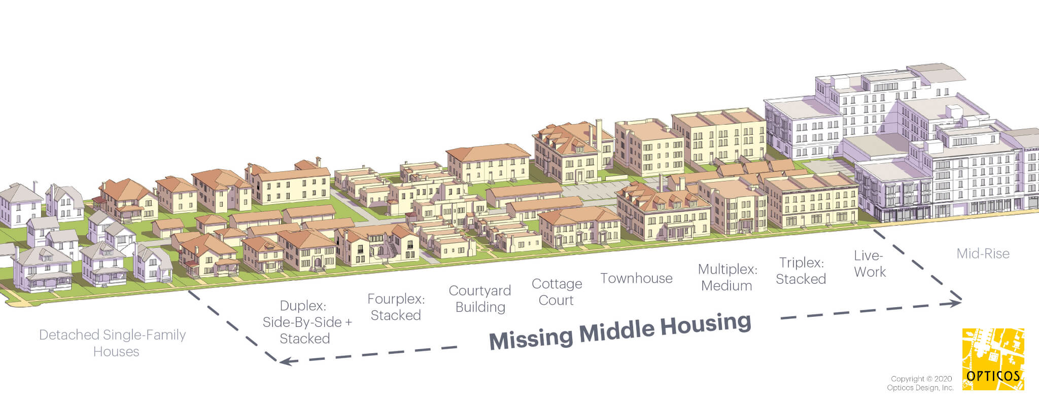
Cities may also seek to encourage development of missing middle housing. Designer Daniel Parolek coined the term "missing middle" to denote "a range of multi-unit or clustered housing types compatible in scale with single-family homes that help meet the growing demand for walkable urban living." These are "missing" because of unmet demand, estimated by Arthur C. Nelson in a 2014 conference paper at 35 million units. Missing middle housing includes duplexes, fourplexes, small multiplexes, bungalow courts, townhouses, courtyard apartments, carriage houses, and apartments-attached-to-workplaces. (See website for examples as well as advice to designers.)
Missing middle housing on the transect
Source: missingmiddlehousing.com

Single-use zoning leads to the lack of such development. Parolek notes: (1) codes usually skip from single-family detached homes to apartment complexes which tend to be large; (2) they don't allow for blended densities; and (3) lack of flexibility in parking and open space requirements discourages smaller units. A form-based code, on the other hand, can create a range of housing types compatible with the community's vision.
Then for each form-based zoning district a specific range of housing types is allowed. For example, in a T3 Walkable Neighborhood a single-family detached type, bungalow court, and side-by-side duplex may be allowed, or a urban T4 Urban Neighborhood zone would allow bungalow courts, side-by-side duplexes, stacked duplexes, fourplexes, and the multiplex: small type, even though the densities of each of these types can range dramatically. Each type has a minimum lot size and maximum number of units allowed, thus enabling a maximum density calculation as the output. (missingmiddlehousing.com)
Cedar Rapids, which lost a lot of housing and commercial buildings to a massive flood in 2008, may have more opportunity than most cities to remake its landscape. Even here, change will come slowly. The main idea is to remove from the law persistent obstacles to traditional, human-scaled development, and where possible to use the zoning code to shape development in the community interest.


WORKS CITED
Andres Duany, Elizabeth Plater-Zyberk and Jeff Speck, Suburban Nation: The Rise of Sprawl and the Decline of the American Dream (North Point, 2000)
Robert Fishman, Bourgeois Utopias: The Rise and Fall of Suburbia (Basic, 1987)
Arthur C. Nelson, "Missing Middle: Demand and Benefits," paper prepared for Utah Land Use Institute conference, 21 October 2014

WEBSITES  
"Center for Applied Transect Studies," http://transect.org/
"Form Based Codes Institute," http://formbasedcodes.org/
"Missing Middle: Responding to the Demand for Walkable Urban Living," http://missingmiddlehousing.com/

JUST PUBLISHED! Ryan Holeywell, "How the 'Missing Middle' Can Make Neighborhoods More Walkable," Urban Edge, 29 March 2016

10th Anniversary Post: One Way or Two?

  Coe Road NE is two-way as of March 2025 Cedar Rapids undertook a number of ambitious street initiatives in the 2010s, including adding bik...