 |
| Zoning map from 1920s Winnipeg (Source: Wikimedia commons) |
One of the forces that has gotten us into the fix we're in--sprawl-wise and society-wise--is
single-use (Euclidean) zoning, which originated over a hundred years ago with the idea of keeping polluting and noisome businesses (factories, slaughterhouses) well separated from where people were trying to live and raise children and such. I don't want to live next to a smokestack anymore than you do, nor do I want to live next to a slaughterhouse, nor when it comes right down to it a baseball stadium or an amusement park. So far, so good.
This laudable beginning, however, led to more dubious efforts to classify and separate. As Andres Duany and his co-authors explain:
This segregation, once applied only to incompatible uses, is now applied to every use. A typical contemporary zoning code has several dozen land-use designations; not only is housing separated from industry but low-density housing is separated from medium-density housing, which is separated from high-density housing. Medical offices are separated from general offices, which are in turn separated from restaurants and shopping. (2000: 10)
Local zoning laws, long helped by federal housing policies, have contributed to the state of the American landscape that is familiar to nearly everyone reading this: large-lot subdivisions located from far from anything anyone does; shopping malls and strips on congested roads; much of the day spent in motor vehicles, stuck in traffic jams or running errands in "Mom's taxi;" a vast sea of parking lots; inner city slums isolated from productive places; the gradual disappearance of third places; and financially-pressed cities and states scrambling to keep up with it all.
Nowadays we know a lot about how these systems work. The public may not be pushing for change: there's a tendency to regard this landscape and the burdens it places as part of the natural order of things, and those with a disproportionate share of economic and political clout may well be glad to be well away from everyone else with all their problems. Duany et al. note: "It has been well documented by Robert Fishman and others how racism was a large factor in the disappearance of the middle class from the center city ("white flight"), and how zoning law clearly manifests the desire to keep away what one has left behind" (2000: 11n).
But there are signs of change. Younger people are showing more interest in urban living, and city governments want to make their places both more appealing and more financially-solvent. Now the same zoning codes which were used to sell development are seen as obstacles. Their rigid rules and formulae restrict individual choice and community adaptation. Whatever to do?
One trend is to wider use of
form-based codes. The Form-Based Codes Institute, a non-profit planning organization headquartered in Washington, D.C., defines this concept as
a land development regulation that fosters predictable built results and
a high-quality public realm by using physical form (rather than
separation of uses) as the organizing principle for the code. A
form-based code is a regulation, not a mere guideline, adopted into
city, town, or county law. A form-based code offers a powerful
alternative to conventional zoning regulation.
In other words, a form-based code focuses on outcomes like the look and feel of a place, rather than on what goes on there. Of course, a community could decide that it prefers the look and feel of a large-lot subdivision, but presumably the motivation to adopt a form-based code would be to seek to achieve an integrated vision not possible with single-use zoning.
Cincinnati, Ohio, whose code won an honorable mention from the organization in 2014, provides for a city-wide network of walkable neighborhoods, with standards for building and frontage types, based on the transect (see below), but encouraging neighborhoods to produce their own plans. More recently, three first-ring suburbs of Chicago collaborated on form-based building standards for
Roosevelt Road, a highway that runs through all three. In a 1.5-mile stretch, there are pedestrian zones and transitional zones, as well as an auto-oriented zone close to Harlem Avenue, but all emphasize pedestrian safety:
 |
| Roosevelt Road form-based code (swiped from formbasedcodes.org) |
The FBCI sites includes examples of codes, webinars and opportunities to register for more intensive conferences.
Communities can consider the natural flow of the
transect, which is one way that a form-based code can be organized. The transect is a series of gradual transitions from open/rural spaces to the dense urban center, intended to model a natural transition from, say, seafront to forest. The zones are based on character, form and intensity of development. Basing city zoning on this concept is intended to "provide the basis for real neighborhood structure, which requires
walkable streets, mixed use, transportation options, and housing
diversity," instead of forcing people to drive great distances to get to separated uses. "The T-zones are intended to be balanced within a neighborhood structure
based on pedestrian sheds (walksheds), so that even T-3 residents may
walk to different habitats, such as a main street, civic space, or
agrarian land."
 |
| Source: Center for Applied Transect Studies |
The Center for Applied Transect Studies website includes model transect-based codes and modules, as well as--particularly useful for non-planners like me--a
photo gallery of examples from the different T-zones. While CATS focuses on municipal zoning, I think this concept would be more relevant to metropolitan regions where there still are natural and rural zones.
Cities may also seek to encourage development of
missing middle housing. Designer Daniel Parolek coined the term "missing middle" to denote "
a range of multi-unit or clustered housing types
compatible in scale with single-family homes that help meet the growing
demand for walkable urban living." These are "missing" because of unmet demand, estimated by Arthur C. Nelson in a 2014 conference paper at 35 million units. Missing middle housing
includes duplexes, fourplexes, small multiplexes, bungalow courts, townhouses, courtyard apartments, carriage houses, and apartments-attached-to-workplaces. (See website for examples as well as advice to designers.)
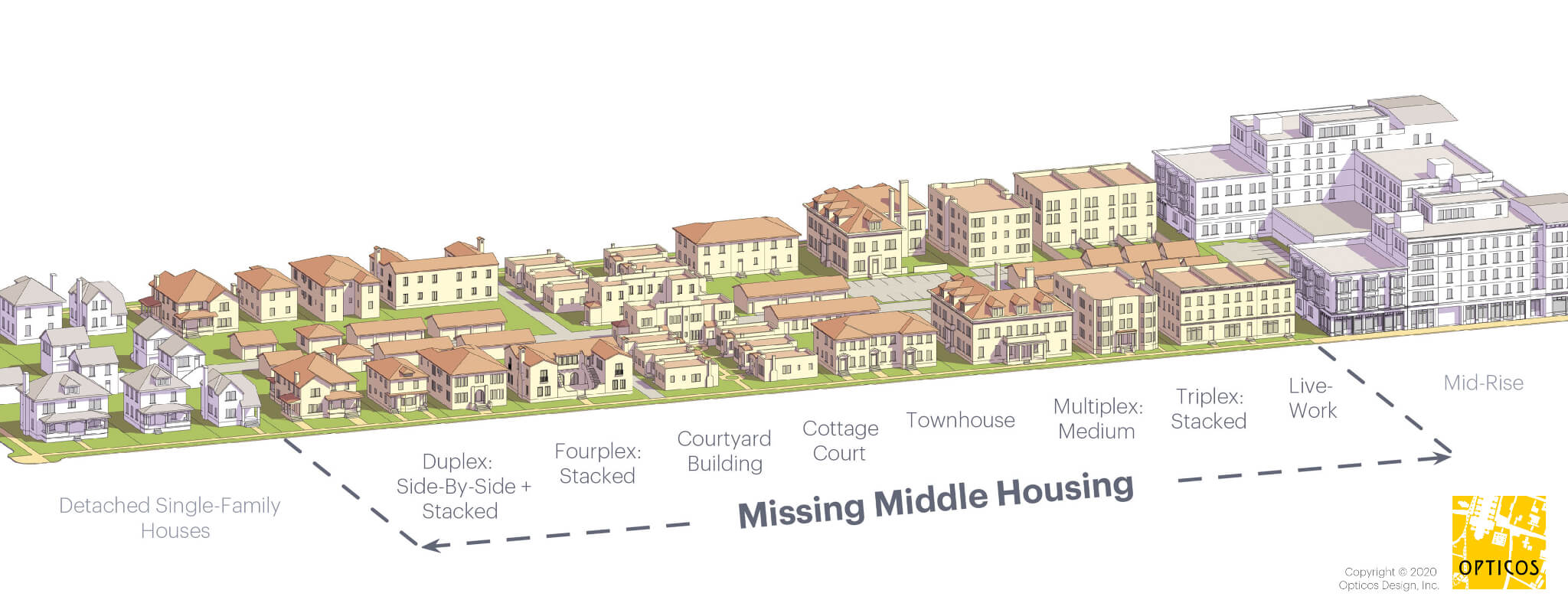 |
| Source: missingmiddlehousing.com |
Single-use zoning leads to the lack of such development. Parolek notes: (1) codes usually skip from single-family detached homes to apartment complexes which tend to be large; (2) they don't allow for blended densities; and (3) lack of flexibility in parking and open space requirements discourages smaller units. A form-based code, on the other hand, can create a range of housing types compatible with the community's vision.
Then for each form-based zoning district a specific range of housing
types is allowed. For example, in a T3 Walkable Neighborhood a
single-family detached type, bungalow court, and side-by-side duplex may
be allowed, or a urban T4 Urban Neighborhood zone would allow bungalow
courts, side-by-side duplexes, stacked duplexes, fourplexes, and the
multiplex: small type, even though the densities of each of these types
can range dramatically. Each type has a minimum lot size and maximum number of units allowed, thus enabling a maximum density calculation as the output. (missingmiddlehousing.com)
Cedar Rapids, which lost a lot of housing and commercial buildings to a massive flood in 2008, may have more opportunity than most cities to remake its landscape. Even here, change will come slowly. The main idea is to remove from the law persistent obstacles to traditional, human-scaled development, and where possible to use the zoning code to shape development in the community interest.
WORKS CITED
Andres Duany, Elizabeth Plater-Zyberk and Jeff Speck,
Suburban Nation: The Rise of Sprawl and the Decline of the American Dream (North Point, 2000)
Robert Fishman,
Bourgeois Utopias: The Rise and Fall of Suburbia (Basic, 1987)
Arthur C. Nelson, "Missing Middle: Demand and Benefits," paper prepared for Utah Land Use Institute conference, 21 October 2014


