 |
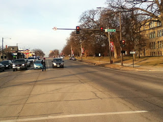
| Looking up 1st Avenue from 6th Street W: The wide street bisects mixed use areas with no safe place to cross |
(8/8/2023) 1st Avenue is unique among the busiest streets in Cedar Rapids because it is not a stroad at the edge of town, but rather plunges straight through the city center. It is the spinal cord of our street network, abutting some of the city's oldest neighborhoods and its best pedestrian infrastructure. It has been the main drag since before there were cars. It was U.S. 151 until 1989, when it became Business Route 151 (Hancock). It draws a lot of vehicle traffic because there really is no alternative street for getting across town; no parallel street to 1st goes for more than a few blocks. Its high vehicle load, frequently turning from side streets or parking lots, and wide design (usually five lanes), create dangerous challenges for pedestrians. I've had a couple of close calls myself.
[At about 18th Street West, the thoroughfare switches onto Williams Boulevard, while 1st Avenue winds through residential neighborhoods for another five miles. We, however, will be looking at the biggest oldest stretch of 1st Avenue through the core.]
Urbanist planner Sean Hayford Oleary asked on streets.mn: Why does walking feel so intuitive when we're in a city built before cars, yet as soon as we return home, walking feels like an unpleasant chore that immediately drives us into a car? He responds to his own question: We don't design the pedestrian experience for dignity. It is hard to find dignity along much of 1st Avenue, and quite a few stretches don't even feel safe to walk along or cross. The city has added some helpful crossing treatments in spots, but others remain problematic. It is not a street I will frequent when my mobility declines.
The title for Oleary's piece for streets.mn begins "If We Want a Shift to Walking..." Do we, though? A wide street carrying most of the vehicle traffic through the center of town is by definition going to be a challenge to cross. And it is quite the challenge, pretty much all along the route, except maybe on Sunday mornings. Past decisions have left us with a series of dilemmas along 1st: how to accommodate both people who use this as a thoroughfare for vehicles, and people in adjacent neighborhoods who need (loaded word, I realize) to access schools, grocery stores, and such across this dangerous street.
Starting on the east side, where I have lived all these years, and with which I am most familiar...
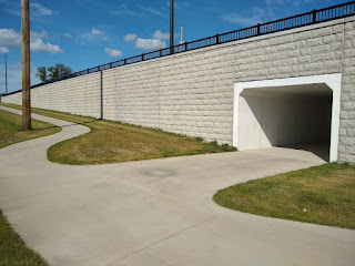
30th Street trail underpass. This was part of a major reconstruction of 1st Avenue a couple years ago. The CeMar Trail will eventually connect Cedar Rapids and Marion, but can also serve as a way for nearby pedestrians to access Walgreen's drug store on the south side or Arthur (soon to be Trailside) Elementary School on the north side, for example.
27th Street. There used to be an overpass here, originating I think to accommodate students walking to Arthur School. Did it get used, or was it too cumbersome to tempt people away from scooting directly across the street?
21st Street/Cottage Grove Avenue. A wide sidewalk was recently added to connect Washington High School, Franklin Middle School, and the CeMar Trail. There's another traffic light at 19th Street, on the other side of Franklin. But it's a long way from 21st to 19th, more than the implied 0.2 mile, and 20th Street is what Franklin is actually on. Crossing there could definitely be improved.
.png) |
| Crosswalk across slip lane merging 19th Street SE onto 1st Avenue (Google Earth screen capture from 2021) |
19th Street. We're getting into some serious core now. 19th Street SE forms the eastern boundary of Wellington Heights, while 20th Street NE forms the eastern boundary of Mound View. Crossing is made more dangerous by the slip lane moving traffic from 19th Street SE onto 1st Avenue. On a brighter note, 1900 1st Avenue is slated to be a Dunkin' Donuts, which is less pedestrian unfriendly than the gas station/convenience store proposed last year.
 |
| Park Court at 1st Avenue, July 2014 |
16th Street/Park Court. 16th Street NE has the traffic light where it ends in a t-intersection with 1st Avenue, next to the Hy-Vee grocery store which was slated to close in 2000 before $1 million from the city kept it open to serve the surrounding neighborhoods. The city missed the chance back then to move the storefront to at least one of the streets, and to rectify the pedestrian crossing at 1st which frustrates drivers and pedestrians alike. (On the southeast side, both 16th Street SE and the much-traversed Park Court end at 1st Avenue without crossings; pedestrians are directed to the traffic light half a block away, which not all of them follow. In 2020 I proposed rerouting 16th Street to give people coming from the southeast side a straight shot to the grocery store.)
 |
| College Drive/13th Street E, April 2014 |
 |
| Removing one-left turn lane in 2021 improved traffic flow and pedestrian safety (Google Earth screen capture) |
13th Street/College Drive. Both crossings by Coe College have been considerably improved, though they remain risky. Before 2021 there were two left turn lanes on 1st, dating I think from the time before I-380 when traffic was routed onto certain two- or three-lane one-way streets (including the street that is now College Drive). It's still a long way across 1st Avenue from campus to the apartments or the cafe on the corner (opening soon!), but there are fewer rows of cars to cross, and since left-turning cars can now turn at any time during the green light instead of having to wait for the green arrow, the drivers are likely to be less desperate.
 |
| Coe Road/12th Street E, September 2013 |
12th Street/Coe Road. At 12th, where Coe sits across from Casey's convenience store and Via Sofia's restaurant,...
 |
| Coe Road/12th Street E, July 2023 |
...the right turning radius has been tightened, and a walk button and striped crosswalk have been added.
10th Street. This is the main street of the MedQuarter, with medical facilities on both sides of 1st Avenue, and has a bus stop and some fine-looking crosswalks. A car came at me in one of those crosswalks a few weeks ago, and I had to scramble out of the way. A police officer saw it all from his car. I made eye contact. The officer made eye contact. Later I found out it's not technically against the law to nearly-hit someone.
8th Street and 7th Street. Twin one-way streets that are the main ways to access and egress I-380 from the east side of downtown. Wherever you cross this intersection, be extra careful, especially when crossing right-turn lanes.
.JPG) |
| 4th street trail crossing, May 2014 |
4th Street. This is where the Cedar River Trail crosses 1st Avenue near downtown, right by the hotel/entertainment complex the city bought ten years ago. I have never been comfortable crossing here, but recent work has definitely improved it.
 |
| 4th street trail crossing, May 2023 |
There are more and better flashing lights, now at driver's eye level, and there's a median in the middle of the street so you're not taking on all four lanes at once.
 |
| 1st and 1st project under construction |
1st Street W. The Kingston area on the southwest side has seen explosive development since the 2008 flood and subsequent. Land that had been cleared for a casino is being developed as a hotel, brewery, pickleball court. Other attractions, unfortunately including the inevitable casino proposal, may follow. This intersection is likely to be quite the hotspot, particularly if we anticipate people visiting more than one place. A key crossing light has been added between 1st and 3rd Streets W for when pedestrians can access this area again.
 |
| L Street NW spills off the highway and onto 1st Avenue (not pictured is a really nice sidewalk on that side of 1st, leading to that intersection) |
3rd Street and L Street. Twin one-way streets that are the main ways to access and egress I-380 from the west side of downtown. Wherever you cross this intersection, be extra careful, especially when crossing right-turn lanes.
 |
| a wee median but no crosswalks by St. Patrick's Church, 5th Street W |
5th Street. Past the interstate 1st Avenue is back to cleaving older neighborhoods, on this side the Taylor Area in the southwest quadrant and Time-Check in the northwest. As on the east side, crossing from one neighborhood to the other is serious business I would not encourage either an 8-year-old or an 80-year-old to undertake. 1st Avenue got some serious working over between the river and 6th, but there will still be six lanes in front of this parish church--seven on the other side of 5th--without much help to cross them.
 |
| crosswalk at 6th Street W |
6th Street. For many years 6th Street has been a main thoroughfare through the near southwest side--it goes all the way to Coralville!--but a short side street on the northwest side. Most excellently, the city has just punched it through to connect with Ellis Boulevard NW, which should lead to some good things. It will be interesting to observe the evolution of this intersection. There are a bunch of small restaurants and bars around here, as well as some ethnic groceries, that could benefit with more pedestrian traffic, but that will only happen if it's safe to walk.
"What is a 'Stroad?'" 3 April 2014
"Figuring Out a Dangerous Intersection," 24 September 2013
"Walking Down to the Edge of Town," 2 August 2013


No comments:
Post a Comment