Tuesday, August 14, 2018

Bypasses and suburban development


(Video: US 30 construction from Cedar Rapids Gazette)

Two substantial highway projects are underway in Linn County: extension of Iowa 100 around the northwestern side of Cedar Rapids, and diversion of U.S. 30 to the south of Mount Vernon and Lisbon. With total federal and state commitment in the mid-nine figures, it’s worth asking what impact these projects will have on our towns? With widening Interstate 380 between Cedar Rapids and Iowa City also still a live option, what does all this rural concrete say about the vision for our future?

These bypasses will have different effects than the bypasses around small towns I surveyed in my last post. Those moved through traffic out of the center of town, but besides that had no immediate effect, either positive or negative, on the towns themselves. In Linn County we’re dealing with one entirely new road, and one replacement for an existing two-lane bypass. Moreover, we’re dealing with them in Iowa’s second-largest county, one that has seen 17 percent population growth since the 2000 census (average for the U.S., but much faster than the whole State of Iowa). The Cedar Rapids metro area presents a more dynamic context than do the towns in the last post; so, given that change is already happening and ongoing, what will the bypasses contribute to it?

Commercial strip on Bus US approaching 151/13 bypass (Google Earth)
Officials in each town anticipate the bypasses will accommodate, indeed will facilitate, future growth. (The population density of the city of Cedar Rapids is a modest 1,189/sqmi, but we do like our personal space.) Cedar Rapids projects a 2035 population of 161,073, assuming 1 percent annual growth, a gain of 29,000 from the current estimate of 132,228 (EnvisionCR 54). Cedar Rapids's future land-use map anticipates the area around the new highway to be a mix of commercial and "urban medium-intensity" characterized by 4-12 units per acre, a "high-connectivity grid pattern" and "transportation, housing and shopping choices in close proximity to each other" (EnvisionCR 69). 
Future land use map including areas to be annexed (Envision CR 67)
Mount Vernon's map shows a mix of "suburban residential," "general commercial," and "business park."
Future land use map including areas to be annexed (cityofmtvernon-ia.gov)
Lisbon is still working on their map, but they too are bullish on the town’s expansion. City Administrator Connie Meier told the Gazette: We’re hoping to grow the community by having developments up to the bypass, hopefully on the east side of town and south of town, and also incorporate some commercial business along the bypass (Payne 2018: 11A).

The most likely outcome of federal-state highway spending and local growth ambitions is suburban sprawl, by which I mean low-density, car-dependent, loosely-controlled expansion into unsettled areas. Here’s why:
((1)) The new and expanded highways will induce demand, but even so the areas available for expansion would accommodate growth beyond the most optimistic projections. Eyeballing, the area around Highway 100 adds about 20 percent to the Cedar Rapids current area; at current density that would add over 26,000 residents. Mt. Vernon expects to spread not only to the new U.S. 30, but southward along S.R. 1, and as new U.S. 30 swings south it provides Lisbon with plenty of room to grow. So I'll say to fill up all three areas even at low suburban densities would take at least 30,000. That's nearly double the three towns' combined growth between 2000 and 2016, and equals the optimistic growth projection for Cedar Rapids alone. Development is going to be low-density here, and unless economic development and demand for labor ramps up in a hurry, the newly-opened areas will add residents by competing for existing residents with other parts of the county. 

((2)) Because development will occur before annexation, the future land use maps are merely suggestive. This limits their influence on the nature of development, for all that Mt. Vernon city administrator Chris Nosbisch tells the Gazette "it's imperative" for the new commercial area by the bypass to fit with what the town already has (Payne 2018: 11A; see also Kalk 2018). Town leaders ravenous for “game-changers” will accept whatever’s done.

Newer suburban development south of U.S. 30, Lisbon (Google Earth)
((3)) Previous bypasses, like Iowa 13 east of Cedar Rapids or U.S. 30 to the south, have produced exactly this kind of development. Exits off U.S. 30 in Cedar Rapids lead to the miles of big-box stores and commercial strips along Edgewood Road, Williams Boulevard and other "stroads" in that area, with characteristic swaths of pavement and low tax yield per acre. Entering Marion off Highways 13/151? Same. Residential developments around these highways are either large-lot subdivisions or mobile-home complexes, and never both. (The latter are, admittedly, densely-populated, but in a way that's more efficient for the owner than walkable for the residents). Public transit out here is scanty where it exists at all. The current two-lane, non-limited access U.S. 30 south of Mount Vernon and Lisbon mostly features a typical highway commercial strip of gas stations, fast food and car dealers.

((4)) While the last decade has shown some impressive appetite for walkable urbanism living, particularly among younger consumers and empty-nesters, gasoline is too cheap, commutes too short, and the environmental consequences too remote for this preference to expand enough to reshape our development pattern.

((5)) It’s what developers want to build anyway (Samuels 2015).

Edgewood Road SW, looking towards U.S. 30

The negative consequences of the suburban development pattern have been thoroughly catalogued (for example, in these older essays, "Urbanism Review" and “The Urbanism CLEF”). Inducing more driving stresses the environment, the school system and the local economy. The arterial stroads typically used to funnel traffic through populated areas to the highways have seen the greatest increase in pedestrian deaths ("On Foot, At Risk" 2018). An increasing pile of studies have shown negative health impacts of sprawl (Jackson and Kochtitzky 2009). Sure, Cedar Rapids, Lisbon and Mt. Vernon can use the property tax revenue, generated by anticipated new development around the highways, to fund existing services and older parts of their towns. However, like the energy from a sugar buzz, this can’t last forever, and in the meantime will largely be spreading out the metro area population. Given the proclivity of all three towns to expand in low-density, auto-centric ways, this is not good news; in the long run suburban development over-extends the cities' financial capacity (Marohn 2011). Annexations rarely pay for themselves after the initial infusion of property tax revenue (Nielsen 2018).

The solution to ongoing suburban development probably needs to be cultural change, and depending on who you read and how alarmed they are, the impetus for that may be closer than we now think. In the meantime, we could use a regional governmental entity for Linn and Johnson Counties that has the resources to do long-term planning, make the public case for policies designed for resilience, manage and possibly even limit urban growth, and which shares revenues among all the local governments so that they don’t feel the need to pursue separate sugar buzzes to the detriment of the whole (see also Peter Calthorpe and William Fulton, The Regional City: Planning for the End of Sprawl [Island, 2001]).

A resilient city is prepared when current conditions--cheap gasoline, new infrastructure that can go maintenance-free for a while, ready access to federal money, a booming economy--change. Suburban commuting is the opposite of resilient, draws resources away from the city particularly poorer residents, and draws open land and resources away from the natural environment. Sprawling our way into the future is not the way to go.

Tuesday, August 7, 2018

Bypasses and the towns they bypass

US 30 bypass under construction south of Mt. Vernon
and Lisbon (Google Earth) 
As construction on the U.S. 30 bypass around Mt. Vernon and Lisbon nears the paving phase, and parts of the Highway 100 extension around the northwest side of Cedar Rapids already are open for traffic, hopes are high in all three towns for the development they will bring. "We're hoping to grow the community by having developments up to the bypass, hopefully on the east side of town and south of town, and also incorporate some commercial businesses along the bypass," said Connie Meier, city administrator for Lisbon, which is 18 miles east of Cedar Rapids (Payne 2018: 11A).

Recent experience shows building a bypass is no guarantee a town will grow. Bypasses have been burgeoning around the state longer than roundabouts have. As this survey of recent bypasses shows, Iowa towns have tended not to expand to meet the bypasses, nor has much if any development occurred along the new highways. The bypasses have taken traffic pressure off the city's main streets, but walkable urban development has not resulted. No town has seen burgeoning population growth, and a few have declined.

Cascade (Dubuque County, partly in Jones County)
Population (2000): 1,998
Population (2016): 2,281
Increase 2000-2016: 283 (+14.2%)
Land area: 1.87 sq mi
Distance to Dubuque: 25 miles
ADTC of 1st Ave at Johnson St (2001): 6700 (w)-9100 (e)
ADTC of 1st Ave at Johnson St (2013): 2460 (w)-4650 (e)
What's on US151 today: small manufacturing facilities, church, auto dealership
What's on 1st Ave (old US151) today: residential, some commercial... 1st and Johnson features a Subway restaurant, bank, service station and used car dealer.
Assessment: Cascade has not expanded to the highway. Traffic on Johnson Street (S.R. 136) has declined but only slightly.

Clinton (Clinton County)
Lyons Business Tech Park
Lyons Business and Technology Park, off Mill Creek Parkway,
has started slowly (Source: City of Clinton)
Population (2000): 27,792
Population (2016): 25,719
Decrease 2000-2016: -2,073 (-7.5%)
Land area: 35.15 sq mi 
ADTC of Mill Creek Parkway (2014): 4830-8100
What's on Mill Creek Parkway today: Wild Rose Casino and Hampton Inn near US 30, and some commercial development at 19th Avenue, as well as a few churches.
Assessment: Mill Creek Parkway, opened in 2001, is not a complete bypass, just an access road along the western edge of Clinton that ends at Main Avenue. There has been very little change 1998-2014 on traffic on the existing diagonal route (Bluff/Manufacturing Dr) or on US30 towards downtown. Some subdivision development near parkway. Neither parkway nor casino has dramatically impacted residential pattern or town's economy. In September 2017 the City of Clinton announced they would apply for a federal grant to widen the parkway to four lanes as well as extending it to Eagle Point Park (Mosbach 2017).

Monticello (Jones County)
Population (2000): 3,641
Population (2016): 3,836
Increase 2000-2016: 195 (+5.3%)
Land area: 6.29 sq mi
Distance to Cedar Rapids: 35 miles
ADTC of Main St at 1st St (2001): 7300 (n)-11000 (s)
ADTC of Main St at 1st St (2013): 3960 (n)-6900 (s)
What's on US151 today: service station, pizza chain
What's on Main St (old US151) today: residential, some commercial... Main and 1st features two bakeries, Mexican restaurant, regional chain pharmacy.
Assessment: Highway bypass is mostly within Monticello corporate limits but residential and commercial development has not expanded to the highway. Traffic on 1st and Cedar Streets (S.R. 38) has significantly declined.

Mount Pleasant (Henry County)
https://cityofmountpleasantiowa.org/wp-content/uploads/2018/05/jefferson-ave.jpg
North Jefferson Street (Source: City of Mt Pleasant)
Population (2000): 8,761
Population (2016): 8,392
Decrease 2000-2016: -369 (-4.2%)
Land area: 8.51 sq mi
Distance to Burlington: 30 miles
ADTC of Grand Ave at Washington St (1998): 6500 (s)-9500 (n)
ADTC of Grand Ave at Washington St (2014): 3230 (s)-7900 (n)
ADTC of Washington St at Grand Av (1998): 12800 (e)-13700 (w)
ADTC of Washington St at Grand Av (2014): 11600 (e)-10800 (w)
What's on US218/34 today: Few interchanges. Only considerable commercial development at Washington Street exit; not sure how much is new.
What's on Washington St (old US34) and Grand Av (old US218) today: More commercial on Washington than on Grand, mostly franchise chains and discount stores. Intersection of Washington and Grand retains elaborate auto-oriented diamond interchange which prevents development of any kind there.
Assessment: Highway bypass is partly within Mt. Pleasant corporate limits, but residential development has not expanded to the highway. The Mt. Pleasant Trail runs along the 218 bypass east of town. Some loss of traffic on some parts of former US routes but not all, which is curious. Traffic on other major streets (Cherry, Jefferson) is mostly unchanged. A Main Street group exists which may serve to promote urbanism in the town's core.

New Hampton (Chickasaw County)
Population (2000): 3,711
Population (2016): 3,424
Decrease 2000-2016: -287 (-7.7%)
Land area: 3.16 sq mi
Distance to Waterloo: 40 miles
ADTC of Linn Ave at Main St (2001): 7200 (n)-7500 (s)
ADTC of Linn Ave at Main St (2013): 3320 (s)-3890 (n)
What's on US63 today: Commercial and industrial development at Milwaukee Street interchange does not appear to be new: closest to the highway is Klunder's Kafe, opened in 1981.
What's on Linn Ave (old US63) today: residential, schools, some commercial including locally-owned. Linn and Main features a hair salon, Clark Contract Services office, wheelchair and stretcher store, and elementary school.
Assessment: New Hampton has not expanded to the highway, except for a ready-mix concrete business that opened west of the bypass five years ago. Traffic on Main Street (S.R. 24) has substantially declined.

Tama/Toledo (Tama County)
Highway 30 bypass through Tama County (Source: Tama County)
Combined population (2000): 5,298
Combined population (2016): 5,018
Decrease 2000-2016: -280 (-5.3%)
Combined land area: 5.56 sq mi
Distance to Waterloo: 45 miles
ADTC of old US30 at Park St (2001): 6700 (e)-9000 (w)
ADTC of Business US30 at Park St (2013): 3470 (e)-4610 (w)
What's on US30 today: Substantial commercial strip on Park Street (US63) predominantly franchise chains and discount stores, does not appear to be new.
What's on Business US30 today: Primarily an access road in Tama; some commercial development along frontage roads in Toledo. Intersection of Business 30 and Park retains auto-oriented interchange which prevents development of any kind there. Some effort gets you to Hardees' and Maid-Rite fast food restaurants, an auto dealership, and a Casey's Convenience Store.
Assessment: New highway runs between Tama and Toledo rather than completely around the communities, which required running it through a small subdivision where several streets have been dead-ended. Traffic on US63 (Park Street in Toledo, Harding Street in Tama) has significantly declined.

In nearly all of these cases, the bypass reduced traffic through the downtown areas. This could be a bad thing, because fewer people are driving past the town's businesses. If businesses move near the new highway, it could lead to auto-centric "stroad" building at the edges of town.

The bypass could also be a blessing, since it means the main street can serve as a town center without also having to be a thoroughfare for long-distance traffic. This would encourage businesses that are oriented to the place rather than the convenience of the long-distance drivers (e.g. more groceries, hardware stores, restaurants and coffee shops instead of convenience stores and fast food franchises).

In fact, construction of the bypasses has had few noticeable impacts of either a positive or negative nature on these towns. They haven't generated a great deal of auto-oriented development at the edges, nor has the space they have created led to walkable urbanism in the town centers (though time may tell a different story, particularly in Mt. Pleasant). Cascade and Monticello have added population, while the other towns have lost population, but in relatively small amounts either way.

The bottom line is that bypasses are good for what they're designed to do, facilitate the movement of long-distance traffic. Towns can hope they'll also facilitate development of one kind or another, but on that score the recent record is unimpressive. Cedar Rapids, Lisbon and Mt. Vernon might argue that in an urban county population increases will fuel development in the newly-opened spaces, and they might be right. On the other hand, Route 13 was built around the east edge of Cedar Rapids and Marion in the 1960s, and widened to four lanes in the 1990s (Hancock 2018); development has been slow and limited (and heavy on the auto-oriented commercial).

EXTRA FUN NOTE: A new feature of Google Earth allows time lapse views of places. Watch the bypasses appear!

Thursday, August 2, 2018

When are roundabouts indicated?

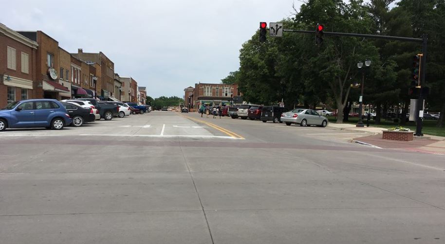
Strange intersection north of Coe College campus. Is a roundabout the solution?
Construction of roundabouts is "exploding" around the State of Iowa, according to Steve Gent, who is director of traffic and safety for the Iowa Department of Transportation (Morelli 2017). Cedar Rapids recently got into the game with a redesigned intersection of Kirkwood Boulevard and 76th Avenue SW, and will soon get two more on Johnson Avenue SW. All these roundabouts come with many promises of improved traffic performance, and much public angst about the introduction of this unfamiliar traffic feature. Our task today is to decide when roundabouts might be a positive addition, and where they might be overdone.

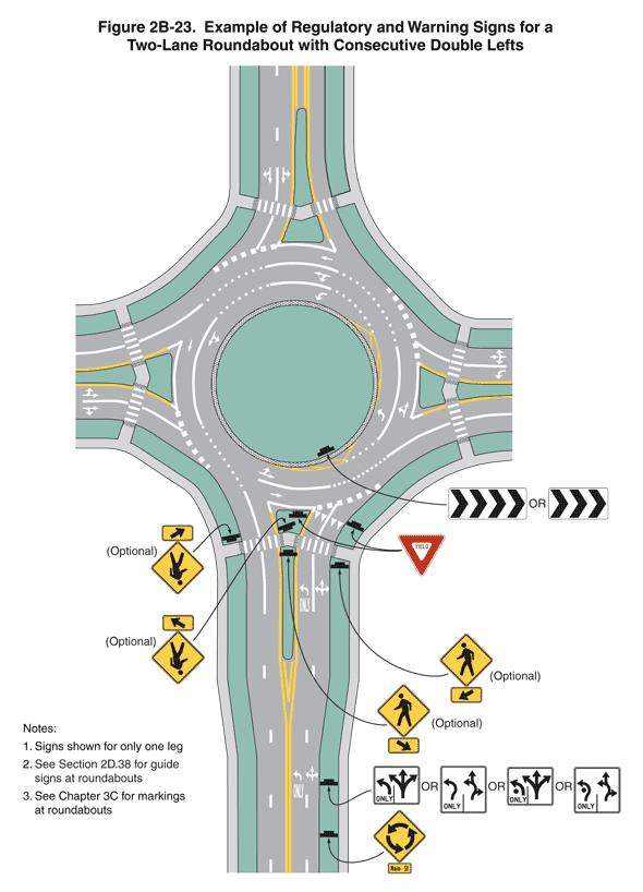
Roundabout schematic (Source: U.S. Dept of Transportation)
A roundabout is a circular intersection characterized by small diameters (relative to traffic circles like Columbus Circle and DuPont Circle in Washington, D.C.); curvature designed to slow speeds; a center island around which traffic turns; and the requirement for entering drivers to yield to those already in the circle (USDOT 2000: 5). Conceptual or real operation can be seen in the videos listed below. Benefits of roundabouts include:
  • improved traffic flow despite slower traffic speeds, because vehicles are moving at a slow steady pace instead of alternating stopping and going fast;
  • less pollution, at least at the intersection site, because the cars keep moving;
  • improved safety because there are fewer contact points and all cars are going in the same direction; 
  • lower year-to-year costs than a traditional signal because those require electricity and maintenance (though construction costs are higher).
St. Paul, MN: Intersection of Charles and Albert Sts is more properly called a "neighborhood traffic circle"

The disadvantages of roundabouts stem from their unfamiliarity in much of this country, outside of the Northeast. Drivers' uncertainty can create more problems than the feature is designed to solve, particularly in a two-lane roundabout where the required lane changes seem to guarantee mass confusion (see second diagram here). Tom Vanderbilt argues that's a feature, not a bug:
With a roundabout, only a fool would blindly sail into the scrum at full speed [as opposed to the common maneuver of speeding through a yellow light]. Drivers [entering a roundabout] must adjust their speed, scan for openings, negotiate the merge. This requires more workload, which increases stress, which heightens the feeling of danger. This is not in itself a bad thing, because intersections are, after all, dangerous places. [From the previous page: 50 percent of all road crashes occur at intersections.] The system that makes us more aware of this is actually the safer one. (2008: 179)
Cultural hostility to change, whether it involves sidewalks or LED light bulbs or the metric system, gets magnified when it hits us where we live, and a lot of us live in our cars. Elected officials are understandably chary of triggering this hostility. Additionally, there is the cost of conversion, estimated at $1.2 million (Morelli 2017), which is about four times the cost of installing a set of traffic signals, and way more expensive than a four-way stop. Finally, there is disagreement over whether bicyclists and pedestrians benefit from this design.

Newly-built intersection of 5th St and 16th Av SW includes a roundabout:
anticipation of future traffic, or vanity feature?
Roundabouts and traffic circles are commended as traffic calming measures in David Sucher's manual for city-building. He explains:
[Roundabouts are] not so much to slow down traffic but to allow movement through intersections without having to stop.... A slow but steady pace would achieve the same overall time from origin to destination but without the mental aggravation of continual acceleration, braking, stopping, and then accelerating again. (2003: 79; see also Vanderbilt 2008: 124)
He cautions, however:
The traffic circle is not manna. Some drivers loathe them and will change their route to avoid them, which may serve to decrease traffic on one block, only to divert it to another, increasing traffic there. (2003: 78)
The main trick with roundabouts is to keep traffic flowing without creating disconnection between the parts of the city on either side. From this we might conclude that roundabouts are indicated where traffic volume is great enough to overwhelm a four-way stop; the volume of turning traffic would require a separate turning light, making the overall light cycle painfully long; and pedestrian and bicycle traffic is manageable. There should be regular breaks in the traffic, so that new entrants can merge easily--unlike Chevy Chase's experience in "National Lampoon's European Vacation!"--pedestrians can get through the intersection in a timely fashion, and cyclists can cycle.

[The Iowa Drivers Manual (cited below) recommends "Generally, cyclists should walk their bicycles across the pedestrian crosswalk using the same rules as pedestrians," though it allows that "Experienced cyclists may navigate roundabouts like motorists." If the traffic feature in an area with significant bicycle traffic depends on cyclists getting out of the way, it is doomed to failure. The idea of urban design is that it accommodates and channels normal human behavior, rather than presuming that one set of travelers is voluntarily going to withdraw from the scene.]

Pair of roundabouts on U.S. 30 south of Mt. Vernon (Google maps)
On roads roundabouts can be focused on traffic flow. One successful roundabout near Cedar Rapids is at the intersection of U.S. 30 and S.R. 1 in Mt. Vernon. It used to be a four-way stop, featuring long backups at most times of the day. With the roundabout we sail right through, though I confess I haven't tried it during rush hour. There's another roundabout to the west where U.S. 30 intersects 10th Street. When I drive through, it seems unnecessary because of the lack of traffic off 10th Street. I understand that traffic occurs mainly at school drop-off and pick-up times, and that there had been a substantial number of crashes there. I don't know that the roundabout was the best solution--maybe cars needing to go east on U.S. 30 could have been guided to S.R. 1--but I don't know that it wasn't. A student from Mt. Vernon reports that every member of the City Council who voted for the roundabouts was defeated at the next election, which speaks to the fraught political climate around this issue. The American Society of Civil Engineers reports the outcome eventually got happy; they quote Justin Campbell, a transportation engineer on the project: Now that the roundabouts are finished and working, people are happy. The cars are moving (Wilcox 2016).


Other than the ones on U.S. 30, the Linn County roundabout that gets the most use is unquestionably the one west of downtown ("Uptown") Marion, at the intersection of 7th Avenue, 7th Street, and 6th Avenues. (An indication of the current rage for roundabouts is that an Internet search for "Marion roundabout" finds stories from Illinois, Indiana and Kansas as well as Iowa.) It opened November 2016 as part of Marion's Central Corridor Project, intended to divert through traffic off 7th Avenue onto 6th and allow 7th to become the hub of a walkable urban district (Kasparie 2016). It is no longer possible to go through the intersection southbound on 7th Street, or westbound on 6th Avenue, though it's not clear how many people were previously doing this.

Traffic moved briskly through the roundabout this morning while I observed it from 7:45-8:30 a.m. Most people drove with confidence, even though the feature is barely a year and a half old. There occasionally appeared to me to be hesitation entering the circle, but nothing that delayed traffic more than a few seconds. Only one driver was yielding to traffic entering the circle, and two drivers--both talking on phones--were observably erratic.

Most traffic this morning was headed west along 7th Avenue i.e. towards Cedar Rapids, and I saw the only mild backups on westbound 7th approaching the roundabout, a string of six and a string of seven cars behind semi-trucks that had had to stop before entering the circle. There was more traffic on 7th Avenue than on 8th Avenue, so no evidence that traffic was diverting away from the roundabout. I'd heard reports from a local student that backups occasionally occurred when a line of cars proceeded north on 7th Street and had to stop at 8th Avenue...
...but I never saw more than one car going in that direction this morning. Country Kitchen Cafe was doing a brisk business on the southwest edge of the circle...
...though I'd be interested to compare their before-and-after numbers. Very few pedestrians or cyclists came through while I was observing. The cyclist used the sidewalks and surprised a driver when he turned left across 7th Street. Few eastbound cars bypassed the commercial area on 7th Avenue by diverting to 6th Avenue, but 6th isn't yet complete around Uptown. Overall, I'd say traffic was moving, quite likely better than it did when the intersection was governed by a set of traffic lights.

So, bottom line: Should the complex intersection north of Coe (pictured at top) be redone as a roundabout? It would certainly facilitate conversion of the streets to two-way, and would seem not to stand in the way either of better development of the area, or of increased pedestrian activity. Here would be something that's broken, and a roundabout would be one, perhaps the best, way to fix it.

VIDEOS
Bicycle Dutch, "A Bicycle Roundabout in Boxtel (Netherlands)," (YouTube, 3:16)
City of Cedar Rapids IA, "Simulation Video of Johnson Avenue NW Roundabouts" (YouTube, 1:29)
Insurance Institute for Highway Safety, "How Roundabouts Work" (YouTube, 2:00)
Charles Marohn, "Pimped Out Roundabout" (YouTube, 2:51)
Thorsten Peters, "Laweplein 02" (Vimeo, 1:47)

SOURCES
"Hans Monderman's People-Friendly Dutch 'Squareabout,'" ThinkBicycling, 13 June 2013
David Hembrow, "Where the Crashes Are: Shared Spaces and Other Poor Junction Designs Which Don't Protect Cyclists Lead to Crashes and Injuries," A View from the Cycle Path, 7 April 2014
Jill Kasparie, "Marion Prepares for Work to Begin on Roundabout Projects," KCRG.com, 15 March 2016
B.A. Morelli, "Cedar Rapids Gets Its First Roundabout as Traffic Tool 'Explodes' Around Iowa," Cedar Rapids Gazette, 9 June 2017
David Sucher, City Comforts: How to Build an Urban Village (City Comforts, rev. ed., 2003)
U.S. Department of Transportation, Roundabouts: An Informational Guide (USGPO, 2000)
Tom Vanderbilt, Traffic: Why We Drive the Way We Do (and What It Says About Us) (Alfred A. Knopf, 2009)
Kevin Wilcox, "Iowa Roundabouts Go with the Flow," Civil Engineering, 12 April 2016

And finally...

...because I've been humming it the whole time I've been writing!

Justice in the World Today

  Hope he gets some of that coffee: Statue of Thucydides in Vienna, Austria (7/31/2026)  A long time ago, according to the ancient Greek his...