Thursday, June 20, 2024

High hopes for new Westside library


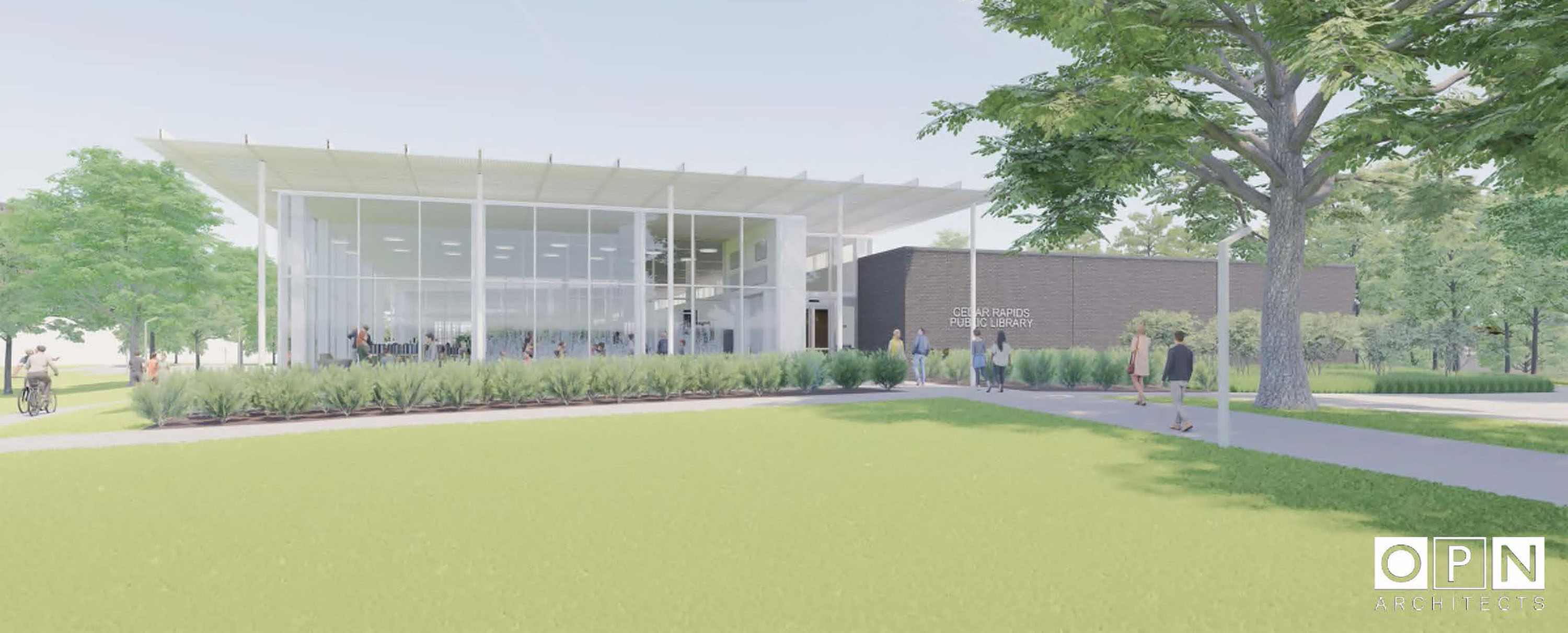
proposed Westside Library
Proposed Westside Library (from crlibrary.org)

The Cedar Rapids Public Library plans to open a new west side location in late 2026, on 27 acres of land purchased with a recent estate gift. The new building will replace the Ladd Library, which is located in a former Target store on Williams Boulevard SW. At a reason information session, Executive Director Charity Roberts Tyler explained the library is committed to serving the growing low-income neighborhood around the Ladd location. The project will go out for bid shortly, with groundbreaking expected in the fall, even as fundraising from public and private sources continues. The accelerated timeline is necessitated by the impending end of the Ladd Library lease.

field across a road will be a library
Westside Library site now, from across 20th Ave SW

The library cites the immediate area's population growth as one factor in favor of the new facility. The new facility, like the Ladd Library, will be located in Census Tract 10.05 (which was part of tract 10.03 before 2020). Despite being about 3.5 miles from downtown, 10.05 and its next-door neighbor 10.04 are among the metro's tracts with the highest population density. They are among the lowest rates of owner-occupied housing and single-family homeownership, and among the highest in percent black and percent Hispanic. They arguably suffered the most damage from the 2010 derecho.

apartments on narrow street
Apartments across 20th Avenue

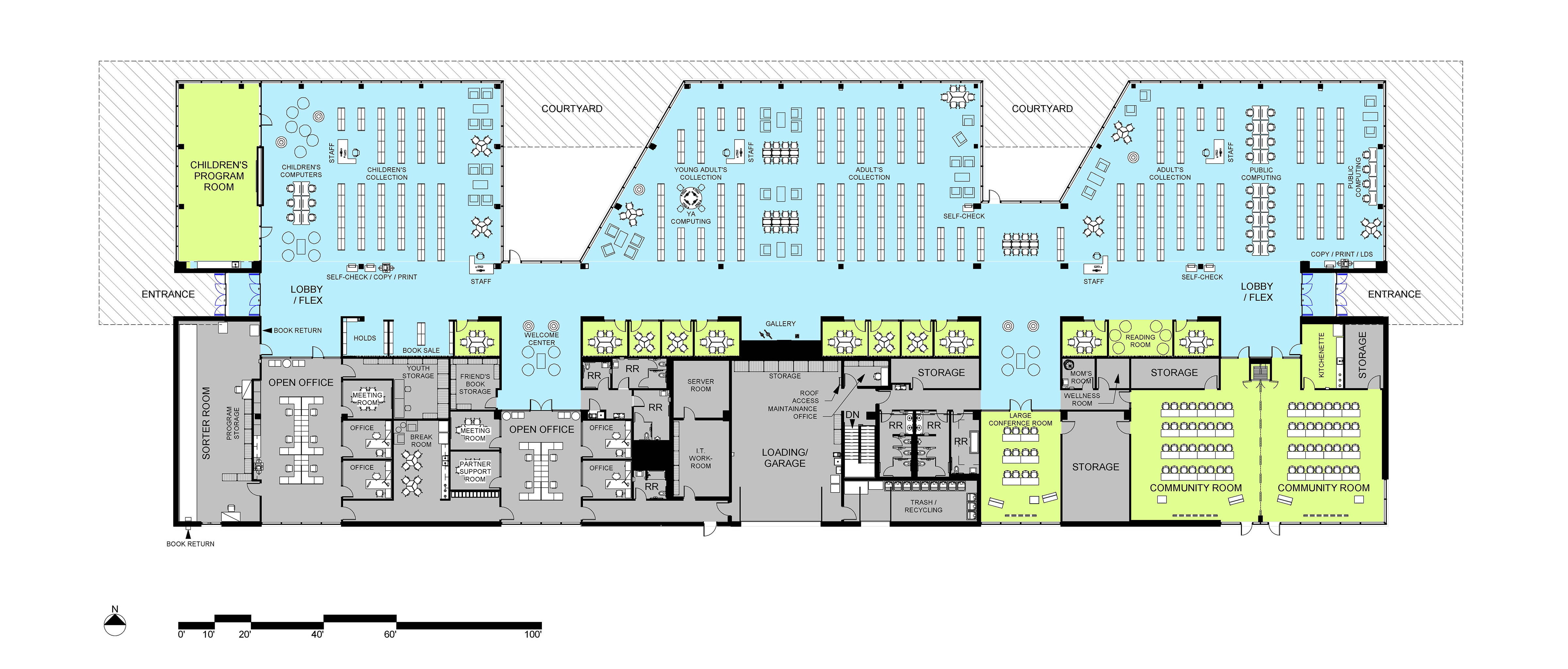
According to the library, the new building will measure about 40,000 square feet, nearly half-again as large as the Ladd space. The increased space will accommodate "larger collection spaces, added community meeting rooms, a larger children's area with dedicated program room, and a new young adult-teen area ("Inspiring Big Dreams" information sheet). They anticipate substantially increasing the current rate of 100,000 visits per year as well.
proposed Westside floor plan
proposed floor plan (from crlibrary.org)

The library will be located towards the southeast corner of the property, near 20th Avenue almost to Edgewood Road. Most of the rest of the land will be developed into a new city park, at least tentatively called Westside Library Park. The park will include a multi-use court, two picnic shelters, a water feature, multiple gardens, and a lot of green space. The western portion, closest to Wiley Boulevard, will be sold. That leaves by my guesstimate about 15 acres for the park, which will be a wonderful resource for the area and environs for the library. Of course, there will be parking, too--one lot off 18th Avenue, and one off a new north-south street at the west end of the park--but not so much as to overwhelm the property.

Westside Library Park site along 18th Avenue SW

There will be quite a few apartment buildings within easy walking distance of the new library. (To find 27 available acres in such a densely populated area is miraculous.) The plans show sidewalks on the developed property on both the 18th Avenue and 20th Avenue sides. To facilitate children independently accessing the library or park, there should be a sidewalk on the north side of 18th Avenue, as well as mid-block crossing lights on both 18th and 20th.
West Park Village mobile home court
West Park Village, across 18th Avenue from the library site

Once away from the immediate vicinity, though, walkability goes quickly to pot. This is an area where the suburban development pattern was aggressively pursued: Edgewood Road, 16th Avenue, Wiley Boulevard, and Williams Boulevard are all wide, high-traffic, high-speed "stroads" that form a ring of danger around the library site. 
Edgewood Road approaching 16th Avenue SW

Residents of the Cedar Terrace Apartments on 12th Avenue, for example, will be only one-third of a mile from the new library, but must make their way across 16th Avenue with its 10,000-15,000 cars per day and 40 mph speed limit. Residents of Cedar Point Townhomes on Westdale Parkway will be 2000 feet away, but must cross both Williams Boulevard and Edgewood Road to get there. Van Buren Elementary School is a mile away, and... you get the idea.

There is talk of connecting the property to the trails system via the Edgewood Trail which will run along Wiley. Bus lines 8, 10 and 12 run close to the site, though none is running more frequently than once every 30 minutes (route 8) this summer, and all are rather circuitous. All of these efforts at accessibility would be made more effective by measures aimed at slowing motor vehicle traffic.

The Westside Library proposal is one of the best ideas around for improving the city. The library provides a vital service, and the new facility will deliver it even better. The proposal is made with careful attention to residents of the immediate neighborhood. The city needs to support the library by doing what it can to make that part of town less dangerous for non-car mobility.

Wednesday, June 12, 2024

Book review: The 15-Minute City


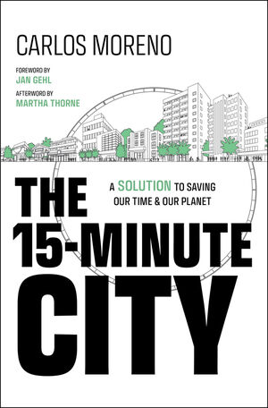
The 15-Minute City cover

Carlos Moreno, The 15-Minute City: A Solution to Saving Our Time and Our Planet (Wiley, 2024), xxii +276pp.

"The 15-minute City" has become a widely popular concept and widely used phrase, especially after it was adopted by Paris mayor Anne Hidalgo to guide that global city's ongoing development. The phrase sprung from the mind of Carlos Moreno, a native of Colombia who is now professor of systems technology at the Sorbonne, when he was attempting to humanize his approach to technology-based city design.

Although I was a pioneer in the emerging field of "smart cities," I saw technology as a powerful lever but no longer as an end in itself. My definitive break with technology-centered approaches came in 2010, when I decided to turn to urban service design as an essential methodology for transforming our cities.... 

[Drawing on the work of Jane Jacobs] My approach has refocused on the design of urban services that meet the needs and aspirations of citizens, putting people at the heart of the debate and integrating fundamental thinking on the geography of time, rhythms, quality of life, and chronotopia--a spatio-temporal concept in which the intersection of place and time creates unique and dynamic experiences in a given environment. [Moreno 2024: 89]

The idea that resulted was that of a city "in which the essential needs of residents are accessible on foot or by bicycle within a short perimeter in high-density areas," or a somewhat larger perimeter in less densely populated areas (p, 14). By reducing the need to commute long distances in cars, the approach is intended to reduce human stress on the natural environment like climate change, but also to reduce the difficulty and time people spend getting places, and to improve individual quality of life and social connection. 

The first third of the book seats the idea in the history of western cities, as a response to the disruptive impacts of cars, Euclidean zoning, and most recently the coronavirus pandemic. These disruptions are familiar to anyone who studies cities, but the story does bear retelling. After 75 years of sprawl we find that "Proximity plays an essential role in lifestyle change and city transformation. The concept of the '15-minute city' and '30-minute territory' is at the heart of this new urban lifestyle..." (p. 13, italics mine). 

It sounds like urbanism! Moreno's multi-faceted approach is indeed similar to that of Jeff Speck, Charles Montgomery, and Jan Gehl (who wrote the forward to The 15-Minute City), as well as not-yet-famous me. Moreno's main contribution is the convenient metric, though at his Congress for the New Urbanism address last month he warned against overfocusing on the number 15.

Carlos Moreno at CNU podium
Carlos Moreno at CNU, May 2024

As we approach mid-book, then, we're set up for a series of examples where the 15-minute city concept has been translated into policy. And we kind of get that. Beginning with Paris (chs 10-11), we go to Milan (ch 12), and then to Detroit (ch 13) and Cleveland (ch 14) in the US, then to Buenos Aires (ch 15), already an admirable array of cities in different situations and parts of the world. The array seems to be the entire story, though, because while we would like to know how cities overcame obstacles to achieve good outcomes (or in the case of Cleveland, which has just begun under Mayor Justin Bibb, what it plans to achieve), we pretty much just get long descriptions of issues and short lists of achievements: Buenos Aires replaced some of its excess of roadways with plantings (Calles Verdes, pp. 186-188); Sousse, Tunisia, adopted a comprehensive plan that included considerations of times and distances travelled, with positive results on a variety of measures (pp. 195-200); Melbourne plans to redevelop a failed mall site (pp. 208-209). Pleszbew, Poland, has built "buffer car parks linked to train and bus services" (p. 221), but I don't know what those are if they're somehow different from regular station parking lots.

When I think of my own town, I think of all the aspects of the problem I wish this book had addressed: How do you assess the problems and potential of your city? How do you overcome inevitable public and interest-group opposition? What are the obstacles to successful formulation and implementation of 15-minute-city-inspired policy? (Speck's book in particular does a much better job of this.) Once the policy is in place, what are some useful measures of success? What are some ways cities have responded to complex or changing facts on the ground? (I think of the presentation on the complicated history of  Barcelona's superblocks I heard this spring.) Some of these are considered in chapters 10 and 11 on Paris, but even then only to a small degree. I'd have preferred four meaningfully detailed cases to a dozen quickies.

At CNU last month, Moreno seemed baffled by the political outrage his viral phrase has inspired. (The first video that came up on an Internet search described 15-minute cities as "the new reservations.") A second edition of this book might address this opposition in a practical way. By "practical" I don't think you're going to convince auto manufacturers and oil companies to be cool, and there's really nothing to be done about the cultural attachment to a car-dependent lifestyle, which is intimately connected to climate denial. But as anyone knows who's engaged even a little with city development, people are more afraid than hopeful about any change that will affect them. Moreno can go on about "happy proximity," but many of us outside of big cities aren't used to any kind of proximity. In Iowa, I'm lucky if someone agrees to share a lap lane at the YMCA pool. One street south of mine, people got everyone to sign a petition against a sidewalk on the south side of the street, including 35 homes on the north side that already had a sidewalk. A new chapter that holds people's hands and assures them everything will not only be okay, but joyously so, and coaches advocates on how to talk to the anxious masses, would be a good addition.

cars lined up at Dunkin' drive-through
Linin' up at Dunkin', November 2021:
How many of these drivers want to live in a 15-minute city?

Thinking about Cedar Rapids also illuminates why Moreno does not want to fixate on a number. There's more, as he would be the first to tell you, to purposeful walking and biking than measuring radii. According to Google maps, a 15-minute walk is about 0.7 miles. I live reasonably close-in, but all that's within that radius is an elementary school, a credit union, two dentists, a grocery store that's closing in a week, several churches, and two fabulous parks (Bever Park and Brucemore National Historic Site). 

Getting on a bicycle means 15 minutes is roughly equivalent to 3.0 miles, which expands my reach to all of downtown, Kingston Village, New Bohemia and Czech Village. Besides all the bars, restaurants, coffee shops, and museums--and hair salons, which New Bohemia has in spades--I am within three miles of the middle school and high school my boys attended, two Hy-Vee Grocery Stores, Bruegger's Bagels, CVS, Walgreen's, two hospitals, Coe College, Mount Mercy University, Cedar Lake (destination attraction in process), and the 16th Street Dairy Queen. When the casino comes, as currently seems inevitable, it will be within three miles as well. But in our town of "happy motoring" (phrase lifted from James Howard Kunstler), not every three mile bike trip is an advisable one. Some of those places require the non-driver to ford huge parking lots, and I won't be riding on Mount Vernon Road any time soon!

wide street with Auto Zone and boarded up shop
Mt. Vernon Road SE, fall 2024: getting in this zone requires a car

So, three cheers for the concept, although I won't be living in a 15-minute city any time, and one and a half cheers for the book.

Monday, June 10, 2024

Riding the Districts 2024

Cyclists and bicycles under cloudy skies
Gathering under cloudy skies at Prairie Park Fishery

This year's Districts ride featured clement weather, two of Cedar Rapids's arguably bikeable destinations, and the latest information on trails development. The ride was hosted by the city's Parks and Recreation Department. The roughly 15-mile ride began and ended at the Prairie Park Fishery, with stops along the route at Indian Creek Nature Center and Bever Park. 

map of the route

Bever Park is along what will become the Interurban Trail from Cedar Rapids to Lisbon. Randy Burke, who has been with Linn County Conservation since 1979, said the trail has been in the works almost that long! There remain land acquisition issues, negotiations of the route with the towns of Bertram and Mt. Vernon, decisions about how to get under the north-south highway (US151/SR13), and "a lot of little things [and] design stuff... it's going to end up being a very expensive project." Ron Griffith, a traffic engineer with the city, said the Cedar Rapids section had federal funding through the Corridor Metropolitan Planning Organization that will allow completion of that portion in 2029.

Interurban Trail map

Posters at the Fishery showed trail development progress across the metro. I was glad to see updates on the CeMar and Grant Wood Trails, although sorry to see their expected completion has been pushed back about six months in both cases, so it will be 2026 before the CR-to-Marion loop will be all finished.

CeMar and Grant Wood Trails final connections

Ron Griffith said the Morgan Creek Trail on the city's west edge has been completed as far as Covington Road, and they are seeking bids on the next phase, which will be followed by fundraising.

Morgan Creek Trail progress

The ride itself was mostly pleasant and occasionally complicated. I counted between 40 and 50 riders. Stephanie Schrader and Doug from the Parks Department got things going--I almost said "rolling"--at the Fishery, a relatively new facility on land donated just a few years ago by the Martin Marietta Corporation which had been the most recent owner of a long-used quarry. It now boasts a 1.7 mile trail loop around the lake, connection to the Sac and Fox Trail, and fishing piers three of which are ADA-accessible. 

speakers address biking throng

They introduced City Council member Ashley Vanorny, who also welcomed the group, and gave a shout out to former mayor Brad Hart who was a fellow rider. Then Ron Griffith talked about the route and trail safety.

Nearly all of the four mile ride to the Indian Creek Nature Center was done on Otis Road, because the trail along the river was partly flooded with all the rain we had in May. We met at the Penningroth Barn, the dairy barn that served as the nature center's headquarters from 1973 until 2016, with which I have many fond associations.

cyclists approach the old barn
arriving at the barn

They still have a few of the old exhibits.

woman speaking, door to the building, pile of bark on a table
Sarah Botkin and a pile of bark

Sarah Botkin, manager of the new headquarters down the road, explained the center's mission as "nature based education and land restoration." She said many other interesting things, too, but I was distracted by the dense squadron of mosquitoes, which embraced all of us like long lost friends. I guess the nature center is lower, wetter, and more wooded than my house!

Penningroth Barn at Indian Creek Nature Center
Penningroth Barn

Most of the five-plus miles to Bever Park were on the Sac and Fox Trail, mostly okay, but occasionally soupy or sandy. A few of us had trouble maintaining balance, but no one was hurt. The crushed limestone surface held up under our tires, too. Eventually the trail will lead directly into Bever Park, but for now we did the same subdivision-plus-brutal-hill that the MPO Ride took in May. I know a better route, at least for individual riders, and next time I am resolved to take it.

At Bever Park, there were snacks...


...and the aforementioned news. And more snacks. Also water of various types.

I rode home from Bever Park. I live right down the street from the park, so I had started my morning by riding the planned final leg from Bever to the Fishery. I did a modified version of their route, via Memorial Drive, McCarthy Road, and Otis Road. None was difficult on a Saturday morning, but I would be leery of cycling that route on a weekday when there is a lot more traffic.

Most riders drove their bikes to the Fishery...

Prairie Park Fishery parking lot
Prairie Park Fishery parking lot is spacious

...which for all its wonderful features is far from a low-traffic street or a transit stop. Same goes for Indian Creek Nature Center. So much of our trail development is car-dependent i.e. it assumes you will drive to the trail. The missing links on the CeMar and other trails can't be fastened too soon!

Wednesday, June 5, 2024

Book review: City Limits


City Limits cover


Megan Kimble, City Limits: Infrastructure, Inequality, and the Future of America's Highways (Crown, 2024)

I can't believe there was a day when people were like, you know what we should do? Tear down all the businesses and houses around our downtown. That seems smart. Let's do that.
--BETH OSBORNE, Transportation for America (Kimble 2024: 202)

This is an even better book than I expected. At its heart it is the story of grass-roots movements in three Texas cities--Austin, Dallas, and Houston--in opposition to Texas Department of Transportation plans to widen interstate highways through the centers of their towns. Those stories are well-told, including accounts of public hearings and interviews with participants on all sides. Results of their efforts were mixed, but demonstrated the importance of community input.

Megan Kimble
Megan Kimble (from her website)

Besides that, City Limits has two features that make it valuable to those of us who don't live in Texas. (Remarkably, I have not been to any of the three cities!) The first is to describe early in Part I the context in which the current controversies exist, that being the story of the Interstate Highway System. President Dwight D. Eisenhower famously championed that system, but explicitly as an inter-city road network. Apparently without his knowledge, the program aggressively included highways built through cities as well, including all three of the Texas cities discussed (see pp. 27-34). 

The intra-city highways typically obliterated many blocks of existing black neighborhoods and lowered the quality of what remained. This experience was seen with I-90/94 in Chicago, I-94 in Minneapolis-St. Paul, and probably your town as well. 

old pictures of houses and stores
"Before" picture from Dan Ryan Expressway hologram
(my photo at National Museum of American History)

(In Cedar Rapids, without a substantial black population, I-380 plowed through a working-class white neighborhood, and its huge right of way remains an obstacle to development on the west side of the river.) She also discusses highway removals in San Francisco and Rochester, with possibly more to come.

The second feature of the book that is relevant to readers in and out of Texas is hearing directly from those affected by intracity highway construction and expansion; these conversations make up much of Part II. We meet Lockridge Wilson, whose Dallas neighborhood was cleaved by I-45, which he now uses to get to work; Elizabeth Wattley, who managed restoration of Dallas's historic Forest Theater before she found it in the path of I-45 expansion; Elda and Jesus Reyes of Houston, who rally their mostly Spanish-speaking neighborhood to defend their homes against I-45 expansion; Angel and Michael Leverett, who live in the Austin suburb of Kyle, reliant on I-35 while choosing employment that will somewhat minimize their commutes; and dozens more. Their stories add dimension to the policy problem, and though neither you nor I are likely to meet any of these people, there are stories just like theirs in the places where we live.
street facing grass berm leading up to highway
Berm view: 3rd St SW, looking up at I-380

Kimble concludes the book on a hopeful note, but there really are no clear signs of what the future will bring for intracity highways. We need to stop doing what we've gotten used to doing, as well as undoing some of the damage where we can. Their social and environmental costs are hard to ignore, and their financial costs are prodigious, though maybe not as visible as other areas of government budgets. ("I don't think federal taxpayers should be subsidizing the costs of [mass-transit] systems," Baruch Feigenbaum of the Reason Foundation tells a congressional hearing (p. 99), conveniently overlooking that highway infrastructure too is "subsidized.") Land costs, too: outside of the city, but the junction of Interstates 80 and 380 was recently redone to correct a serious problem with the original design, and the footprint of the new interchange is at least as large as the entire downtown area of Cedar Rapids including Kingston Village. (I have it 1.35 square km for the interchange... 


...1.3 square km for downtown-plus-Kingston including the river.)


However, the obstacles to change are huge. It seems expressways are one policy where powerful economic interests are at one with the cultural interests of the Republican party base. This is particularly true in Texas, where private motor vehicles are as sacred as teaching Christianity in public schools, opposition to abortion, closing the border, and free access to heavy weapons (see page 12 of the Texas Republicans' new party platform; for perspective on that platform, see Tumulty 2024.) Neither Texas Governor Greg Abbott nor Transportation chair J. Bruce Bugg have a background in transportation, but they know what they like, and it involves adding lanes (p. 9).  Heck, even in New York, there are limits to how much the interests of local residents can match up with those of commuters.

pictures of highway protests from 1960s
1960s highway protests in Washington, ultimately successful
(my photo at Anacostia Museum)

A recent Supreme Court ruling penned by Justice Samuel Alito (cf. Howe 2024), though it dealt with congressional districting, raises a lot of doubts about whether disparate racial impacts can stop highway expansion as they were in Houston, without an explicit statement from planners that the highway was intended to harm blacks. The costs we've sunk into building expressways also inhibit change: in the long run, public transit is more scalable and less harmful, but at present adding highway capacity is easier.

We've been making a mess of things for 75 years, and now we've built our cities and our lives around coping with it. The way forward is far from simple or clear, but Megan Kimble has given us a good introduction to the issues involved.

SEE ALSO: Dan Allison, "Lawsuits Against YOLO 80," Getting Around Sacramento, 4 June 2024
Joe Cortright, Driven Apart: How Sprawl is Lengthening Our Commutes and Why Misleading Mobility Measures are Making Things Worse (City Observatory, 2010)
Freeways Without Futures 2023 (Congress for the New Urbanism)

Monday, June 3, 2024

10th Anniversary Post: West Side Greenway


trees, lawn, sidewalks
Time Check post-flood, June 2014

Ten years ago this month, the City of Cedar Rapids had an open house at the Flamingo Events Center on the near northwest side to discuss plans for a greenway along the river where some of the worst flood damage had occurred in 2008. The greenway would stretch from Ellis Park, one of the largest and oldest parks in the city, to Czech Village, about four miles in length. Some of the ideas that were floated at the time included basketball courts, one or two boat launches, disc golf putting green, an ice rink, and a ropes course, as well as improvements to the riverside bike trail. At the time I concluded: The special elements... will serve as "demand goods" [term I cribbed from Jane Jacobs], drawing people from all parts of the city and beyond. But the ongoing success of these projects depend on the ability of planners to coordinate effectively with neighborhood and commercial development.

2024: distant view of Ellis Flats, 1618 Ellis Blvd NW
across field planned for trail, water play, skate/skills park

Federal support for west side flood protection was not approved until 2018, and only last week did the City Council approve the final version of the greenway plan. The next step is fundraising from the federal government and other sources (Payne 2024). The plan is divided into short-term (next five years) and medium-term (next ten years) phases. 

The future impact section of the plan anticipates 1-2 million annual visitors to the parks, with the middle estimates projecting $250-500 million in new investment, $60 million a year in economic benefit, and creation of 1300 jobs (p. 86). (These numbers should be taken with a grain or perhaps a pillar of salt. Does anyone ever go back and check these numbers later?) 

grassy area with flood wall and elevated highway
1st St and 1st Av NW: plans for whitewater rafting course

parallel sidewalks between street and river
1st St and E Ave NW: plans for trail improvements,
Fallen Forest nature play area

Plans for the middle section ("Riverfront Park," discussed on pp. 59ff. of the plan) do not discuss its interface with the latest casino proposal. (See "Cedar Rapids Casino" 2022.) That may be prudent, because approval of the casino at the state level is by no means certain, but it's worth noting the current 1st Street NW will be rerouted and converted into a park road, and that the footprint of the park, particularly near the proposed nature play area and dog run, intrudes upon the footprint of the casino. This is fine with me, since I wish the casino would go far away, but if two would-be tourist destinations are to exist cheek-by-jowl in what used to be a residential neighborhood, it will require some thinking.

intersection, plastic fencing, grassy area
1st St and F Ave NW: dog run, parking for whitewater rafting... and casino?

wide street with cars, buildings in background
1st Ave at 1st St W: still a wide, high speed highway
through the center of town 

The chain of park areas provides a number of potential benefits to nearby neighborhoods; it will be interesting to see how these considerations are balanced with the expectation of being a tourist magnet. The Time-Check Park is adjacent to development along Ellis Boulevard NW as well as existing residential areas to the west. Ellis could be a challenge for small children to cross, but overall the park should be easily accessible on foot to a lot of people. 

house with anti-development signs
Not this neighbor, though: 1426 1st St NW (and others?)
stand in the way of the canoe safari and picnic grove

Ditto the gardens, water play area, toddler area, and roundhouse in the Czech Village Park on the southwest side. Its area also has planned residential redevelopment, existing residences, and a challenging through street (C Street SW, in this case). I hope there will be some routine play equipment for the littles, but the bigs ought to find more places to explore than in a typical city park. 

grassy area with houses in distance
approximate site of B St SW woonerf
plans for toddler park, water play, playground

Accessible green spaces that are somewhat wild provide benefits to individuals as well as the overall ecology (Galle 2023). This all adds to the attractiveness of the neighborhoods. In a best-case scenario, the neighborhoods would provide steady use of the parks, with folks from farther out adding their own energy without overwhelming things, and the city will be committed to ongoing maintenance and improvement.

The big question remains from 2014: Will the Greenway project be able to evolve along with the neighborhood, while accommodating visitors from elsewhere, like our city's flagship parks? Or will it be primarily a "destination," separated and alienated from the place where it's located, like the baseball stadium, New Bo City Market, and the proposed casino (though any of these may change in time)?

MAIN SOURCES

Marissa Payne, "Cedar Rapids Will Seek Funding to Bring Greenway Plan to Life," Cedar Rapids Gazette, 29 May 2024, 1A, 8A

Greenway Parks Plan Update (City of Cedar Rapids)

High hopes for new Westside library

  Proposed Westside Library (from crlibrary.org) The Cedar Rapids Public Library plans to open a new west side location in late 2026, on 27 ...