 |
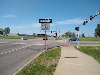
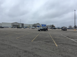
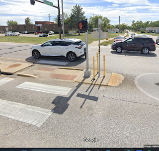
Crossing Collins Road NE at C Avenue, looking north:
45mph six lanes, plus turning traffic off C |
Harvard University's Journalist's Resource has a backgrounder this week (cited below) on crosswalks, which got me to wondering: What are Cedar Rapids's most dangerous intersections for pedestrians, and what are we doing about them?
The studies aggregated by Journalist's Resource identify characteristics of street crossings with the most pedestrian deaths and injuries:
- near commercial zones
- speed limits over 30 mph
- heavy foot and vehicle traffic (vehicle counts 25,000+ per day)
- long crossing distances
- right-on-red turns allowed
- no or simple crosswalks (without stop signs or lights)
- areas with higher percentages of people with physical disabilities and/or racial and ethnic minorities
Sounds a lot like
stroads! (See the extensive critique of this type of road design in Charles L. Marohn Jr's
Confessions of a Recovering Engineer: Transportation for a Strong Town [Wiley, 2021], which I reviewed
here.)
 |
| Edgewood Road at 29th Avenue SW, 2016 |
Below are the busiest streets in Linn County, as measured by the
Iowa Department of Transportation 2021 traffic counts. (
Where 2021 counts were not done, I used 2017 counts. Where comparable 2021 counts were lower than in 2017, so maybe mentally discount the '17 numbers a bit. I exclude I-380 and US 30, which are limited access highways.)
Collins Road (Route 100): 30300/32000 at Council Street NE, 23900/24500 at C Avenue NE, 22800/24800 at Lindale Drive NE
C Avenue: 25800 at Blairs Ferry Road NE, 23000 at Boyson Road NE [surface trail crossing north of Blairs Ferry]
Edgewood Road: 24200/24300 near Collins Road NE, 21000 north of Ellis Boulevard NW, 24700 north of O Avenue NW, 21500 north of 16th Avenue SW, 20800 at US 30 SW
1st Avenue: 20900 at 15th Street W, 22300/19700 at 5th Street W, 20700/19200 at 10th Street E, 21000/21100 at College Drive NE/13th Street SE, 20400/20900 at 35th Street E, 20100/23100 at Collins Road NE [surface trail crossing at 4th Street E, trail underpass near 30th Street E]
Marion Boulevard: 28300 at 1st Street (Marion) [trail underpass near 1st]
Route 13: 22000/17400 at 10th Avenue (Marion) [trail underpass half mile south of 10th]
My advice to pedestrians at most of these streets would be not to walk there at all. My advice to planners is to spend their time on other areas that have greater potential for walkability--you can do more for your crosswalk dollar making a good area great instead of making a badly-designed area less bad. Back in 2015, I made just that case
with regard to proposed Collins Road improvements.
That advice is as cheap as it sounds, and I've had time since 2015 for second thoughts. My impeccable logic neglects the fact that people are living at these locations, and some are likely to have to/choose to walk. Here is a Google map of the area around C and Boyson that I've swiped from
a piece Ben Kaplan wrote in 2016. I have not asked him for permission to use it, but I will, probably soon.
 |
(Traffic counts: C Avenue has 14400 north of the intersection,
23000 south; Boyson has 15100 east, 14200 west) |
Note the proximity of many residences to the shops, but that the design of the area makes it unpleasant, difficult and dangerous to get from one to the other outside of a motor vehicle.
Many if not most people living near extremely busy streets are the very sorts of people who are overrepresented in pedestrian casualty statistics. Take, for one instance, the intersection of 10th Avenue and Routes 13/151 at the edge of Marion. (
I spent Black Friday there in 2019!) 10th Avenue runs east-west, with 13000-16700 vehicles per day (measurements were taken on either side of Route 13); Route 13 runs north-south, with 17400-22000. The speed limit is 50 mph in all directions except 10th Avenue going towards town where it's 45 mph. They are four-lane divided highways, with a Wal-Mart Supercenter, fast food restaurants, and convenience stores at all four corners. Absolutely nothing about this intersection says "walk here."
 |
US 151, approaching State Route 13 from the east
(Google Earth screenshot) |
And yet, I'm pretty sure some people absolutely must. Near the northwest edge of this intersection is a prefab housing development, Eagle Ridge, and near the northeast edge is another, Squaw Creek Village. North of that are a series of apartment complexes. Wal-Mart is less than a mile away, and yet getting there without a car is unpleasant at best and probably life-endangering.
 |
| After you cross the intersection, there's the parking lot to navigate |
At 13 and 151, there are no crosswalks or even sidewalks, turn lanes in every direction, and it must be close to 100 feet across. (So it would take the average person about 30 seconds to traverse.) There is a trail crossing under Route 13, but it's half a mile south of 10th Avenue, so even if you were willing to walk that far out of your way and back, you'd still have to cross 10th to get there.
Another case in point is the area around the former Westdale Mall. (I spend Black Fridays there in
2016 and
2022.) Census tracts 10.04 and 10.05 on the southwest side are bounded by Edgewood Road, Wilson Avenue, West Post Road, and Midway Avenue. These tracts are among the poorest in the metro, particularly tract 10.04--west of Wiley Boulevard--with a 2021 median family income of $29,707, about half the amount for the city as a whole (
data.census.gov). In the 2010 census, when 10.04 and 10.05 were a single tract (10.03), it was among the
highest in the county in housing density, percent black, and percent Hispanic. What's also notable here is the concentration of four-lane streets: Edgewood, Wilson, Wiley, 16th Avenue, Johnson Avenue, and Williams Boulevard define the area. To walk to school, a park, the new public library facility, or the Fareway Grocery requires crossing at least one of these stroads. Only Edgewood is over 20,000 cars per day in the 2021 counts, but that's a mixed blessing; four-lane streets like Wiley with less traffic tend to see faster car speeds which are more likely to lead to deadly impacts.
What's the answer here? Tunnels? Expecting or even requiring residents to drive everywhere? Forbidding residential development in such a hostile environment? The studies cited by the Harvard report commend:
- longer "walk" times (don't assume a 3.5 foot per second walking speed)
- medians for middle-of-the-street refuges
 |
median, C Street crossing Collins Road
(Google Earth screenshot) |
- lighting treatments, including overhead lights, in-road flashing lights, and lighted bollards
- crossing flags [I've seen these in Madison, Wisconsin, but not around here]
- "gateway" reflective signs
- street trees
 |
plantings along Collins Road probably don't slow traffic
as much as the lack of friction encourages speed
(Google Earth screenshot) |
- law enforcement cameras
- T-intersections (probably too late for existing intersections, and they do guarantee all of the traffic on your street will be turning)
If I were in charge of rectifying these intersections, I'd be afraid even to paint a crosswalk lest it encourage more people to walk there, but afraid not to leave it in such a hostile condition because some people will have no choice.
[NOTE: 1st Avenue in Cedar Rapids presents a special set of challenges, so it gets its own post next week.]
SOURCE:
Clark Merrefield, "Crosswalks and Pedestrian Safety: What You Need to Know from Recent Research," Journalist's Resource, 10 July 2023
SEE ALSO:
Marin Cogan, "Why Pedestrian Deaths in the US Are at a 40 Year High," Vox, 6 July 2023 [Because (1) deadly road design viz. 60.4% of deaths on stroads, (2) bigger and bigger vehicles, (3) possible additional reasons including (a) faster driving habits from the pandemic shutdowns, (b) fraying social fabric and/or (c) lack of traffic enforcement]
Ben Kaplan, "Mount Vernon Road is Dangerous By Design," Corridor Urbanism, 11 June 2021 [18300-18800 vehicles per day at 15th Street SE, and likely to get more and faster with the redo]


No comments:
Post a Comment