 |
| F Avenue and 15th Street NW: Last stop, hearing about plans for the Cherokee Trail |
An impressively large turnout of bicyclists rode about 10 miles around the west side of Cedar Rapids on a impressively lovely Saturday, and heard from city and county officials about plans to complete the trails network around the metro. The group covered all age groups and a variety of abilities, but we managed to stay more or less together.
 |
| Starting at Ellis Park, welcome message from Mayor Tiffany O'Donnell |
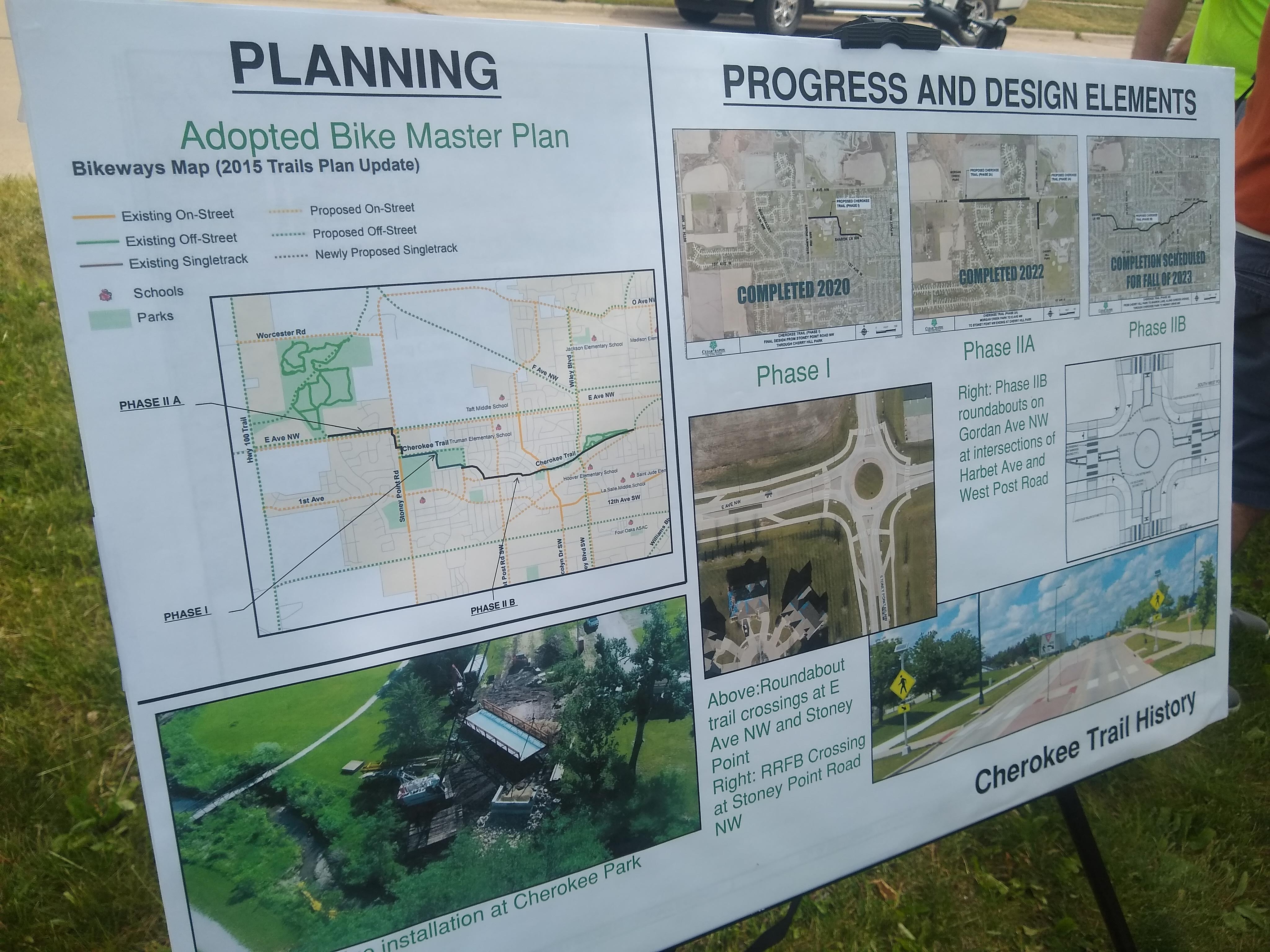 |
| Cherokee Trail plans |
Our first stop was across Wiley Boulevard NW, across from the entrance to Cherokee Park, which now has a new improved bridge across the ditch.
 |
| West entrance to Cherokee Park |
The Cherokee Trail, when completed, will run east and west between downtown Cedar Rapids and Morgan Creek County Park at the very west edge of town. This will be an important commuter route as well as a recreational trail.
 |
| maps showing next phase of Cherokee Trail Development, going east from current trail |
Completion date is uncertain, though: as we heard at our third and final stop, the final section nearest downtown is still waiting on decisions about land acquisition, routing, and coordination with flood control. Right now it goes only to the east end of Cherokee Park, with the section across Edgewood Road to 13th Street in the works for 2025.
We trailed it out to Morgan Creek County Park, with some tricky interactions with car traffic due to the size of our group. I think solo riders and smaller groups will find the route less complicated, although at the trail crosses the vehicle entrance to the park, so one as always is advised to be careful.
When these trails are completed, they will add to a burgeoning network of functional, safe in-town trails. I was encouraged by reports during my recent trip to Charlotte that the network there has done wonders for bicycle commuting (and that city's core is much less prepared for cycle traffic than ours is). Now we need to figure out how to promote commuting.
 |
| Gordon Ave NW as well as Sharon Lane will be dubbed bicycle boulevards |
We trailed it out to Morgan Creek County Park, with some tricky interactions with car traffic due to the size of our group. I think solo riders and smaller groups will find the route less complicated, although at the trail crosses the vehicle entrance to the park, so one as always is advised to be careful.
At Morgan Creek, there were snacks in the new shelter, and we got a pile of trail updates from Randy Burke, Outdoor Recreation Planner for Linn County:
 |
| Randy Burke and visual aids |
In particular, the Morgan Creek Trail will go north out of the park and then swing east to meet the Cedar River Trail (so, from 9:00 to 12:00 on the clock face). Construction is ongoing, with completion date uncertain. The last piece will be the bridge across the Cedar River:
 |
A couple other lingering questions:
- How much redundancy does a functional trails system need? Predictions of misery following this weekend's bridge collapse on I-95 reminds us that systems that are vulnerable to failure at any point are not resilient. The grid pattern of streets is resilient--if a sinkhole appears on 2nd Avenue, we can go down 1st Avenue or 3rd Avenue--while suburban arterials are not. Are trails built to accommodate failure?
- Speaking of which, do we have the budget to maintain all the trails we're building? Riding to Ellis Park Saturday along the west side of the river, I can attest that older bike path is quite rickety. New trails get old. Will we be ready when they do?
SEE ALSO: Nadine Brock, "April 2023 Trails Update," Linn County Trails Association
 |
| Your humble blogger with fellow St. Paul's United Methodist Church members during Morgan Creek Park shelter stop (Photo by helpful stranger) |


No comments:
Post a Comment