 |
| 1903 storefront at 73 16th Avenue SW |
"What are your five favorite streets in your town?" asked someone on Mastodon the other day. Unfortunately, I can't remember who inspired this post, but it does allow me to promote my presence on the oddness that is Mastodon: You'll find me at @brucefnesmith@mastodon.coffee. There are lots of urbanists on Mastodon!
I mulled, cogitated, and in time came up with five streets in Cedar Rapids that I love. I'm going on pure visceral reaction here, though I will try to explain my love for each, which seems based in a stew of walkability and nostalgia. The streets are listed alphabetically; they are too different for me to attempt to rank them. I add the caveat that I've lived and worked my entire Cedar Rapids life on the east side, so I just don't know the west side as well. It gets some love, too, however!
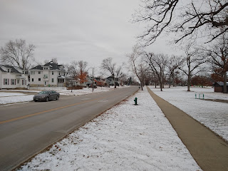
Bever Avenue SE (2400-3000).
A lovely urban boulevard that lost quite a bit of its tree canopy in the 2020 derecho, but still retains its aesthetic charm. Pedestrians gravitate to it because many of the residential streets to its south lack sidewalks. On the north side is Bever Park, one of the town's largest and oldest parks which includes two playgrounds, a duck pond, swimming pool, picnic shelter and wooded trails. Average daily traffic count: 4980. Served by the #2 bus below Memorial Drive.
Yes, but: Despite the thoughtfully stenciled sharrow, auto traffic moves too fast for comfortable cycling, and the lack of stops requires cautious crossing from the residential area to the park. Besides the park, there are few attractions within an easy walking distance.
 |
| Bever Avenue, looking west from park entrance |
4th Avenue SE (1900-2100).
Old-fashioned houses are charming if on the large side. This is one of my favorite streets to walk at Christmastime. The poet Paul Engle (1908-1991) had a childhood paper route here, and in his memoir described the tree-lined street, trees that spread up and outward, meeting high above the middle of the street, so that walking along them in summer was going through a green tunnel. Those houses at a distance looked calm, quiet, outside the turbulent world. But to a boy of twelve they were crammed with excitement, with living, tense, often wild faces. Windows were the way I looked into their eyes (A Lucky American Childhood [University of Iowa Press, 1996], p. 62). The #2 bus runs close by.
Yes, but: Like 8th Avenue in Marion, which is another street I love, the lovely houses are going to be too big for most of us. It's a strenuous though doable walk to downtown or any other attractions.
 |
| 4th Avenue, looking east from 20th Street |
Johnson Avenue NW (200-300).
Shady older street with a mix of houses, within walking distance of a supermarket, schools, churches and some small offices. At one end is Haskell Park, a pocket park named for the state legislator who championed the Lincoln Highway. Farther down Johnson is a Dairy Queen. Across 1st Avenue, alas a crossing not to be taken lightly, are Cleveland Park and the baseball and football stadia. Downtown is about a mile and a half away. Served by bus routes #8 and #10.
Yes, but: As a segment of the original Lincoln Highway, it connects two high-traffic stroads.
 |
| Johnson Ave NW (Google maps screen capture) |
Longwood Drive NE.
Longwood and its sister streets, Dunreath and Gwendolyn, were shoehorned between 19th and 20th Streets some time in the 1920s or 30s. We lived on Longwood from 1997-2007, and I loved the closeness of the small lots. On the edge of the Mound View neighborhood, there is a pocket park (Tomahawk) at the end of the street, and beyond it the CeMar Trail and the athletic fields of Mount Mercy University. Franklin Middle School, the Tic Toc restaurant, and the Old Neighborhood Pub are within easy walks, and Coe College isn't terribly far, as I can personally attest. The street has neither curbs nor gutters, but slopes toward the middle, which during rainstorms creates a creek known as Big Al. The #3 bus runs close by.
Yes, but: There are no sidewalks. The closest elementary school closed years ago, and the second-closest is shortly going to be closed, too.
 |
| Longwood Drive, looking north from C Avenue (Google Maps screen capture) |
16th Avenue SW (000-120).
This was the main commercial street in pre-flood Czech Village, though bars and knick-knacks have replaced essential services to the neighborhood that is no longer. Thanks to visionary property owners like Mary Kay McGrath and Bob Schaeffer, Czech Village has managed to retain much of its historic charm through this transitionary period.The narrow street makes walking easy, and it contains probably my favorite bar (Lion Bridge, at 59) and coffee house (Cafe St. Pio, at 99). If I were a plant person, my favorite plant store would be Moss, at 74. The Cedar Valley Nature Trail crosses 16th Avenue at A Street. Average daily traffic count: 4720. The #7 bus stops at 16th and C.
Yes, but: There are few residences nearby now, though plans for development of the flooded area to the south are in the works.
 |
| 16th Avenue looking southish from A Street. Lion Bridge's courtyard is on the left. |
SEE ALSO:
"The Urbanest Places in Cedar Rapids?" 16 July 2020
"The Place Where I Live," 1 April 2013
Cedar Rapids bus routes: https://www.cedar-rapids.org/residents/city_buses/routes.php
Cedar Rapids average daily traffic counts: https://iowadot.gov/maps/msp/traffic/2021/cities/CedarRapids.pdf
Linn County trail map: https://linncountytrails.org/trails/


No comments:
Post a Comment