
Cedar Rapids celebrated the 10th anniversary of our cataclysmic flood by showing off the progress of the flood control system as well as the remarkable rebirth of flooded areas. Observances included the dedication of memorials in the Time-Check neighborhood...
 |
| north side of O Av |
 |
| south side of O Av; clocks are set to 10:15 when the river crested |
...an organizational fair at the Veterans Building...

...a tour of restored historic properties...
 |
| The Kurik House (1910s) was moved from 1024 to 1028 2nd St SE |
 |
| The exterior and interior were painstakingly restored by Todd Sabin; today it houses Baby Time and an upstairs apartment |
The flood control system, funded with a mix of federal, state, local and private contributions, combines a variety of elements: earthen levees, concrete walls, movable walls and pump stations, as well as one detention basin in New Bohemia.
 |
| The slab is for receiving snow from plows |
 |
| Section of wall seen from across 16th Av at 2nd St |
 |
| Construction underway near Bowling and C Sts |
 |
| Sign at McGrath Amphitheatre marking 2008 water level |
The city estimates the total project costs as $550 million up front, $750 million over 20 years, of which about half has been secured: "City leaders continue to develop ideas to determine a funding source for the City's commitment ($110 million) as well as additional funding gaps necessary to construct the entire system." Linn County voters defeated local option sales tax referenda in 2011 and 2012.
Ten years has seen a lot of investment in the flooded areas, both commercial and residential. Assistant City Manager Sandi Fowler cited 364 new units--mostly apartments and condominiums--in Kingston, across the river from downtown, 113 of which are designated "affordable." This represents an investment of $90 million.
 |
| New condominiums on the west side |
The National Czech and Slovak Museum and Library is on higher ground, having been moved from its riverfront location in 2011. Mercy Medical Center, one of the city's two hospitals, was affected but figured out solutions for its patients as well as putting itself back together. The city has also seen construction of a new public library, fire station, city market, juvenile detention center and (currently under construction) county public health building. Historic features like the Paramount Theater, Gatto Building, and Roosevelt Hotel were saved and restored, as were smaller buildings like this former sausage shop and adjacent beer warehouse:
 |
| Shops in the 1100 block of 2nd St |

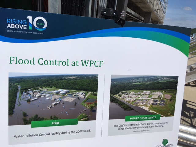
The 1980 Water Pollution Control Facility southeast of the city had to close for two weeks in 2008, and was not fully operational again until September. In 2014 it was augmented with flood walls and berms as well as re-designed components.

The anniversary was not without its bittersweet moments, as despite the subsequent progress, the flood did bring considerable stress to home and business owners, and several blocks of housing near the river have been turned into green space...
 |
| Looking east from Northwest Neigborhood memorial |
Local historian Mark Stoffer-Hunter took time on his historic preservation bus tour to note commercial buildings that were lost, either due to the flood itself or--as in the cases of the Smulekoff's Building and Cooper's Mill Hotel--to make way for flood protection. I was pleased to see that the Northwest Neighborhood memorial included a map showing where there had been housing since the flood.

Taylor School, restored after the flood and reopened in 2009, is slated for closing in the next few years as part of the school district's consolidation plan.
It is also clear, from census tract analysis, that the benefits of rebuilding have not reached everyone. Of the six flood-affected tracts in Cedar Rapids where data are comparable across decades, there has not only been the population loss you would expect but in some areas definite increases in poverty.
CENSUS
TRACT
|
APPROX.
AREA
|
POP 2000
|
POP 2010
|
POP 2016
|
POV 1999
|
POV 2012
|
POV 2016
|
12
|
West side:
TimeCheck
|
3215
|
1282
|
1684
|
8.7
|
17.9
|
14.1
|
22
|
West side:
Kingston
|
2941
|
1832
|
2185
|
11.6
|
29.3
|
26.3
|
26
|
West side: Czech Villg
|
2967
|
2416
|
2745
|
15.4
|
17.4
|
19.9
|
19
|
East side:
Downtown
& MedQtr
|
3359
|
2891
|
2921
|
22.5
|
37.5
|
38.8
|
27
|
East side: New Boh & OakhillJ
|
1842
|
1549
|
1666
|
28.2
|
36.8
|
41.3
|
28
|
East side: so of Mt Vernon Rd
|
4223
|
4126
|
4247
|
6.9
|
9.7
|
8.5
|
[Sources: American Community Survey, Brookings Institution]
In three cases (19, 22 and 27) the poverty increases have qualified those areas for Opportunity Zone designation by the federal government, which may stimulate further investment. It remains to be seen how widely the benefits from that investment will flow.
Cedar Rapids faces challenges, both of sustaining its post-flood resurgence and of making the benefits of its prosperity more inclusive.
Special thanks to Rob Davis, Sandi Fowler, Roy Heseman, Mike Kuntz and historian extraordinaire Mark Stoffer-Hunter for leading bus tours on June 18, 2018. Much of this information comes from their narration and handouts.
EARLIER POSTS:
"Proposed Cedar Rapids Greenway," 13 June 2014
"CR Flood '5 Years Out,'" 31 May 2013
 |
| Special Gazette page 6/10/2018 |


No comments:
Post a Comment