They were there for the deals at the Marion Wal-Mart
Even frigid temperatures could not deter this devotee of #BlackFridayParking, Strong Towns' annual photographic survey of excess parking. Cultural devotion to ensuring drivers have an easy (and free or cheap) time storing the cars wherever they go has created a profligate use of land. Case in point: I went to a bar with some coworkers the day before Thanksgiving. It's a small building, 1800 square feet. Do you know how many parking spaces would fit in that building? Ten. That's all. So you can just imagine how many alternative uses we're foregoing with just one single megaparking lot.
Northwest section of the lot, 9 a.m.
This year's observance of #blackfridayparking took me to the Wal-Mart at the edge of Marion, or what used to be the edge of Marion, at the intersection of US151 and SR13. Built in 2005, it is the most newest of our metro's three Super Centers. There were a lot of people shopping there, and a lot of cars parked, and yet, as busy as it was, huge swaths of the lot went unoccupied. I'd guesstimate it might have been 55 percent full.
View from McDonald's
Northeast edge
Marion has grown quickly, more than doubling its population since 1990. More recently they have reconfigured traffic to enhance their Uptown area, and are engaged in writing a comprehensive plan for the next 25 years. For thirty years, though, their growth was an explosion of suburban development, much of it along Business Route 151, which runs from this intersection through the center of town into Cedar Rapids, where it becomes 1st Avenue East. So for about two miles, it seems like the edge of town, because the edge has moved ever-outward as the town has grown.
Hy-Vee Grocery Store, 3600 10th Avenue. Maybe 75 percent full at 9:30 a.m.
Average daily traffic counts along this stretch are 16700 across 151/13, 13000 above 50th St, 11700 between 50th and 44th, and 14400 between 44th and 35th; after a roundabout routes traffic onto 6th Avenue, 7th Avenue still carries 5600 approaching 26th Street.
Auto-Zone, 1055 Linden Drive. Last picture I took before my camera rebelled.
I walked along BR 151 to a coffee appointment in Uptown. It really gives you a sense of how human scale is lost in auto-centric development, in that I could walk five minutes and feel as though I was getting nowhere. It's difficult to convey in photographs, particularly since my phone rebelled against the cold at this point--it was about 15 degrees, and windy--and refused to come out of its shell until we were safely inside the coffee shop.
Best I could do: Google Earth screenshot looking east from 31st Street
As Marion undertakes its new comprehensive plan, they may or may not try to diversify this route. There certainly is a lot of parking along the way...
Screenshot from Marion 2045 page, showing 26th to 44th Streets
Screenshot from Marion 2045 page, showing area around Wal-Mart and 151/13 intersection
...which arguably is a bigger issue than whatever's going on at Wal-Mart.
Spending land that could be productive and interesting on parking lots seems irrational to me. But so does waiting ten cars deep at a drive through, and I saw that at both Starbucks and Dunkin today. So do all the people huddled under blankets in the long line outside Da Bin consignment store. There is clearly much I don't understand, which keeps your humble blogger extra-humble.
2317: One of many smokeshops on the road, used to be a bookstore
I've gone a bit off-script for this year's celebration of #BlackFridayParking. Strong Towns has promoted this event since the mid-10s as a way of highlighting the high costs to cities of zoning regulations that mandate large commercial parking lots (Abramson 2023). Past Black Fridays have taken me to the parking lots of big-box stores on our city's outer edge, and to the vast parking lots all too close to our city center.
Amidst all the giddiness and photography, I've come to the conclusion that, in Cedar Rapids anyway, the problem is not the zoning code. Our giant Wal-Marts and Targets have parking lots even bigger than the code requires, because land is cheap here, customers expect it, and the city is designed in such a way that 90+ of people are going to drive to shop anyway.
Still empty in '23: former K-Mart parking lot, 16th Av SW, November 2017
The problem on 16th is not that even large Black Friday crowds couldn't fill the gigantic parking lots, but that there are no crowds at all. (That year I was accompanied by "the other Dr. Nesmith." I don't know whether the excitement was too much for her, but she hasn't been tempted by #BlackFridayParking since.)
This year I followed a similar impulse to Mt. Vernon Road SE. This historic corridor is getting some love from the city in the form on an action plan. Alas, its internal contradictions mean some of its goals are going to have to give way, probably to faster vehicle traffic.
The Mount Vernon Road action plan covers 10th to 44th Streets.
4035: At the east end of the plan area, acres of parking at the Mt. Vernon Road Hy-Vee
The executive summary describes the challenge on page 19:
The Mt. Vernon Road corridor includes a wide variety of land uses including a neighborhood hardware store, a large grocery store, several gas/convenience stores, banks and credit unions, professional offices, restaurants, bars, and various specialty, variety, drug, auto parts, auto repair, and discount goods stores. The corridor also includes schools, churches, a residential care center, a fire station, and a cemetery.
2405: Used to be a pharmacy
However, the dominate [sic] land use is single family residential with just a few multi-family residential properties sprinkled throughout the corridor. There are several quick-serve and fast food restaurants but few sit-down style restaurants. There are vacant properties along the corridor and some occupied commercial sites that are dated and/or in need of renovation and maintenance. There are also several retail uses that are typically not considered neighborhood friendly including tobacco shops and liquor stores.
Because that's the kind of commerce wide fast streets get!
2663: Used to be a Greek restaurant
2700: Used to be an Italian restaurant
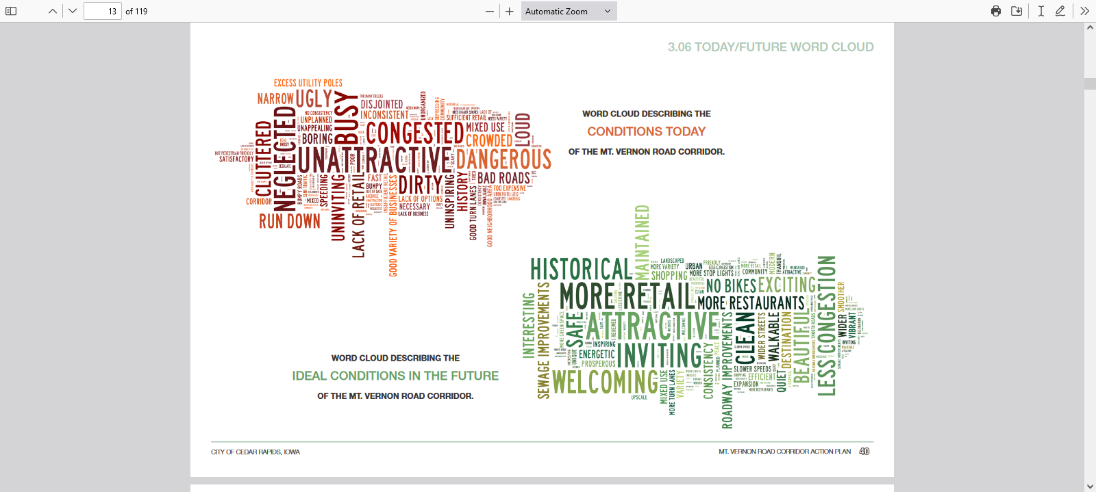
Unsurprisingly, public input sessions on the action plan revealed desires for small retail shops, redeveloping vacant lots, fewer "less neighborhood friendly uses," more separation between residential and commercial areas, turn lanes, and slower truck traffic. Bike lanes were nixed, as bicycling on this road is unsafe and slows car traffic (p. 19).
Word clouds generated by Mt. Vernon Road corridor public meetings
902 28th St: Cute shop for a walkable area
3605: Another vacant property, whose potential changes on a walkable street
The public's desires are reflected in the plan's goals (p 9): (1)
promote new
retail development and redevelopment along the corridor; (2) encourage
neighborhood scale and neighborhood friendly uses; (3) improve traffic
circulation and safety; (4) increase walkability and safety for
pedestrians and cyclists. I expect the immediate pressure to improve
traffic circulation to render the rest of this admirable list
unfeasible. I hope I can explain why.
1841: Neighborhood retail lost to road widening
1901: Neighborhood retail lost to road widening
Neighborhood retail (goals 1 and 2) relies on walkability (goal #4), but that would require Mt. Vernon Road to become smaller and slower (goal #3b but not #3a). The stickler, as the plan's authors admit (p. 11), is that Mount Vernon Road has been developed into an arterial, the collector road for the entire southeast side. The authors claim it has too much traffic already--23000 according to the plan text, 18000 according to the state's average daily traffic counts--for its four lanes, and there are too many driveways for comfort as well.
3303: Even small parking lots are between the (franchise) shops and the sidewalk
Since it is pretty much the only through street in that part of town, there's no reasonable alternative for truck traffic.
3025: More franchises by parking lots
So the road will be reconfigured to restrict left turns across traffic at 15th and 19th Streets; it will end in a roundabout at 10th Street; parking lot access will where possible be redirected to side streets; and cyclists will be directed to alternative routes on parallel streets.
Approaching downtown, new left-turn lane onto 15th Street, creating more distance between core neighborhoods on either side
Cars and trucks will move more swiftly, past locations that could have supported neighborhood friendly uses. (See Herriges 2019 on how arterials work, and don't work.)
1420: Gargantuan c-store, nominally in Wellington Heights
This is the point where I should be telling you what the city should be doing to fix this. I confess I'm at a loss. What are we trying to build here? It's not a downtown, where we go for density, mix the uses, slow the cars, and ignore the parking-obsessed. It's not the suburbs, either, nor is it quite a highway. It's become an awkward mix of all three, so that anything you do to fix an immediate issue with Mt. Vernon Road--narrow it, widen it, add pedestrian infrastructure--is going to make something else worse.
3401: Vernon Village used to have a small grocery and a French restaurant, which then became a bakery/cafe. Now it might be a ghost kitchen?
(I would like to see bus service along the entirety of Mt. Vernon Road, just shooting straight from downtown to maybe Bertram Road and back. Currently, the circuitous Route 2 travels Mt. Vernon Road eastbound from 19th to 42nd, but not westbound. I don't know that it will fix anything detailed above, help the emergence of cute shops, cut down on vehicle speeds, or make walking safer, but it's curious that this has never been done.)
2714: Another auto parts store, next to another vacant building
So, this year my #BlackFridayParking thoughts have wandered far from the subject of parking. But as we see here, excess parking is more than some unproductive government regulation. It is a product of the problematic way we build towns, and how we get around, just as it makes those problems worse. The result is stroads like this one. The parking lots are just the most obvious symptom, or maybe #2 behind the uninspiring commerce.
2000: Used to be an arts center, before that an elementary school
The public comments that informed the Mt. Vernon Road Action plan are not wrong, just naive. It's natural for us to want more of the things we enjoy, with fewer
consequences. Why can't we have smoother traffic flow and plenteous parking, at cute shops, all at a neighborhood scale? Because, beloved readers, in this vale of tears, cars compete with
everything else for space, and the easier we make it for cars to move
the less likely they are to stop, to shop or for any other reason.
2711: Big pharmacy with bigger parking lot
Same building, different side
The
more room we make for cars in the form of parking lots, the less room
there is for anything at a human/neighborhood scale. Anyone
who's paid attention as Mt. Vernon Road has gotten wider and faster
knows this. That's not politics, it's physics.
26th St: One of several cute dead-end streets off Mt. Vernon Road Access becomes more difficult as the road gets faster
18th St: From here to downtown, access is limited by a barrier
Strong Towns video, "Are Parking Lots Ruining Your City" (15:40):
On the southwest side of Cedar Rapids, there is a triangle formed by three stroads: Edgewood Road, Wiley Boulevard, and Williams Boulevard. Average daily traffic counts are roughly 19000 for Edgewood, 9000 for Williams, and (from 2017) 14000 for Wiley. Until about ten years ago, they surrounded Westdale Mall; since that was demolished, they serve a large Wal-Mart, a large Target, and numerous shopping plazas and stand-alone stores.
The area made for an irresistible subject for my 2022 #BlackFridayParking survey, part of the annual Strong Towns event. The area is clearly meant to be driven to; it is served by three bus routes (8,10,12) but the system runs only during the day, and today was running a reduced version of that due to the holiday weekend. Walking between stores is extremely difficult, I can attest. There's a lot of traffic, moving quickly, from various directions. I relied on my remaining agility and the kindness of strangers to get places and return safely to you.
It was a lovely day, sunny and unseasonably warm. I got to Target about 10:00 a.m., too late for the doorbuster sales, but still in time to see a sizeable crowd of cars and shoppers.
Even so, much of the parking lot was unused.
Target, 3400 Edgewood Rd SW, lot 2/3 full at 9:45 a.m.
Down the street at Wal-Mart, the situation was even more pronounced: Many, many shoppers and cars...
View from the front door
...but much unused parking.
Wal-Mart Supercenter, 3601 29th Av SW, lot 1/2 full at 10:00 a.m.
Away from the two retail giants, crowds were thinner and parking lots were emptier.
Strip mall across from Wal-Mart
Kohl's had some traffic near the entrance to their lot...
...but away from the entrance ir was empty.
Kohl's, 3030 Wiley Blvd SW, lot 1/3 full at 10:00 a.m.
The parking lots on the grounds of the former Westdale Mall were glaringly empty.
On the other hand, from a distance it looked like the parking lot of Menards (home improvement store) at Wiley and Williams was very full.
As I forded these lots, I also forded a number of access roads--some, as I said, busy with fast-moving traffic, and some seeing no cars at all. This leads from the Kohl's to Wiley Boulevard, but can only be accessed by southbound traffic.
It made me think that, as much of this event is designed to complain about parking craters, big-box stores and strip malls also generate an excess of infrastructure. Maybe next year we could do Black Friday Access Roads?
Meanwhile, the Westdale area is beginning to see a little of the development promised when the city sunk a fortune into its redevelopment. There is a mixed-use development with apartments.
Parkway West, 3998 Westdale Parkway
These apartments are within walking distance of a lot of shops. I wonder if anyone ever does walk? And what might be the attraction of living here, as opposed to a more human-scaled locale? Price? Highway access?
The apartments are flanked by a hotel (Tru, a Hilton brand) and a construction project that will become a hotel.
Will these projects generate any foot traffic at all? And given the inherent risks of crossing acres of auto infrastructure, would it be a good idea if they did?
And then there's this guy, across from the Westdale bus stop.
Car wash? Oil change? Tire store? It's auto-oriented, in any case, consistent with its surroundings.
The main purpose of Strong Towns' annual #BlackFridayParking event is to highlight to #EndParkingMinimums, provisions of zoning codes that require large stores to have even larger parking lots. Cedar Rapids' zoning code has those provisions, but the parking lots I surveyed seem to be substantially larger than required, albeit I haven't counted spaces.
Even if zoning requirements do not fully account for this appalling design, public policy has a hand in it. Property tax policy allows property owners to pay low rates on large swaths of unproductive land. City officials everywhere have a preference for big "wins," including attracting and accommodating a large franchise operation, over the economic gardening that nurtures local businesses. (See Alter 2022 on the many benefits of small locally-owned businesses over the big-box franchises.)
The result is a car-chocked landscape, full of expensive infrastructure that the widely dispersed businesses ultimately can't support, stressing drivers and practically prohibiting pedestrians. For financial, environmental, and community reasons, we need to do better. We have what we have in unholy triangles like the one I haunted today, but we need to start thinking differently and designing our cities better. As they say at Strong Towns, "Having 'enough' parking is always going to be less important than creating a place people want to be."
SEE ALSO
"Black Friday 2021," 26 November 2021 [Blairs Ferry Road NE from Fleet Farm to Wal-Mart]
"Black Friday 2016," 25 November 2016 [same area that I visited today]
Addison del Maestro, "Unplanned Vacancies," Deleted Scenes, 12 May 2022 [paywall] [which I haven't crossed so it might not be any good] [but he's brilliant so it probably is]
Jaclyn Peiser, "Black Friday Isn't What It Used to Be. Here's Why," Washington Post, 25 November 2022 [another annual tradition is declaring Black Friday "over"] [and indeed it may have run its course, or nearly so] [in the meantime we have all this parking]
The day after Thanksgiving again found me prowling the parking lots of the Cedar Rapids metropolitan area, on my annual mission for Strong Towns, the urbanist organization of which I am a member. (I just got the recurring donation thing figured out, and now I am feeling rather Strong myself!) Strong Towns has been running this event nationwide since 2013, mainly to point out the negative impacts of minimum parking requirements in city zoning codes. Their crowdsourced map started in 2015, a cooperative venture with the Parking Reform Network, includes Cedar Rapids as an example of a city that has removed parking maxima for its downtown (Jordan and Wilberding 2021).
Regulations concerning parking comprise 25 pages of the Cedar Rapids municipal code. They are "intended to ensure that adequate parking is provided
to meet the needs of individual site designs and the
community at-large" (32.04.02.A.1); later the same section refers to "appropriate" amounts of parking. These terms represent value judgments, in spite of the calculations suggested in 32.04.02.B and other attempts at objectivity. They seem to say "You be you, and we'll figure out the parking," but that assumes everyone makes free choices, and those free choices result in the best possible city design. I'd argue both of those assumptions.
The section contains numerous tables defining minimum parking requirements for a given development. General parking requirements (Table 32.04.02-3, pp. 132-134) include two per residential dwelling unit, with less for buildings with small apartments and accessory dwelling units; live-work units are required to have an additional parking space for every 333 square feet of office space. Cemeteries are required to have one parking space for every 50 square feet of the chapel. Elementary and middle schools are required to have two parking spaces per classroom, while high schools are required to have six per classroom plus one per 300 square feet of non-classroom floor space. Want to teach ballet? Studios and instructional spaces are required to have one per 333 square feet. Financial institutions are required to have one per 200 square feet used by the general public, plus one per 600 square feet not used by the general public. This is a fascinatingly granular table, and the effort to compile it must have been impressive.
More importantly, Cedar Rapids now--and I'm pretty sure this is a recent development--has maximum parking rules, as well as exemptions and exceptions to parking minima. Maxima are determined as a percentage of minima (Table 32.04.02-5, p. 135): if 0-49 spaces are required based on Table 32.04.02-3, for example, developments can have no more than the greater of 6 spaces or 150 percent of the minimum number required. Section 32.04.02.F allows exceptions for downtown, and reduced minima for shared parking spaces, residences for the elderly or handicapped, closeness to a bus stop, and connection by sidewalk to trails.
At the very least, this shows sensitivity to the way parking lots waste urban space, and a willingness to develop at least the core part of the city in a way that can serve multiple functions besides car storage. I do not, however, think that Cedar Rapids parking craters are caused by municipal regulation. I think they're caused by the way we do things, at least most of us most of the time, with the ability to ignore people who must or want to do things in a different way. For example, the Blairs Ferry Road Target, in whose parking lot I took three pictures the very first year I did #BlackFridayParking, has 173,941 square feet of retail space, which indicates a minimum of 523 spaces. Maybe I'll count them next year? I'm pretty sure they have a lot more, and were never sweating that zoning regulation back in 2002.
There may be, somewhere in the Cedar Rapids municipal code, an ordinance requiring me to have a second helping of stuffing at Thanksgiving dinner. All that stuffing has analogous negative effects on my physical health to the effects of all that parking on our towns' civic, environmental, and financial health. (Also, by discouraging walking and cycling, too much parking makes us less healthy, just like too much stuffing!) But I'm not stuffing in the stuffing because I'm concerned about an ordinance. I'm doing it because it's what I do on Thanksgiving. Similarly, we build commercial property with gigantic parking lots because that's just what's done.
You be you, drive to Target or Wal-Mart or Fleet Farm, and we'll make sure there's a space for you to park your car. But all this parking is not a neutral engineering/planning response to what people happen to do. It is part of a chain of fateful choices by powerful people that cause the town to develop in a way that driving is what everyone must do.
Fleet Farm, 4650 Cross Pointe Blvd built 2019 189,595 sqft store on 832,867 sq ft lot required parking spaces 570 actual ??
NE edge of the lot
SE edge of the lot
Fleet Farm is a new big-box kid in town. I remember when Chuck Marohn referenced them in his 2015 speech at Iowa City, and multiple people including me corrected him to "Farm and Fleet." We are all aware of Fleet Farm now! There were a lot of shoppers at Fleet Farm this morning, in search of deals like these...
...and they came in a lot of cars, but there was room for plenty more!
Hy-Vee, 5050 Edgewood Rd built 2005 87,524 sqft store on 494,842 sqft lot required parking spaces 263 actual ??
west edge of the lot
Groceries aren't your stereotypical Black Friday purchase, but the lot at this suburban Hy-Vee was nearly full. Elsewhere in this gargantuan plaza, many stores were not open...
It's quite the strip
Another lot of parking
People in this subdivision could walk to Jimmy John's, or Hy-Vee!
Wal-Mart, 2645 Blairs Ferry Rd built 1990 204,266 sqft store on 772,783 sqft lot required parking spaces 614 actual ??
Lowe's is west of Wal-Mart
NW look at Wal-Mart
Sam's Club is east of Wal-Mart
"You could build a small town in that parking lot"-- awed Twitter comment
I did not take pictures of the closer-in sections of the parking lots, so it behooves me to tell you there were a lot of shoppers at all of these stores... just not nearly enough to fill the parking lots. Gigantism of stores and parking lots are a bill of goods sold on convenience and ease of access. It's time to pay attention to what they do to our town's social fabric, fiscal health, &c.
Dunkin' Donuts: I don't understand my fellow humans (Similar scenes at McDonald's and Starbucks)


")
")


")
")
")
")

")
")


