Showing posts with label zoning. Show all posts

Friday, January 6, 2023

Book review: Arbitrary Lines


At Christmas I got COVID and this book!

M. Nolan Gray, Arbitrary Lines: How Zoning Broke the American City and How to Fix It [Washington: Island Press, 2022], xii + 240 pp.

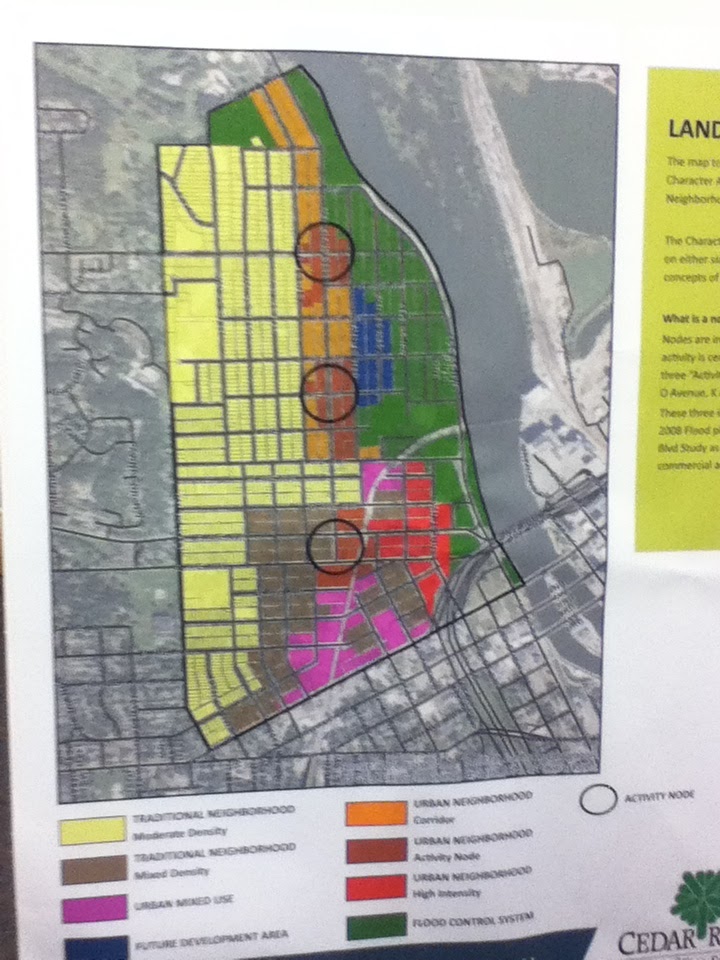
Way back in 2016 I got named to a steering committee for revisions to the zoning code in my city of Cedar Rapids, Iowa. I attended meetings for a bit over a year, then the meetings kept getting scheduled when I was teaching classes, then I went off to a sabbatical. The city now has a form-based code and no parking minima for certain core areas where there is going redevelopment after the 2008 cataclysmic flood. The rest of the city is pretty much the same. I doubt I was much help.

My thought at the time, inasmuch as I'm able to get back in touch with 2016-me, was that zoning reform could accomplish two objectives: (1) by allowing mixed uses, we could reintroduce some vitality to parts of the city and stop some of the destructive features of single-use ("Euclidean") zoning; and (2) by defining the form of construction instead of usage, we could streamline the development process and thereby lower construction costs. Based on our city's updated zoning map, linked here, we may not have gotten there

2016-me would surely have benefited from a hole in the space-time continuum that would have gotten me an advance copy of Arbitrary Lines, a brief but tightly-argued work by New York City-based planner M. Nolan Gray that promises to be the starting point for all future conversations about zoning. (Producing this book involved both Island Press and George Mason University's Mercatus Center, a collaboration I for one never expected to see.) 

In less than 200 pages, Gray makes the case that zoning does more harm than good and should be abolished--no reform, just get rid of it. He notes that zoning was not practiced by local governments until the early 20th century, when a coalition of the privileged--commercial landlords, affluent homeowners, and nativists--deployed zoning to defend middle class areas from incursions by immigrants and the working-class (ch. 1). Subsequently it has operated to protect property values while limiting the supply of housing and making it thereby less accessible and more expensive (ch. 3), limiting movement to areas of the country with high-performing economies thereby restricting individual opportunity and overall growth (ch. 4), restraining racial minorities (ch. 5), and causing more resource consumption and environmental stress (ch. 6). Well, of course it has. 

In chapter 8, Gray makes the case that fragmentation of metropolitan governments means that even the best-intentioned zoning code is going to be manipulable by powerful interests. In chapter 9, he commends the example of Houston, Texas, which has managed to grow quickly and remain relatively affordable while accommodating the well-off and not descending into land use chaos. "Even before zoning," he points out, "Industries need to be where land is cheap and transportation is accessible, and complaining neighbors are few and far between" (p. 152). But he also is pragmatic enough to recommend urgent steps short of outright abolition, including ending single-family zoning, abolishing parking minima, dealing with regulations on minimum floor area and lot size, and allowing single-room occupancy and manufactured housing in city limits.

This is really a lot to pack into a little book. I wish he had dealt with form-based codes, and spent more time on the difficulty of achieving housing affordability when so many people have their principal investments in their home i.e. their golden years depend on housing being less affordable (cf. Hertz 2016). On the latter point, he allows "it suggests a bleak future" and any "gains may be on weak political future" (p. 64). Maybe by spreading information about the social harms of zoning we can appeal to people's better angels? There certainly has been movement in the angelic direction, such as Minneapolis abolishing single-family zoning and Fayetteville liberalizing its ADU ordinance.

Cedar Rapids is a small city with a lot of farmland beckoning us to sprawl further. Maybe we will benefit--our governor says it's already happening--from people relocating from high-demand areas. Gray warns this "at best just buys us time... Absent fundamental reforms, the housing affordability crisis will only spread" (p. 65). So what could Cedar Rapids have achieved, had it decided in 2019 to go Full Houston with its land use policy? Less cost pressure on hot neighborhoods like New Bohemia and Kingston because those developments could be spread around the city? Manufactured homes that aren't on the absolute fringe of the city? Missing middle housing and accessory dwelling units in connected places? Enough density in spots to support better public transit? More intense development closer to surviving public schools?

Hey, a fellow can dream, can't he?

SEE ALSO: "Re-Zone CR Open House," 20 June 2018

Thursday, March 18, 2021

I think this house will be o.k.


It's not often my neighborhood makes the news, but last week the Board of Adjustment was called in to grant a zoning waiver to a house on my very block. The house pictured above, built in 1930, was crushed by an uprooted tree during the August 2020 derecho storm. Earlier this year, the wreckage was cleared away, and now the owners are rebuilding. The lot is 50 feet wide and 140 feet deep.

The first thing you notice about version 2.0 is the garage. The former garage was behind the house, with an alley access. Now there will be a garage that faces the street, with driveway access. This comes dangerously close to the "snout house" design I criticized in October 2016 for infill housing in Oakhill-Jackson. 

It is true that the garage is typically not the loveliest part of the house, and that no other house in our neighborhood has this feature. Even those houses nearby that have driveway access to the street have their garages behind the house. More substantively, as Daniel Herriges (2020) argues, the design creates two problems for any neighborhood: By putting the part where people live behind the garage, it takes away the "eyes on the street" that make pedestrians feel safe, and takes away the signs of human activity that make for an interesting walk.

The traditional city is a sort of social compact. It adheres to certain rules of design not because of aesthetic conformism, but because they produce an environment that is pro-social. The public realm enriches the buildings that front it, and the buildings enrich the public realm.

A front-loading garage, a blank wall, an absent or hard-to-find front door, an over-tall fence around a property: these things spit in the face of that social compact. They send the message, "My world is made up of my private space and the other private spaces I travel to and spend time in." (Herriges 2020)

There is the additional matter that this design feature is prohibited under our town's recently adopted form-based code, as we are "traditional residential-1," at least on that side of the street. (See pp. 215-216.) For that reason the plans were rejected by the Planning Commission, before they were restored on appeal to the Board of Adjustment. Why have a zoning code at all, or a Planning Commission, if we are just going to toss them out as soon as they are challenged by an experienced development team?

That having been said, I'm okay with the outcome. The design of the new house is less aggressive than a lot of the snout houses in subdivisions around our town, and as one of my neighbors noted, it will have a covered front porch and cedar shingles. As troubling as the practice of making zoning exceptions is, I'd have been very o.k. if the owners had decided to build a small store, or a bar, or "missing middle" housing, all of which our neighborhood could use, even if the form deviated from the code. Finally, the clincher is that the owners of the old house are maintaining ownership. If they'd sold the lot to a developer, I'd probably feel differently.

Meanwhile, builders are at work digging the new foundation...

...which is the most excitement our block has seen in a long time. Really, I think this house will be o.k.

Wednesday, June 20, 2018

Rezone CR Open House


Early attendance was light on a stormy evening in Cedar Rapids, as city officials offered a sneak preview of the new zoning plan prior to its official release July 3. Form-based zoning will be applied in a small section of the city (see map above). I was on the Steering Committee for the rezoning, but have had no role in its content.


A few quick reactions:

1. This is the right part of the city on which to try this: older, already-urban areas that have seen considerable redevelopment since the flood. For the most part, the redevelopment has reinforced rather than challenged the traditional pre-Euclidean form of these areas. If form-based zoning works here, perhaps it can be extended to the adjoining core neighborhoods: Mound View (soon to be the object of the College District Action Plan), Wellington Heights, the Taylor Area and the Northwest. Beyond that the city's form is predominantly suburban, and it's hard to imagine much change from that is likely.

2. Outside of downtown (the red area on the map), there seems to be a good balance of mixed use (orange) and purely residential (baby blue). It looks like no one in this part of the city will live more than three blocks from a commercial establishment, albeit may be one that sells auto parts when you need a loaf of bread.

3. The area between 7th and 10th Streets East is designated "Urban Neighborhood General Flex"--essentially, mixed use with taller buildings--which seems appropriate for the area between downtown, the hospitals and the neighborhoods. Whether it actually develops that way depends on the acquiesence of the hospitals and Physicians Clinic of Iowa, which have so far been powerful forces behind anomalously suburban-style development. Another old house came down today, in fact:
Image may contain: house, sky, tree and outdoor
Photo by Cindy Hadish, from Save CR Heritage Facebook page
This could, of course, make way for new construction, but the clearances seem intended for another parking lot.

EARLIER POST: "Re-Zoning Cedar Rapids," 4 December 2017

Monday, December 4, 2017

Re-Zoning Cedar Rapids

Community residents at ReZone Open House,
New Bo City Market, October 2017
Cedar Rapids's adoption of form-based zoning will be targeted in scale and proceed incrementally, according to city planners Seth Gunnerson and Anne Russett. The two spoke last week to the Corridor Urbanism group, following an input-seeking open house in mid-October. (I am a member of the ReZone Steering Committee, which has met occasionally since March 2016 to discuss formulation with planners and the consultants from SAFEbuilt Studio.)

ReZone Cedar Rapids grew out of the city's comprehensive plan adopted in 2015. Form-based zoning is being applied first in the downtown area, as well as four nearby areas that had previously been designated as zoning overlay districts allowing for relaxation of existing zoning rules: Czech Village/New Bohemia, Ellis Boulevard on the Northwest Side, MedQuarter and Kingston Village. The intent is to follow through where there has been ongoing focused planning efforts; these areas can then serve as models for other areas where occupants may seek focused planning in the future (such as the College District).
Citizen suggestions at the open house for future form-based zones included
Mound View/College District (center right cluster)
and along the Highway 100 extension (far left)
The area created by the extension of Highway 100 is currently a blank slate, and currently under the jurisdiction of Linn County, but is likely to be annexed by the City of Cedar Rapids before development, so form-based zoning and even walkable urbanism are open possibilities there. This poster...
...presented by H.R. Green Engineering at a city open house in March 2014 suggested walkable urbanism was at least being considered for future development along Highway 100, albeit there were two other posters there too.

Gunnerson and Russett explained that form-based zoning centers on the form and size of buildings rather than separating uses (residential, commercial and industrial being the three main traditional categories). The code also describes street networks and multiple access, neighborhood character and the relationship of buildings to streets.
Dot stickers indicated citizen support
Typically form-based regulations have buildings fronting the streets rather than existing behind parking areas...

...or green space, and describe pedestrian scale infrastructure like lighting...

and signs...

...although any form including large-lot suburban subdivisions can be part of the code.

The reasons to change the zoning code, besides encouraging more traditional walkable development, is to allow more options for neighborhoods beyond single use, update zoning that is often decades old and not descriptive of certain areas, and simplifying the process of approving or disapproving developments.

The first draft of the code is due this winter; the revised draft following public feedback will be presented to the City Council in summer 2018. The new codes may take effect immediately or be phased in over a number of months.

My guess is the average Cedar Rapids citizen will not notice much impact from this zoning change. In the targeted districts certain types of building will be restricted, but other types can be expedited. Over the long term we can hope for better economic development in those economically-important districts, and aroused public interest in attempting form-based zoning in other parts of the city. I'm more hopeful about the first than about the second.

CORRECTION: The discussion of property along the Highway 100 extension has been amended to clarify the probable sequence of annexation and development i.e. previous false information has been replaced by true information.

MORE! MORE! MORE!

City's promotional "trailer":
The city's Rezone website contains display boards as well as results of public input.

SEE ALSO:
"What is a 'Form-Based Code' and Other Mysteries of Zoning," 7 March 2016
"Envision CR Open House," 26 March 2014

Sunday, February 12, 2017

Urbanism updates: Northwest side and 8th Av SW

The Flamingo Restaurant on Ellis Boulevard: Better days ahead?
City development staff have held two public presentations this month, on the Northwest Neighborhood plan and the 8th Avenue SW project.

The Northwest Neighborhood, though dealing with economic change and the 2008 flood, remains a vibrant community of small homes dating from its heyday as a home for working class families. Homes remain west of Ellis Boulevard (yellow on the map above); the area between Ellis and the river (green on the map) was particularly hard-hit by the flood...

The city bought and demolished the vast proportion of the houses there, and plans a series of riverfront attractions as well as flood protection.

Once flood protection is in place, the city hopes to attract infill housing of various types along and south of Ellis. With enough population around, Ellis itself can again become a thriving commercial area. Some of the residents who were present at the meeting at St. James United Methodist Church recalled walking to the A&W (now closed), the Flamingo Restaurant (now open one night a week as an events center) and other attractions.

Bicycle routes and bus lines will link the neighborhood to the rest of the city, and the rest of the city to the greenway.

8th Avenue SW is due for resurfacing and sewer replacement, which is mostly routine (albeit not if your house is near where they'll be working). City officials announced a couple of new features of general interest. The first is a sidewalk along the north side of the street, which serves Veterans Memorial Stadium, tennis courts, Trinity Lutheran School and Cleveland Park, as well as many residences.

The sidewalk is an important addition. Although it's across the street from the ball park, people walking to the stadium are now "hung out to dry" while they wait to cross 8th. The new sidewalk will give the a place to stand, and the bumpouts will give them a clearer shot across the street. The representative from Trinity Lutheran School suggested that parents parking on the street for school events will have an easier time getting to the school along the sidewalk. There was no resident opposition, in large part because the city plans to stop dunning homeowners for the cost of installing new sidewalks. This is a very favorable development. Sidewalks, like streets--maybe moreso?--benefit the entire city, and should be funded accordingly.

The city also plans a stormwater detention facility at the intersection of 8th and Rockford Road.
At present eastbound through traffic on 8th curves to the right as they approach Rockford, but an offshoot is used by people turning left onto Rockford. This creates a triangle which is currently just grass. The city plans to close part of the offshoot, and to design catch basins in the green space.

Next to me at the meeting were an adorable woman and her even-more-adorable mother, who live next door to each other in the 1500 block of 8th and who have lived in the neighborhood for decades. The woman asked the guy from the city if it wouldn't be nice to have a rain garden in the space. He asked, with some irony, if she wanted to maintain it. She said, with utterly no irony, that she and her mother did indeed want to maintain it. So they took her name and number, and this may well happen. Every now and again, the human race makes your day!

Monday, March 7, 2016

What is a form-based code? and other mysteries of zoning

Zoning map from 1920s Winnipeg (Source: Wikimedia commons)

One of the forces that has gotten us into the fix we're in--sprawl-wise and society-wise--is single-use (Euclidean) zoning, which originated over a hundred years ago with the idea of keeping polluting and noisome businesses (factories, slaughterhouses) well separated from where people were trying to live and raise children and such. I don't want to live next to a smokestack anymore than you do, nor do I want to live next to a slaughterhouse, nor when it comes right down to it a baseball stadium or an amusement park. So far, so good.

This laudable beginning, however, led to more dubious efforts to classify and separate. As Andres Duany and his co-authors explain:
This segregation, once applied only to incompatible uses, is now applied to every use. A typical contemporary zoning code has several dozen land-use designations; not only is housing separated from industry but low-density housing is separated from medium-density housing, which is separated from high-density housing. Medical offices are separated from general offices, which are in turn separated from restaurants and shopping. (2000: 10)
Local zoning laws, long helped by federal housing policies, have contributed to the state of the American landscape that is familiar to nearly everyone reading this: large-lot subdivisions located from far from anything anyone does; shopping malls and strips on congested roads; much of the day spent in motor vehicles, stuck in traffic jams or running errands in "Mom's taxi;" a vast sea of parking lots; inner city slums isolated from productive places; the gradual disappearance of third places; and financially-pressed cities and states scrambling to keep up with it all.

Nowadays we know a lot about how these systems work. The public may not be pushing for change: there's a tendency to regard this landscape and the burdens it places as part of the natural order of things, and those with a disproportionate share of economic and political clout may well be glad to be well away from everyone else with all their problems. Duany et al. note: "It has been well documented by Robert Fishman and others how racism was a large factor in the disappearance of the middle class from the center city ("white flight"), and how zoning law clearly manifests the desire to keep away what one has left behind" (2000: 11n).

But there are signs of change. Younger people are showing more interest in urban living, and city governments want to make their places both more appealing and more financially-solvent. Now the same zoning codes which were used to sell development are seen as obstacles. Their rigid rules and formulae restrict individual choice and community adaptation. Whatever to do?

One trend is to wider use of form-based codes. The Form-Based Codes Institute, a non-profit planning organization headquartered in Washington, D.C., defines this concept as
a land development regulation that fosters predictable built results and a high-quality public realm by using physical form (rather than separation of uses) as the organizing principle for the code. A form-based code is a regulation, not a mere guideline, adopted into city, town, or county law. A form-based code offers a powerful alternative to conventional zoning regulation.
In other words, a form-based code focuses on outcomes like the look and feel of a place, rather than on what goes on there. Of course, a community could decide that it prefers the look and feel of a large-lot subdivision, but presumably the motivation to adopt a form-based code would be to seek to achieve an integrated vision not possible with single-use zoning. Cincinnati, Ohio, whose code won an honorable mention from the organization in 2014, provides for a city-wide network of walkable neighborhoods, with standards for building and frontage types, based on the transect (see below), but encouraging neighborhoods to produce their own plans. More recently, three first-ring suburbs of Chicago collaborated on form-based building standards for Roosevelt Road, a highway that runs through all three. In a 1.5-mile stretch, there are pedestrian zones and transitional zones, as well as an auto-oriented zone close to Harlem Avenue, but all emphasize pedestrian safety:
Roosevelt Road form-based code 2014
Roosevelt Road form-based code (swiped from formbasedcodes.org)

The FBCI sites includes examples of codes, webinars and opportunities to register for more intensive conferences.

Communities can consider the natural flow of the transect, which is one way that a form-based code can be organized. The transect is a series of gradual transitions from open/rural spaces to the dense urban center, intended to model a natural transition from, say, seafront to forest. The zones are based on character, form and intensity of development. Basing city zoning on this concept is intended to "provide the basis for real neighborhood structure, which requires walkable streets, mixed use, transportation options, and housing diversity," instead of forcing people to drive great distances to get to separated uses. "The T-zones are intended to be balanced within a neighborhood structure based on pedestrian sheds (walksheds), so that even T-3 residents may walk to different habitats, such as a main street, civic space, or agrarian land."

transect
Source: Center for Applied Transect Studies

The Center for Applied Transect Studies website includes model transect-based codes and modules, as well as--particularly useful for non-planners like me--a photo gallery of examples from the different T-zones. While CATS focuses on municipal zoning, I think this concept would be more relevant to metropolitan regions where there still are natural and rural zones.

Cities may also seek to encourage development of missing middle housing. Designer Daniel Parolek coined the term "missing middle" to denote "a range of multi-unit or clustered housing types compatible in scale with single-family homes that help meet the growing demand for walkable urban living." These are "missing" because of unmet demand, estimated by Arthur C. Nelson in a 2014 conference paper at 35 million units. Missing middle housing includes duplexes, fourplexes, small multiplexes, bungalow courts, townhouses, courtyard apartments, carriage houses, and apartments-attached-to-workplaces. (See website for examples as well as advice to designers.)
Missing middle housing on the transect
Source: missingmiddlehousing.com

Single-use zoning leads to the lack of such development. Parolek notes: (1) codes usually skip from single-family detached homes to apartment complexes which tend to be large; (2) they don't allow for blended densities; and (3) lack of flexibility in parking and open space requirements discourages smaller units. A form-based code, on the other hand, can create a range of housing types compatible with the community's vision.
Then for each form-based zoning district a specific range of housing types is allowed. For example, in a T3 Walkable Neighborhood a single-family detached type, bungalow court, and side-by-side duplex may be allowed, or a urban T4 Urban Neighborhood zone would allow bungalow courts, side-by-side duplexes, stacked duplexes, fourplexes, and the multiplex: small type, even though the densities of each of these types can range dramatically. Each type has a minimum lot size and maximum number of units allowed, thus enabling a maximum density calculation as the output. (missingmiddlehousing.com)
Cedar Rapids, which lost a lot of housing and commercial buildings to a massive flood in 2008, may have more opportunity than most cities to remake its landscape. Even here, change will come slowly. The main idea is to remove from the law persistent obstacles to traditional, human-scaled development, and where possible to use the zoning code to shape development in the community interest.


WORKS CITED
Andres Duany, Elizabeth Plater-Zyberk and Jeff Speck, Suburban Nation: The Rise of Sprawl and the Decline of the American Dream (North Point, 2000)
Robert Fishman, Bourgeois Utopias: The Rise and Fall of Suburbia (Basic, 1987)
Arthur C. Nelson, "Missing Middle: Demand and Benefits," paper prepared for Utah Land Use Institute conference, 21 October 2014

WEBSITES  
"Center for Applied Transect Studies," http://transect.org/
"Form Based Codes Institute," http://formbasedcodes.org/
"Missing Middle: Responding to the Demand for Walkable Urban Living," http://missingmiddlehousing.com/

JUST PUBLISHED! Ryan Holeywell, "How the 'Missing Middle' Can Make Neighborhoods More Walkable," Urban Edge, 29 March 2016

The authoritarians' war on cities is a war on all of us

Capitol Hill neighborhood, Washington, January 2018 Strongman rule is a fantasy.  Essential to it is the idea that a strongman will be  your...