Showing posts with label Minneapolis. Show all posts

Saturday, March 29, 2025

Minneapolis Skyway

posted list of services available on the Skyway at 250 2nd Av S
Minneapolis Skyway service directory, 250 2nd Av S

In only my third post on this blog I confessed my love for Cedar Rapids' Skywalks, which connect a few downtown office buildings between the Doubletree Hotel and the Ground Transportation Center. During a sabbatical that spring, I had walked the Skywalks every day while working out of the downtown library's temporary location. Now that I'm (mostly) retired, I find I can from end to end and back in thirty minutes, a good fitness walk.

During that same sabbatical, I read Suburban Nation for the first time. Authors Andres Duany, Elizabeth Plater-Zyberk, and Jeff Speck excoriated skywalks (or "pedestrian bridges") for taking pedestrians off the streets and for separating middle class workers and shoppers from poor people. (See chapter nine for their critique.) I defended my love by saying the twists and turns of Cedar Rapids' Skywalks make them impractical for most pedestrians, and that they put me into historic buildings I would have no other occasion to enter. (At the time those included the American Building, which has since been closed off from the system by United Fire Group.)

The Minneapolis Skyway operates on an altogether different scale. Its various paths and spurs total about ten miles, and cover more than 80 blocks. While Cedar Rapids has a couple of law offices in its skywalks--the Armstrongs Department Store that once was its hub closed in 1990--Minneapolis has restaurants and bars and stores and hair salons and on and on, besides connecting to a Target store. It also connects to US Bank Stadium, home of the NFL's Vikings, and Target Field, home of MLB's Twins.
younger version of author with statue of Twins star Tony Oliva
Target Field: me and Tony Oliva, 2016
(got there by light rail not Skyway, though)

We didn't come close to covering all ten miles of Minneapolis Skywalks, nor to Target Field. We began our ramble at the Minneapolis Central Library:
sign at bottom of escalator indicating skyway access
Getting to the Skyway from the Minneapolis Central Library

Some though not all ramps have street signs...
Skyway ramp with street sign

...and wayfinding signs...
Skyway wayfinding sign

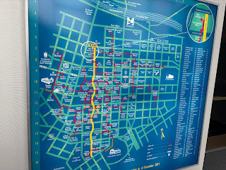
...and there are frequent maps, though not so frequent that one doesn't get lost (part of the Skyway experience, say the websites). East is up on the maps, instead of north, which can be disorienting.
Skyway map
Skyway map 

I'd suggest taking a middle schooler up to the Skyway and giving them some place to lead the group. As soon as they go wrong, put a map or at least a sign there.

The Skyway system is notable for its extensive commercial operations, including cafes...
Skyway cafe
Skyway cafe

...and clothes shops...
Skyway boutique
Skyway boutique

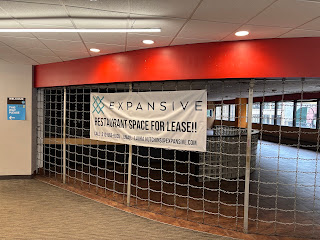
...and offices, and barbershops, and all manner of other stuff. There's room for more!
Skyway vacancy at 215 S 4th Street

There are apartments like this one off the Skyway, though I couldn't tell if it actually was connected.
Apartment and courtyard by Skyway

A directory of condos that are connected is at homesmsp.com.

Not all parts of the Skyway are hotspots. Some parts were just tubes...
Skyway empty tunnel
Skyway empty tunnel

...where the lack of "eyes on the Skyway" can be uncomfortable.
Skyway empty tunnel sign

It felt weird sky-walking into the Public Safety building. I wonder if other people feel that way?
Skyway entrance to Public Safety building
Skyway entrance to Public Safety building,
401 4th Avenue S

Eventually we found our way back to our hotel, which like most if not all downtown hotels and parking garages is connected to the Skyway.
Skyway ramp leading to Westin Hotel, 88 S 6th St

Most of the Skyway is open only during normal business hours Monday through Friday, so we're not establishing an alternative society here. I don't know whether I am happy with that (allows street life to flourish at other times) or would like more extended hours (my rental van was accessible by Skyway until Sunday morning when I needed it).

For dessert, here's a homey scene I found on the way to the parking garage:
50s kitchen display, with cherry pie on table
50s kitchen display, Northstar Center

Skyway guide at minneapolis.org
Skyway performed by songwriter Paul Westerberg (2:18)


Saturday, March 16, 2024

Human transit in the Twin Cities


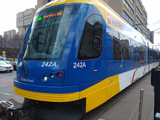
front view of light rail train car
Green Line departing East Bank stop

Jarrett Walker, Human Transit: How Clearer Thinking about Public Transit Can Enrich Our Communities and Our Lives (Island, revised ed, 2024)

Jarrett Walker is out with a new edition of Human Transit, first published in 2011. Walker is a transportation planner, consultant and blogger from whom I've learned a lot about what works and doesn't when it comes to public transportation. I particularly appreciated his insight, explored in the first edition, that any transit system faces a tradeoff between frequency, coverage area, and the ol' budget. Since I've already used those insights to analyze Cedar Rapids transit, and since I had cause to be in Minneapolis this week, it's a chance to examine Walker's ideas in light of the Twin Cities' Metro Transit, a system with which I'm relatively unfamiliar. As it happens, Walker consulted in the Twin Cities, albeit quite a few years ago (Walker 2009).

The fundamental problem addressed in Human Transit is how to move large numbers of people within a small space. Walker refers in the introduction to three efficiencies of transit over cars--space, labor (one driver for many passengers), and strain on the environment (2023: 15)--and pollution, climate, and public health concerns get a few mentions elsewhere in the book, but essentially we're asking how to make the transit we can afford work for the people we've got. It takes as written the aggregation advantages of cities, and that people are living in dense metros for those very advantages.
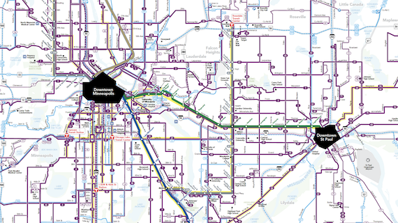
Twin Cities transit map
Metro Transit system map

Even in densely-populated cities, most people must have positive reasons to take transit. Walker focuses on seven common "demands" (expectations) in ch 2:

(1) Connectivity. Are the stops convenient enough to my home and destinations that I can leave the car in the garage or not have a car at all? If I can't get where I'm going on a single line--unlikely in an efficient system consisting of multiple straight lines--are connections easy to manage? 

This is especially hard for a tourist to judge. We stayed at the Graduate Hotel, three blocks from the University of Minnesota's main campus, and kitty-corner from the East Bank station on the light-rail Green Line. We took the Green Line east to the A-Line BRT, then rode that line south to Grand Avenue, at the entrance of Macalester College. The transfer to the A-Line was a bit tricky, as it involved walking swiftly across both University and Snelling, both wide and heavily trafficked streets, to get to the bus stop. 

busy intersection, cars, old buildings
View from the bus stop on an A-Line;
despite the important transit junction, the area is noticeably rundown

On the way back, we took the #63 bus to meet the Green Line at Raymond Avenue. It was not noticeably longer than the journey there, particularly because the train came almost as soon as we got off the bus.

(2) Span and frequency (covered in ch 8). Does the system run enough of the day that I can get to work or school and maybe evening events?

The first St. Paul-bound train on the Green Line rolls through East Bank at 5:21 a.m. Trains come every 15 minutes beginning at 6, only slowing down at 10:30 p.m. The last train arrives at 11:36. Saturday and Sunday schedules are pretty similar.
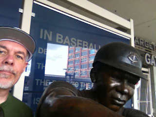
Bruce Nesmith with a statue of Tony Oliva
In 2016 I took the Green Line to its terminus at Target Field where I ran into Tony Oliva

The A-line has a longer day, with the first southbound bus at Snelling and University at 4:15 a.m. and the last at 12:15 a.m. The first #63 bus arrives at Snelling and Grand at 5:15 a.m. and the last at 1:15 a.m., running every 15 minutes from morning through evening rush hour. The different start/end times are curious.

(3) Time. How long does it take to get where I'm going, including and maybe especially the time to get to the station and wait for the bus or train to arrive?

According to Google Maps, it takes 33 minutes in mid-afternoon to get from our hotel to the Macalester College campus by transit, as opposed to 14 by car. If we add in an average wait time of 7.5 minutes for the train, we're at 40.5, plus managing the transit. We got to the East Bank light-rail station just as a train was pulling out, so we waited the full 15. We had about 7 minutes on Snelling Avenue once we'd navigated the intersection, though it seemed longer in the scruffy surroundings, so the total was about 45 minutes.
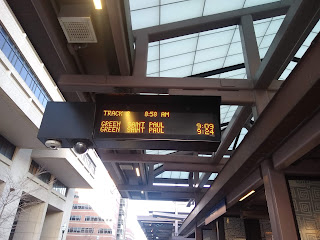
sign says next train in 11 minutes
Waiting for the train at East Bank

A 45 minute transit run in lieu of a 14 minute drive was still worth it for me, the tourist, because I didn't have to deal with traffic and parking. But if I worked at or near Macalester, I'd probably have my own parking space. (In Washington, D.C., by comparison, the transit time to car time ratio outside of rush hour is maybe 2-1 instead of 3-1.)

(4) Fares (ch 11). How painless is it to pay to ride? For regular riders, there are 7-day and 31-day options which can be loaded onto one's plastic Go-To Card. For tourists, an all-day pass is $5, good for both rush hour and non-rush hour, and usable on all local lines. (A single ride is $2.50 during rush hour, $2 otherwise.) 

I bought my all-day pass on the Metro Transit app, so it was on my phone, while Jane bought a paper ticket at the East Bank station. 
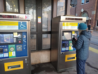
Fare kiosks by the train stop
Fare kiosks

The all-day pass allowed us to transfer without additional payment, and to stop on the way back at the Textile Center across from the Prospect Park train stop. Our different modes of ticket purchases were about equally painless...

all-day pass and credit card receipt
All day passes are $5 on weekdays, $4 on weekends

...but anyhow fare collection on Metro Transit appears to be on the honor system. If you have a Go-To Card you can tap in at the station, but you can't do that with phone or paper; anyhow there's no barrier to prevent non-payers from entering the vehicles.

(5) Civility, mainly of station agents and conductors, but I'd include conditions on the bus or train. Because of the seemingly lax enforcement, we had no interactions with transit employees. Conditions on the vehicles we rode Friday (three separate light-rail trains, one A-line bus, one #63 bus) were a mixed bag. 

Interior, eastbound light rail train

None of the vehicles was crowded, as we did start our travels til after 9:00 a.m. There was a strong marijuana smell on two of the trains, and one train had several passengers who were clearly living temporarily in the train cars. Saturday night on my way back to the hotel on the Green Line, I unwittingly boarded into a drug party that was well underway; I debarked as soon as I could, and trotted to the next car which proved to be a better fit.

(6) Reliability. Can I count on the system to get me where I'm going on time? The vehicles were all on time or very close to it, even though we heard announcements that the Green Line was running slowly due to track issues.

(7) Legibility. If I change my plans at the last minute, is it clear what my new route is? I'd use the Maps app on my phone rather than try to use system resources, whatever city I was in. There aren't system maps about in the Twin Cities, or even route maps for the light rail or BRT. 
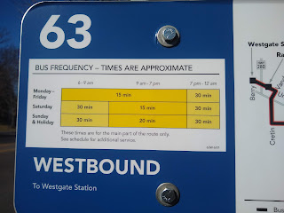
sign posted with bus times
Grand Avenue and Snelling: when the bus comes

From my quick tourist's glance, it seems Minneapolis-St. Paul's Metro Transit is doing a lot of things right. The system is easy to use, and mostly comfortable to ride. Even so, for our Saturday tourism, we used our car. Getting there in a-third of the time is irresistible, even for urbanists.

SEE ALSO: 

Ian Guide, "We Need to Talk About Bus Rapid Transit Creep," Streets.mn, 12 March 2024 [The A-line BRT is not BRT. It shares lanes with private cars, and stops at traffic lights. The only way it's special is it makes fewer stops than an ordinary bus, which makes it an express bus, not BRT. On the other hand, the University circulators, one of which I took Saturday night, run much of their route along a "transitway" that is closed to private cars.]
 
Diana Ionescu, "How Public Transit Became Political," Planetizen, 14 March 2024 [includes article to longer article in Governing]
 
 
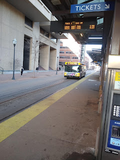
bus approaching East Bank light rail stop
Washington Avenue: Both metro and university buses drive along the light rail track,
which is ever-so-gently separated from the street

Wednesday, October 16, 2019

A corner of urbanism

Visiting our son in Minneapolis last weekend, we found a delightful (and very popular) coffee/brunch place in a residential neighborhood in the southeast part of the city, near Lake Nokomis. I was struck by the activity and range of businesses at the corner of 52nd Street and Bloomington Avenue. From the surrounding neighborhood, a person could walk to the cafe as well as an insurance office, dentist, bookstore, plus-size closing store, and a Masonic temple.

That won't fill all your daily needs, of course, but it's a pocket of semi-walkability that is rare in my town. The residents have ready access to a small variety of things, but have to tolerate customers parking on their streets...

 ...maybe especially on Sundays at 10, when half the city seemed ready to pack itself into the Hot Plate--and the rest took refuge in the Irreverent Bookworm across the street. I mention this because traffic and parking are automatic objections whenever someone tries to make a neighborhood more walkable. Those are not irrelevant, but can't become absolute values in a walkable, inclusive community. For a little inconvenience, look what you get!


You could argue that the neighborhood is unusual. The Hot Plate is in Census tract 117.03, which is well-off (med income of $47423/yr puts in the top 10 percent of census tracts nationally), but is densely-populated (4252 people in 0.67 sq mi=6338/sq mi) with people who have chosen an older neighborhood (median home construction is 1939). Nevertheless, people have chosen to live in a place like this, and if such choices were available elsewhere they would be chosen there as well.


SEE ALSO:
"Letter from Washington (III)," 3 March 2018
"Envision CR IV: Neighborhood Stores," 28 May 2015
"Indulging in Urban Fantasy," 6 September 2014

Friday, January 4, 2019

Three questions for places in the New Year

building on snowy street
Cedar Rapids winter overflow shelter
(swiped from cbs2iowa.com)

1. Can we do better by our mentally ill and addicted citizens? People living on the streets are a constant of urban places, even in smaller cities like Cedar Rapids. Of the cities where I spent time, Seattle seems to have the most aggressive street people, including one fellow downtown known for periodically shouting at no one in particular, "Excuse me, sir? SIR? SIR? FUUUCK!" There have been reports of urinating in front of stores, and following other people for blocks. No wonder Seattle's mayor called homelessness "an emergency" a few years ago (Treatment Advocacy Center 2016). But variations of these phenomena are found everywhere. In New York City last month, a police officer was attacked by three homeless men.

One plausible if somewhat-dated estimate had the homeless population with severe mental illness at 325,000 (Treatment Advocacy Center 2016).  Homelessness comes in many forms, and much of it is driven by issues of supply and affordability. People living on the streets are often mentally ill or addicted to substances (which are not mutually exclusive categories). Nationally, estimates range around a third of homeless who are severely mentally ill, though local studies have found higher proportions (Baldwin 2016). (People who are homeless for economic reasons tend to be less visible to the general public, and probably to researchers, too.) Their situation has been exacerbated for decades by deinstitutionalization and closing of psychiatric hospitals, driven by state budgets as well as idealism.

While institutionalization is not the solution for everyone, neither is it compassionate to allow people to drift and struggle, facing perils of crime, weather and eating food from dumpsters. Can we improve access to addiction treatment and antipsychotic drugs? Provide better transitional living situations? Support more research into causes and cures? Meanwhile, we rely on short-term heroic solutions like shelters, or try to law the problem away by making sleeping on the streets a crime.

Downtown Washington, Iowa

2. Is there potential for economic development in small towns and rural areas? This is a question we've visited before, but with the imminent reconvening of Iowa's office of rural affairs (a.k.a. the state legislature) it's worth looking at what might be done for underperforming areas besides tickling their feelings of resentment with culture wars bills.

A recent Brookings study argued that small towns and rural areas might do best by cooperating with nearby small cities (Arnosti and Liu 2018). If our economic future is going to be anchored by digital and knowledge-based skills, policies to revive extractive industries like mining should be recognized for the false promises they are; instead, "rural America's best bet might be to support economic growth in urban centers, including micropolitan areas, and strengthen linkages between urban and rural communities." Successful metros can and do subsidize projects elsewhere in the state; successful metros near rural areas improve access to jobs and capital for rural residents while retaining social connections; and some of those taking advantage of nearby opportunities will return to their hometowns (the "boomerang" effect). Richard Florida (2018) notes that not all rural counties are suffering population and job loss, though the examples he cites--a Tesla factory in Storey County, Nevada; an expanded casino in Love County, Oklahoma; and an expanded retirement community in Sumter County, Florida--smack of smokestack-chasing and so may be limited in their instructive utility.

Arnosti and Liu approvingly quote Bloomberg columnist Noah Smith, who argues, "In order to compete with the big cities, rural America needs fewer factory towns of 5,000 people and more small university cities of 50,000." They argue states should (1)  empower communities' and regions' capacity to chart their futures; (2) prioritize local job creation over recruitment of firms like Tesla or OCI NV; (3) strengthen post-secondary education; and (4) seek to close regional disparities. There's a lot there to choose from; we'll see if Governor Reynolds or the Iowa legislature pursues any of it, or sticks to the ever-popular culture wars.

heroImage.Alt
(Photo by Tela Chhe, from flicker.com via minneapolis2040.com)

3. Can Minneapolis 2040 [a] work? [b] serve as a model for other cities? In December 2018, the Minneapolis City Council passed a new comprehensive plan. Most notable among its many topics, the plan calls for policy changes that could conceivably have an earth-shaking impact on housing supply and affordability by allowing duplexes, triplexes and apartments in a vast area of the city where they are not currently permitted (Schuetz 2018, Sisson 2018). If it plays out as hoped, the increased density will produce substantial improvement in the city's environmental footprint, better community connections, an opportunity for all those people who say they want to live in walkable communities actually to do that, and more fiscally-sustainable infrastructure. As Strong Towns Tweeted: Minneapolis 2040 will undoubtedly have a huge impact on economic justice and the affordable housing landscape. But allowing neighborhoods to adapt and grow incrementally will have an even bigger impact on something more fundamental: pure finance. 

Other cities, starting next door with St. Paul, are looking at what Minneapolis has done and are preparing to ask their doctors if Density might be right for them. But there remains much work to be done to turn this legislative miracle into on-the-ground reality.


Anyone who follows politics knows that the fight doesn't stop with enactment; it just rolls across the street to a new bar. The zoning code will need to be changed to incorporate the new goals i.e. to make them legal. As in any place facing housing issues, landowners and developers will need to be assured there's profit to be made in these kinds of projects. And specific projects are sure to be protested by affected neighbors (Schuetz 2018). On the other hand, new Mayor Jacob Frey chose to spend his political capital on passing this, and it did pass, and that alone represents an intriguing new page in this story.


Wednesday, February 17, 2016

Mass transit, here and there


What should be the future of public transit in the Cedar Rapids area? There's still time to add your comments at http://corridormpo.com
Ideas were rolling at two public open houses for the 2016 Corridor Metropolitan Transit Study, hosted by the Corridor Metropolitan Planning Organization yesterday at the Ground Transportation Center in downtown Cedar Rapids.

Passengers disembark at the Ground Transportation Center (photo by Ben Kaplan)
Multimodal transportation planner Brandon Whyte, who was on hand along with regional transportation planner Hilary L. Hershner, said the gatherings were for "looking at ways to improve transit in the metro." Attendance wasn't huge, but there was no shortage of people willing to fill out surveys. There will be a second open house in April.

The transit operation provided ridership data for the various lines.

The chart shows annual figures; about 4300-4400 people ride the bus on an average day. Assuming those are unique persons, that's about 4 percent of the population. Saturday ridership is lower, but is up since they eliminated fares.
Transit director Brad DeBrower said they couldn't tell if those were new riders or just regular riders riding more.

 Some lines (marked in red on the map) have considerably more ridership than the others...

...with numbers for the lines that serve the southeast side on which I live rather modest.

So they're aware of ridership data and can respond to them, although they are not tipping their hand as to how radical a change they're willing to undertake. The money isn't there, either from federal or local government, to expand service, either hours (service runs from before 6 a.m. to after 6 p.m.) or number of buses (most lines run one bus per hour).

There were displays of better bus stop infrastructure.

Whyte touted the electronic apps that make the service far more user-friendly. RideCRT allows the user to see all active buses in the entire system in close-to-real time, and get an expected time of arrival for the nearest stop. (And, I can confirm, it is compatible with older versions of iOS.)

Google Transit integrates the transit system with Google maps, enabling the user to plan travel routes including options for bus routes and departure and arrival times.
Multimodal transportation advisor Brandon Whyte explains the new functions

Since they asked, here is my vision for transit. I assume (a) public transit is an important alternative to the private car, particularly for the poor and handicapped, but also for environmental reasons; (b) funding for ongoing operations is not going to balloon any time soon, and in fact may become more constrained given fiscal realities at the national level; (c) the dispersal of residence and business locations that occurred during the age of sprawl is going to correct itself slowly, if at all; and (d) government agencies serve no one well if they spread themselves too thin. SO, I would:
  • Contract the system by about half in each direction from the center of the city. I'm sacrificing complete coverage for quality coverage of the more densely populated areas. Instead of covering the entire city with 1100 bus stops, it would cover about 1/4 of the land area. I'd make exceptions for places of high value outside of this area, like Kirkwood Community College and Uptown Marion.
  • Replace our loopy routes with more direct lines along major thoroughfares like 1st Avenue, Mt. Vernon Road, 16th Avenue West, and the like. Buses could then compete with cars for travel times. If we could arrange some dedicated lanes, so much the better.
  • For the same reason I'd thrown in some express routes to Kirkwood and Uptown Marion. Maybe some others?
  • Somehow we would have to accommodate those people with physical and mental handicaps who because of where they live would lose ease of access in a contracted system.
Transportation for America
For further imaginative fuel, the national group Transportation for America this afternoon released their new resource for integration transportation policy into place making, "The Scenic Route." Creative placemaking, said T4A director James Corless, means transportation projects not only "should be welcoming," but additionally provide "a sense of where you are." The rollout touted examples from Portland, Oregon, and Minneapolis-St. Paul that combine ambitious transportation projects with social capital building in affected neighborhoods.
  • The Powell Division High Capacity Transit (HCT) project goes through Jade District and Division Midway, low-income areas in eastern Portland. Community organizations, with funding from the city, explored ways in which the project could advance community priorities. One specific goal was "Do not fuel gentrification and displacement." They funded two rounds of small projects celebrating the community, including a storytelling festival, installing a bee hotel in community gardens, and creating an Art Plan for Jade District that will interface with Powell Division BRT project.
  • The Green Line light rail project goes through areas of the Twin Cities with small businesses that worried about displacement, as had happened with a nearby interstate highway. The group Springboard for the Arts looked for ways that local artists could be involved, "focus on existing assets" and giving the people of the neighborhood "common cause." They funded numerous small projects that had small business partners (so relationships had greater potential to sustain). They found they were able to change media as well as personal narratives from inconvenience-of-change to more positive stories of engagement & small business visibility.
Cedar Rapids is much smaller than these areas, but I wonder if similar engagement with community organizations (where they exist) could raise visibility of affected neighborhoods, build social capital, and perhaps gain some buy-in for transit projects from bike lanes to (maybe, someday) BRT?

SEE ALSO:
"Envision CR III: Improve Public Transportation," 6 April 2015
"Transportation: Which Side am I On?" 28 July 2015


Passengers wait for buses at the Ground Transportation Center in downtown Cedar Rapids

The authoritarians' war on cities is a war on all of us

Capitol Hill neighborhood, Washington, January 2018 Strongman rule is a fantasy.  Essential to it is the idea that a strongman will be  your...