Tuesday, July 28, 2015

Transportation: Which side am I on?


Where the Highway Trust Fund is headed; from US Dept of Transportation website
The Department of Transportation, in its single-minded pursuit of traffic flow, has destroyed more American towns than General Sherman.--ANDRES DUANY (quoted at Speck 2012: 87)

The U.S. Highway Trust Fund runs out of money at the end this week, unless Congress can agree on an appropriations formula. The fact that both the House and Senate are seriously at work suggests they're close, but details (including non-germane provisions attached to this supposedly "must-pass" measure) remain to be negotiated. Note that "pay-as-you-go" budget rules require that Congress offset increased spending in this area with compensating revenue or savings somewhere else. The Senate is poised to vote on a six-year extension of the fund, plus reauthorization of the Export-Import Bank, albeit the bill only accounts for funding for the first three years through a number of fixes; the House has passed a short-term extension, after which they hope to have funding for a long-term extension from reform of the way the government treats overseas corporate income (Mejdrich, Mascaro, Weisman).

Congress could choose instead to continue with the sort of short-term, stop-gap approach that has governed transportation funding since the last federal act expired in 2010. Alternatively there always remains the possibility that no deal will be done and the federal government will withdraw from transportation funding altogether. So which outcome should I root for?

My reptile brain wants to see no deal, not only because it would be interesting, but because it would force policy makers, businesses and citizens to examine the easy assumptions we've been collectively making (see Chuck Marohn's extended commentary from one year ago, cited below). Locally I see an expensive highway extension and an irrational city bus system, both made possible by federal dollars, and there's no need for us to question them because they're, like, "free." But my inner mammal wants to know if there is more to the story. The U.S. Department of Transportation (cited below) reports that the deferral of maintenance means 65 percent of America's roads are in "less than good condition," and 25 percent of bridges can't handle the necessary because of either disrepair or obsolescence, and they have the state-by-state numbers to show it. This degree of disrepair a problem, even if you quibble with their numbers. Is a rejuvenated Highway Trust Fund the solution?

Some background: The national government has been funding highways since the Federal Aid Road Act of 1916, with the notable development of limited access highways beginning with the Federal Highway Act of 1956. Mass transit aid began in 1974. These efforts are funded in part by a federal excise tax on gasoline, currently 18.4 cents per gallon--currently 15.5 cents go to roads, 2.86 cents to transit--but the revenues don't come close to covering maintenance of the existing network and new construction. States also tax gasoline to fund highways--and in some cases transit--but their funds also face shortfalls.

Roads have long been considered a government function because of  (1) their positive externalities--good transportation contributes to the movement of goods as well as things like public health--and because (2) the short-term return on investment is way too small for a private firm to undertake (see Smith, Wealth of Nations, Book V). The federal government became involved on the same logic: intercity transportation helped the national economy enough that the US writ large couldn't wait on the incentives or capacities of individual states like, say, South Dakota (ideal for trucking but low tax base). Also, (3) the federal government is better--not super-great, but better--than either state governments or the market at incorporating long-term considerations and negative externalities into its policies.

Unfortunately, the political process has profound difficulty incorporating price signals into its thinking. How we decide to spend transportation dollars depends on the interplay of political ideology, the power of interest groups and politicians, no-think formulae, wishful thinking and incrementalism more than it does on public opinion--which isn't always well-informed anyhow--or rational calculation of costs, benefits and return on investment. (See Grunwald on the particularly egregious example of Wisconsin.) So the federal government somehow got into intracity highways, flattening older working-class neighborhoods in the process (Ye et al., Grunwald, Carsner ch 4); mass transit funding, however well-motivated, has been spread foolishly (King); and infrastructure maintenance has been neglected in favor of funding new construction (Grunwald, Jaffe). Budget considerations can force governments to make hard choices, but the farther removed the decision process--for example, federal funding of local transportation projects--the more attenuated the budgetary impact on decision making.

I'm also disconcerted by some of the poorer arguments in favor of continued funding. Bad rationales don't necessarily lead to bad implementation, but let's be very afraid anyway. A number of backers, mostly but not exclusively Democrats, point to the Highway Trust Fund's impact on job creation. This is not in itself a good justification for what would amount to public works spending. There arguably is a time and place for economic stimulus through public works, but that would not be now, when the economy is growing. Instead we should look for opportunities to sustain that growth. Building highways is not it.

The American Automobile Association, I am chagrined to say, argues for new highway construction as a way to relieve congestion (Kelly and O'Donnell). I am chagrined to say this because I am a member of AAA. Happily their roadside assistance is more effective than their policy analysis. (See Jeff Speck, Walkable City [Farrar Straus Giroux, 2012], 80-94, for a readable summary of studies on "induced demand," wherein highway-building leads to more traffic resulting in the same or worse level of congestion. This is counter-intuitive but pretty well-established.) On the other hand, mass transit, done right, has served to reduce congestion (Farrell 11-13).

Absent federal funding, would Cedar Rapids and other similar communities have chosen to induce sprawl by massive highway construction? But, absent federal funding, would mass transit and intercity rail have the faintest prayer of competing for resources with streets and highways?

UPDATE 8/3/15: The House and Senate passed a three-month funding extension last week, that would last through the end of October 2015.

SOURCE MATERIAL

Wednesday, July 22, 2015

Greetings from Washington (Iowa)

The southeast Iowa town of Washington played host to two presidential candidates on the same day last week, enticing a nearby urbanist to explore how they have added contemporary features to its traditional pattern of development.

As Ben Kaplan (cited below) points out, Washington has grown in recent decades, but slowly, enabling it to retain its older development pattern. Its population in 1940 was 5227, not much smaller at the time than the Chicago suburb where I grew up. But while my former town has grown by a factor of 8 since then, with sprawling subdivisions surrounding what had been a compact, walkable core, Washington's population has increased less than 50 percent, to 7266 in the 2010 census.

Doubtless there were people in Washington who wished their town had grown like topsy (or like Ben's counter-example of North Liberty, Iowa). But for whatever reason--revolutionary changes in agriculture, no nearby large city to become a suburb to--it didn't happen, and now Washington is well-positioned to be a pleasant, charming, financially resilient small town. Ben summarizes:
Washington, Iowa works as well today as it did in 1915, because it was designed on a human scale, is easy to navigate on foot, and it has a downtown that offers something for everyone.... A person could leave their house in Washington, walk downtown, get lunch, go to the library, spend the afternoon reading in the park, go shopping, and walk home and they would walk a shorter distance than it would take just to walk from [a typical home in North Liberty] to get to one strip mall.... Communities across the country have realized that building urban places, places that work the way Washington works, are a better way forward than continuing to build sprawl.
(I will confess to being unclear as to the source of Washington's prosperity. It's neither a college town like Decorah, nor a tourist mecca like the Amanas, nor the seat of a corporate empire like Bentonville, Arkansas. It is the county seat of Washington County, and one of the state's largest casinos is nearby, but neither seems fully able to account for the good shape it's in. Whatever the source of its success, my argument is that its traditional, compact, walkable pattern of development will improve its chances of sustaining it.)

Downtown Washington is centered on a park, around which are various shops that open to the sidewalk. The buildings are old; the sidewalk is new.


The Coffee Corner is, appropriately, at the corner of Marion Avenue and Washington Street.


Down Washington Street, directly across from Central Park, is the public library. It was rebuilt in 2009, but in its previous space and in a way that blends in with the surrounding, older architecture. (Ditto the Washington National Bank building at the corner.)

Central Park is entirely shaded, making it a convenient, comfortable place to relax even on the hot, humid day I visited.

 
It includes a Civil War memorial...

 
...and a statue of George Washington with a time capsule to be opened in the 2070s.
 
It has a benches, where several locals gathered to chat, as well as a bandshell and fountain. It does not have any place to play, so there were no children, though a couple youth were horsing around on their bikes in the bandshell.

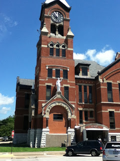
The business district extends for several blocks in each direction. This is not just a frou-frou façade, but the place where the real business of the town is conducted. That includes legal business, in the historic courthouse.

There are several downtown churches, as well, each built on the traditional model Gary Jacobsen calls "embedded" (The Space Between, Baker Academic, 2012, pp. 189-190):
First Christian Church, B Avenue and 2nd Street

First Baptist Church, 2nd Avenue and 2nd Street
The middle school and upper elementary school are close by. (I did see a Wal-Mart and an empty big box store on the road out of town. I didn't see a grocery store.)

The edge of the business district blends seamlessly into residential areas.

There is a mix of housing types in the blocks I walked. Most seemed in good repair; few were as cool as this one.

Recent downtown beautification efforts have worked with the walkable development today's Washington has inherited. I'm not entirely charmed by the results. The walkways through Central Park form a cross and a diamond. These lead to crosswalks mid-block, each clearly demarked by brick, but none at the corners. The sidewalks simply end across from the park.

The mid-block crosswalks aren't ideal, either. The streets around Central Park feature head-in angle parking on both sides of the street as well as two rows (one each way) in the middle of the street. This means there's plenty of parking, so stores and churches don't have to provide their own lots. With all the cars parked everywhere, though, it makes it hard to see into the intersection when crossing.
Crossing from park to the library from the vantage point of a 6 foot tall man
Jeff Speck wrote in Walkable City (Farrar Straus and Giroux, 2012, p. 184) that "cycle lanes behind head-in parking are basically suicidal." There aren't cycle lanes in Washington, nor would there need to be in a town of this size, but with two rows of head-in parking each way I didn't see much biking anyhow. The few cyclists I saw, foregoing suicide, tended to retreat to the sidewalk...
...which, along all those storefronts, created their own dangers.

Which is merely to say that, Washington, despite its good start on the 21st century, doesn't have all the answers. But who does?

SEE ALSO

Ben Kaplan, "What is Urbanism?" We Create Here, 13 April 2015, http://www.wecreatehere.net/2015/04/13/what-is-urbanism/

Monday, July 20, 2015

CR churches


A collection of small churches south of downtown Cedar Rapids speaks to the role houses of worship have historically played, and can still play, in resilient communities. Decades ago, when Cedar Rapids (and all other American cities) was a compact town, the residential areas around downtown featured a wide variety of Christian churches. Some of them--most recently, People's Church (Unitarian-Universalist) and First Christian Church (Disciples of Christ)--have been demolished to make room for bland new commercial development. Both churches relocated to the west side in 2011. Mt. Zion Missionary Baptist Church, formed in Oak Hill-Jackson in 1914, relocated after the 2008 flood from 824 8th Street SE (where it had resided since 1916) to the edge of town.
Former home of Mt. Zion Missionary Baptist Church; from church website
That property is now part of a parking lot.

But others remain, continue to serve congregations, and are among the assets Cedar Rapids carries into our uncertain century.

Dallas May, writing on the Dallas-based Street Smarts blog (cited below), notes that houses of worship have special roles to play in the community:
Churches (at least in principle) offer a unique niche in a community. Churches really serve as the only institution where everyone is welcome. A random person off the street isn’t allowed to just walk into an elementary school, for example.... At Church I am connected to many people from all walks of life that there is simply no other way I would come in contact with.
In an earlier post, he adds:
God is found in the city because he is found in the people of the city who bear his image. The people who chat with other commuters on the train. The people who give generously of their time and wealth.... Hundreds of thousands of people who, each day, make small choices that--against cold logic, rationality and evolution--do good and loving things for the sake of their community and their city.
Rev. Eric O. Jacobsen (2012: 189-190) distinguishes church buildings by how they relate to the built environment around them. Embedded churches fit into pre-1945 human-scaled neighborhoods by being built to the sidewalk, and with little or no space between them and other buildings (e.g. for parking lots). Insular churches, typically built after 1945 in suburban developments, sit on large lots and feature large parking areas onto which their main doors open. Their architecture also tends to be more "utilitarian" than the grand style of older churches. All the churches in central Cedar Rapids fit Jacobsen's "embedded" category. However, the oldest and grandest Third Avenue churches have coped with the automobile age by expanding their parking areas into the surrounding neighborhood.

A number of small churches were built south of downtown Cedar Rapids, in the area known as Oakhill-Jackson, in an era when the predominantly residential neighborhood was thriving and populous. Eric A. Smith's history of Oak Hill-Jackson describes an ethnically-diverse, working class neighborhood in mid-century including most of Cedar Rapids's small black population (pp 32-35). He quotes his uncle, Clarence Smith Jr:
If there was any type of separation, it was more of an economic division. The community played, worked and went to school together. There were no pressures compared to today, everyone knew you in the neighborhood. All the neighbors checked on all the kids in the neighborhood. It was a type of global village. It was the sort of neighborhood where everyone in the community felt secure. (Smith 15)


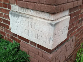
Arguably the most historically important of the churches in Oakhill-Jackson is Bethel African Methodist Episcopal Church (pictured above), 512 6th Street SE, housing a congregation that has met on this site since 1872. In 2008 Preservation Iowa considered it endangered by medical expansion, but the MedQuarter Plan as evolved appears to me to allow not only the survival of the building but the potential for some residential development around it (see esp. the "Land Use Framework" on page 12 of the plan).

The building today looks rather lonely (compare to the 1931 picture at Smith 42):

The cornerstone was laid in 1931, replacing a smaller structure on the same site.

Smith interviewed long-time Bethel member Connie Hillsman in 2005:
Being one if not the earliest black church [Bethel] has remained a symbol of perseverance through all economies. Not a rich nor affluent church... the building has always been modest but membership included blacks of all of the earliest social and fraternal organizations. [It has served to]maintain the reputation of honest and hardworking families and was supported by the black community and the business community of Cedar Rapids (p. 40).
New Jerusalem Church of God in Christ meets in a 100-year-old building at 631 9th Avenue SE. That puts it on the other side of 8th Avenue from Bethel. 8th is a major trafficway which along with the mostly empty quarter to its north creates something of a barrier between Oak Hill-Jackson (as well as New Bohemia) and downtown.

The building was previously the home of Hus Presbyterian Church, which relocated to the southwest side in 1973, after having met in Oak Hill-Jackson since 1889.


The approach along 7th Street:


...leading to this beautiful entrance:


Oak Hill Jackson Community Church is 1202 10th Street SE, along the arterial that is 12th Avenue. The website is pretty barebones, but the building seems like it's been here awhile. The service length alone (10:30-1:00) suggests they worship in the Pentecostal tradition.


The main entrance is on 10th Street, appearing to be a more recent addition:

There are some modest stained glass windows facing 12th Avenue:

Down 12th Avenue is St. Wenceslaus Catholic Church, 1224 5th Street SE, founded in 1874. The current church was built in 1904; the campus includes two other buildings. It's close enough to the river that it took on a lot of water in 2008, but has been completely recovered. Besides two regular weekend masses they do the "extraordinary form of the Latin rite" at 7:00 Sundays.

St. Wenceslaus also hosts the monthly meetings of the Oak Hill-Jackson Neigborhood Association.

There are also some smaller church buildings and house churches in the neighborhood. Fellowship Missionary Baptist Church, 1030 7th Avenue SE, was built in 1965. 

The church at at 930 9th Street SE has no identifying marks. It may be Southeast Church of Christ, which is listed in some Internet phone directories but not in the old-fashioned paper one. The building dates from 1900; obviously the siding is more recent. The front door opens directly onto the intersection of the sidewalks at 9th Street and 10th Avenue.

There is a flourishing garden between the church building and the house next door on 10th Avenue:

By the 1980s the factories where Oak Hill-Jackson residents worked had closed, and the neighborhood deteriorated (Smith 98-99). But while grocery stores and other businesses disappeared when the houses were torn down, these churches remain. Public and private financial imbalance, energy costs or just plain individual preference are likely to push people back to the city center. In fact, just this month another new apartment building was opened in Oak Hill-Jackson, dedicated to civic leader Dr. Percy Harris. As this happens, the churches will be waiting, ready to resume their places as neighborhood centers.

WORKS CITED

Zak Hingst, "Iowa Sacred Places," Preservation Iowa, http://www.preservationiowa.org/initiatives/sacred.php

Eric O. Jacobsen, The Space Between: A Christian Engagement with the Built Environment (Baker Academic, 2012), esp. ch. 7

Dallas May, "Part 3: The Value of the Neighborhood Church," Street Smart: Leading the Way toward Dallas' Urban Future, 28 June 2015, http://streetsmart.dmagazine.com/2015/06/28/part-3-the-value-of-the-neighborhood-church/ 

Eric A. Smith, Oak Hill: A Portrait of Black Life in Cedar Rapids, Iowa (Amen-Ra Theological Seminary Press, 2006)

Friday, July 17, 2015

VIDEO: Chuck Marohn in Iowa City

Chuck Marohn (Source: strongtowns.org)

The Iowa City public access channel, City Channel 4, recorded the Curbside Chat by Strong Towns President Charles Marohn on Tuesday, June 30, 2015. The link is http://view.earthchannel.com/PlayerController.aspx?PGD=iowacity&eID=1276. The entire presentation, including Q-and-A, runs 1:45:00.

Iowa City-based readers may also view the talk on City Channel 4 at the following times:
July 18, 2015 @ 09:00 AM
July 20, 2015 @ 06:00 AM
July 20, 2015 @ 05:00 PM
July 22, 2015 @ 02:00 PM
July 23, 2015 @ 12:00 AM
July 24, 2015 @ 10:00 PM

OTHER STORIES:

Charles Marohn, "Iowa DOT Chief: The System is Going to Shrink," Strong Towns, 6 July 2015
B.A. Morelli, "Road System Will Shrink, DOT Says," Cedar Rapids Gazette, 15 July 2015, 1A, 15A

Sunday, July 12, 2015

Chicago: Bloomingdale Trail and Bucktown


This week marks the first "monthiversary" of Chicago's Bloomingdale Trail, also known as the 606, which opened with great fanfare and no coincidence on June 6. It's a high-trestle trail, constructed along abandoned railroad tracks, running east-west for 2.7 miles on the west side of Chicago. As can be seen on this map, it runs alongside Bloomingdale Avenue (1800 N)--hence the name--between Ashland (1600 W) and Ridgeway (3750 W) Avenues. No doubt it was inspired by New York's High-Line Trail. 80,000 people live within ten minutes' walk from the trail.

We walked on the morning of what would become a hot, humid Monday. The trail was well-used by people of all ages and physical conditions--mostly pedestrians, with some cyclists. My friend Mary Scott-Boria, who lives nearby and is a tireless evangelist for the trail who has been on it at least four days a week since it opened, reports it gets more crowded towards mid-day and stays so well into the evening. Use is particularly heavy on weekends. The trail seems mainly oriented to recreation, but it would give someone in Humboldt Park or Logan Square at least a start on their commute downtown.

The trail is nicely landscaped, with inviting entrances (here, at Milwaukee Avenue near the CTA blue line) :

...and this stylin' bridge over Milwaukee Avenue:

A more basic entrance, but handicapped-accessible, at Damen Avenue:

Maps are posted along the trail near major streets:

The east end of the trail is flanked mainly by condominiums...

...and (here) artists' lofts; about Rockwell Avenue the built environment switches abruptly to houses.

The trail seems to have stimulated development, or at least the search for synergy. If you lived here, you'd be home now:

There's a nice overlook of Humboldt Boulevard (the large Humboldt Park is two blocks south of the trail).

A number of public and private schools are convenient to the trail...

...and indeed we met a group from a summer school program on their way to the park for some fishing:

At the west end of the trail, near its terminus at Lawndale Avenue, there is a sort of curlicue track around a hill, which makes for an elaborate turn-around if trail users so choose.


Along with construction of the trail, four new neighborhood parks are being developed at street level. This is the play space at the enlarged Kimball Park:

Trees and shrubs are being planted along the trail--we saw numerous park district employees at work on various projects. This is clearly a project in which the City of Chicago is heavily invested, but I expect the amount of effort needed to keep the plantings watered and weeded is not sustainable by the city alone. The 606 website is soliciting donations through the Trust for Public Land; perhaps local outdoor organizations could also contribute volunteer efforts.

The trail begins at Ashland Avenue in the Bucktown neighborhood; west of Western Avenue it runs along the boundary between Humboldt Park and Logan Square. According to entries in the encyclopedic Chicago Neighborhoods and Suburbs: A Historical Guide, edited by historian Ann Durkin Keating of the esteemed North Central College:
  • Bucktown is believed to be named for goats that used to graze there in the 19th century. It was annexed to the city in 1863. After that it was a Polish working-class neighborhood, and now is gentrifying (Essig 117). Parts of this area are also considered parts of Logan Square, West Town and Wicker Park. For example, both Bucktown and Wicker Park lie between Ashland and Western Avenues. Wicker Park extends from Bloomingdale south to Division; Bucktown extends from North north to Fullerton. All of these areas south of Bloomingdale are within the official boundaries of West Town (Essig 117, Essig 301, Best 307). One's best approach as an Iowan is to smile and nod knowingly. I guess this is why we need banners.
  • Humboldt Park has been part of Chicago since 1869, and is named for the 207-acre flagship park, which in turn was named for Prussian naturalist Alexander von Humboldt (1769-1859). Then it was ethnically dominated by Danes, Germans and Norwegians; today it is primarily Dominican, Mexican and Puerto Rican, as well as African-American. In contrast to the condos of Bucktown, Humboldt Park is mostly small, single-family homes (Badillo 174-175).
  • Logan Square is more upscale than Humboldt Park, but also primarily Latino. It was annexed in three stages between 1863 and 1889. Milwaukee Avenue was once to be a farm-to-market road. It's a mix of single-family homes and apartments (Patterson 199-200).
The east terminus of the trail is in the clearly-gentrified Bucktown neighborhood, convenient to two establishments I'd been advised to check out. Ipsento Coffee, 2035 N. Western Avenue, near the CTA blue line, was named one of the twelve best independent coffeehouses in the U.S. by Culture Trip.

I can't comment on that level of comparison, but I can say the coffee was smooth and delicious, and the interior was cozy.

Decorative shelves built from books, including the autobiography of the notorious Donald Trump, were a quirky and creative touch.
 
Quimby's Bookstore, 1854 W. North Avenue, is near the Damen stop on the blue line.

They stock a variety of offbeat selections, including comics and zines by local authors. 
Quimby's is at press time the only place you can purchase It's Still Happening: A Sequel by Theora Kvitka.

We finished our morning in Bucktown with lunch at Goddess and Grocer, 1649 N. Damen.
 
BACKGROUND MATERIAL: Ann Durkin Keating (ed), Chicago Neighborhoods and Suburbs: A Historical Guide (University of Chicago, 2008). Entries by David A. Badillo ("Humboldt Park"), Wallace Best ("Wicker Park"), Steven Essig ("Bucktown" and "West Town") and Elizabeth A. Patterson ("Logan Square")

Can there be too much of a good thing?

Barcelona (from Wikimedia Commons) I've never been to Barcelona--in fact, I've never been to Spain --but Barcelona, like Amsterdam, ...