
Cedar Rapids residents discussed the future of the city with city staff and hired planners Wednesday night in the lobby of the National Czech and Slovak Museum and Library. We were met with a series of posters which I mostly found unhelpful if not outright bewildering. There were some good supportive materials, though, and some explanation was available if you asked for it.
Wellington Heights
I spent some quality time with the Wellington Heights Neighborhood Plan, and came away with the strong impression that the city is interested in using design initiatives to improve neighborhoods. The plan includes discussion of making the roads at the edge of the neighborhood, particularly Mt. Vernon Rd. and 10th St., more easily crossable. From my perspective 10th Street is especially critical, because it is the boundary between Wellington Heights and the emerging MedQuarter district (and beyond it to downtown). People who now live in Wellington Heights must be connected to the opportunities that come from economic development. The plan also includes infill development of housing for the MedQuarter workforce, extended hours for bus service, and taming the one-way streets that now slash across the neighborhood.
I'm all for it. People are raising children along 2nd and 3rd Avenues, but with traffic whizzing by at 40 mph, that hardly seems optimal. But much of past city development has been based on people driving fast through Wellington Heights on their ways to downtown or across town. What happens to that traffic, not to mention the cars that use Mt. Vernon Rd., which is to go on a "road diet?" Can it all be diverted to 1st Avenue? Understand, I'm not happy that Cedar Rapids and the I-380 Corridor writ large have developed in such a car-dependent way, but they have been. (Come to think of it, I didn't see any transportation plans at the open house. I'll have to look for that next time.)
So I'm concerned about that, and where the jobs are going to come from. But I'm pleased to see the city thinking about downtown and the surrounding areas in an integrated way.

(This map goes from St. Luke's Hospital, in blue on the upper right, across the river to the proposed Kingston neighborhood development. No mention of the casino, which will be plopped between the Kingston neigbhorhood and the riverside greenway depicted at left.)
Highway 100 Extension
I was intrigued by a series of posters presented by H.R. Green Engineering, which has been hired to coordinate planning for the area around the extension of Highway 100 to the west of the city. I was intrigued in spite of myself, because my preference is that the highway not be extended at all, and that does not appear to be an option. H.R. Green offered three maps (depicted below), which respectively described an "urbanism scenario" (left) with walkable neighborhoods of mixed development and accessible stores; a "standard development practice scenario" (top right) consisting mostly of large lot subdivisions with some commercial buildings along the new highway; and a "conservation scenario" (bottom middle) with more green space.

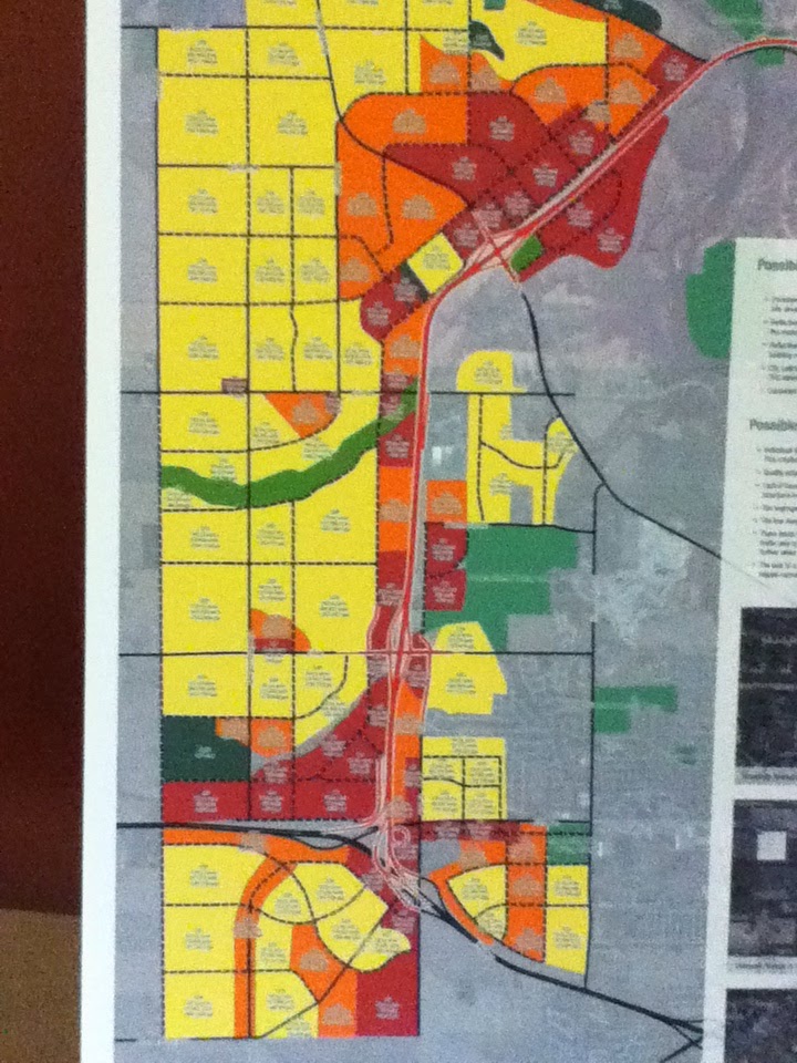

On the maps, explained their helpful representative, Jim Halverson, yellow is low-density housing, light green is mutlifamily housing, and maroon is mixed-use commercial. The walkable version of the subdivision is indeed intriguing, and came with credit to Andres Duany et al., but it seems to require a sizeable increase in population to support this. It's nice to think that if the city grew substantially, it could do so in a sustainable way, but absent a growth surge isn't this an unnecessary spread of infrastructure? (Which, I should remind you, doesn't come cheap. The highway alone comes to $250 million.) It is possible, however, that I'm just being an old poop.
Two more open houses are coming soon: a draft plan review April 24, and a final plan review June 12. The Corridor Metropolitan Planning Organization (MPO) website is at http://www.corridormpo.com/.
EARLIER POSTS ON CEDAR RAPIDS DEVELOPMENT
"Downtown, Where All the Lights are Bright?" November 10, 2013
"Filling in an Empty Quarter (II)," October 25, 2013
"Downtown vs. Parking," September 29, 2013
"Their Casino, Our Casino," September 5, 2013
"Taylor Area Neighborhood," August 25, 2013
"A Big Ho Hum," May 12, 2013


We went last night as well, and found the same things to be true...largely unhelpful boards, but people willing to talk, if you had questions. I asked about the Mt. Vernon Road "road diet", and am very concerned. Although I understand the desire to make it more walkable, and definitely agree with that, I have travelled that area frequently, and I just can't see how reducing the lanes will make it anything but frustrating. I asked. if the idea was to divert traffic to other areas, and the gentleman at the booth said, "no, not at all." I am definitely interested in knowing more about the reasoning, and asking more questions about the "diet".
ReplyDelete